K06A Valley Falls, OR, USA - Earthquake Result Viewer
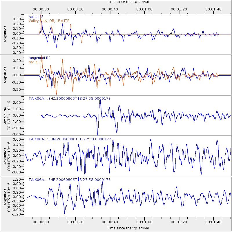
Earthquake location: Bonin Islands, Japan Region
Earthquake latitude/longitude: 26.1/144.0
Earthquake time(UTC): 2006/08/06 (218) 18:16:40 GMT
Earthquake Depth: 23 km
Earthquake Magnitude: 6.0 MB, 5.6 MS, 5.8 MW, 5.8 MW
Earthquake Catalog/Contributor: WHDF/NEIC
Network: TA USArray Transportable Network (new EarthScope stations)
Station: K06A Valley Falls, OR, USA
Lat/Lon: 42.80 N/120.25 W
Elevation: 1340 m
Distance: 76.7 deg
Az: 48.811 deg
Baz: 293.187 deg
Ray Param: 0.050800256
Estimated Moho Depth: 40.25 km
Estimated Crust Vp/Vs: 1.90
Assumed Crust Vp: 6.597 km/s
Estimated Crust Vs: 3.463 km/s
Estimated Crust Poisson's Ratio: 0.31
Radial Match: 85.15629 %
Radial Bump: 400
Transverse Match: 77.98812 %
Transverse Bump: 400
SOD ConfigId: 2665
Insert Time: 2010-03-07 03:16:42.975 +0000
GWidth: 2.5
Max Bumps: 400
Tol: 0.001

Signal To Noise

ChannelStoNSTALTA
TA:K06A: :BHN:20060806T18:27:58.000017Z1.10910751.8432377E-71.6619107E-7
TA:K06A: :BHE:20060806T18:27:58.000017Z1.38746232.5399763E-71.8306633E-7
TA:K06A: :BHZ:20060806T18:27:58.000017Z11.0986341.345159E-61.2120043E-7
Arrivals
Ps5.7 SECOND
PpPs17 SECOND
PsPs/PpSs23 SECOND