You are here: Home > Network List > TA - USArray Transportable Network (new EarthScope stations) Stations List
> Station L22K Petersville, AK, USA > Earthquake Result Viewer
L22K Petersville, AK, USA - Earthquake Result Viewer
| Earthquake location: |
Mariana Islands |
| Earthquake latitude/longitude: |
16.6/146.4 |
| Earthquake time(UTC): |
2019/08/18 (230) 18:00:29 GMT |
| Earthquake Depth: |
34 km |
| Earthquake Magnitude: |
5.9 Mi |
| Earthquake Catalog/Contributor: |
NEIC PDE/pt |
|
| Network: |
TA USArray Transportable Network (new EarthScope stations) |
| Station: |
L22K Petersville, AK, USA |
| Lat/Lon: |
62.53 N/150.77 W |
| Elevation: |
817 m |
|
| Distance: |
63.0 deg |
| Az: |
27.587 deg |
| Baz: |
253.243 deg |
| Ray Param: |
0.059824977 |
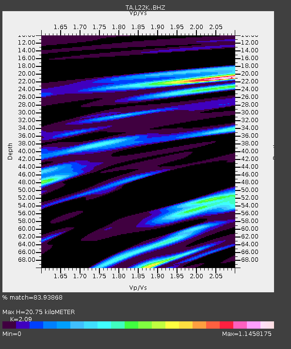
| Estimated Moho Depth: |
20.75 km |
| Estimated Crust Vp/Vs: |
2.09 |
| Assumed Crust Vp: |
6.438 km/s |
| Estimated Crust Vs: |
3.08 km/s |
| Estimated Crust Poisson's Ratio: |
0.35 |
|
| Radial Match: |
83.93868 % |
| Radial Bump: |
400 |
| Transverse Match: |
88.62079 % |
| Transverse Bump: |
400 |
| SOD ConfigId: |
19053131 |
| Insert Time: |
2019-09-01 18:13:08.324 +0000 |
| GWidth: |
2.5 |
| Max Bumps: |
400 |
| Tol: |
0.001 |
|
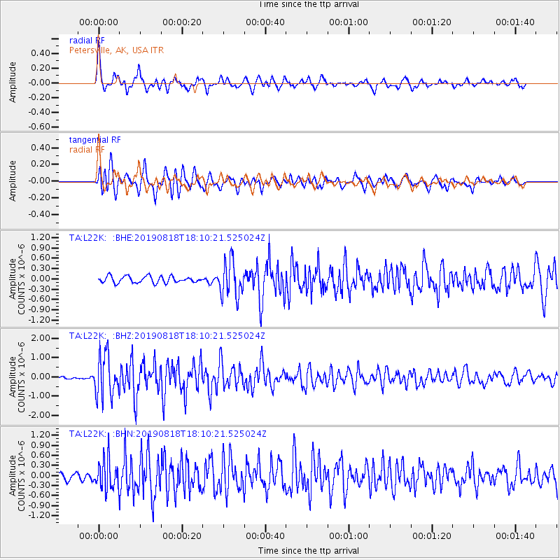
Signal To Noise
| Channel | StoN | STA | LTA |
| TA:L22K: :BHZ:20190818T18:10:21.525024Z | 14.652409 | 1.077662E-6 | 7.3548456E-8 |
| TA:L22K: :BHN:20190818T18:10:21.525024Z | 4.5875626 | 4.5924304E-7 | 1.0010611E-7 |
| TA:L22K: :BHE:20190818T18:10:21.525024Z | 5.5726643 | 5.2690757E-7 | 9.4552185E-8 |
| Arrivals |
| Ps | 3.6 SECOND |
| PpPs | 9.6 SECOND |
| PsPs/PpSs | 13 SECOND |


