You are here: Home > Network List > TA - USArray Transportable Network (new EarthScope stations) Stations List
> Station S14A Cedar City, UT, USA > Earthquake Result Viewer
S14A Cedar City, UT, USA - Earthquake Result Viewer
| Earthquake location: |
South Of Fiji Islands |
| Earthquake latitude/longitude: |
-26.0/-177.5 |
| Earthquake time(UTC): |
2007/12/09 (343) 07:28:20 GMT |
| Earthquake Depth: |
152 km |
| Earthquake Magnitude: |
7.0 MB, 7.8 MW, 7.7 MW |
| Earthquake Catalog/Contributor: |
WHDF/NEIC |
|
| Network: |
TA USArray Transportable Network (new EarthScope stations) |
| Station: |
S14A Cedar City, UT, USA |
| Lat/Lon: |
37.76 N/113.17 W |
| Elevation: |
1746 m |
|
| Distance: |
87.5 deg |
| Az: |
45.651 deg |
| Baz: |
234.293 deg |
| Ray Param: |
0.042911474 |
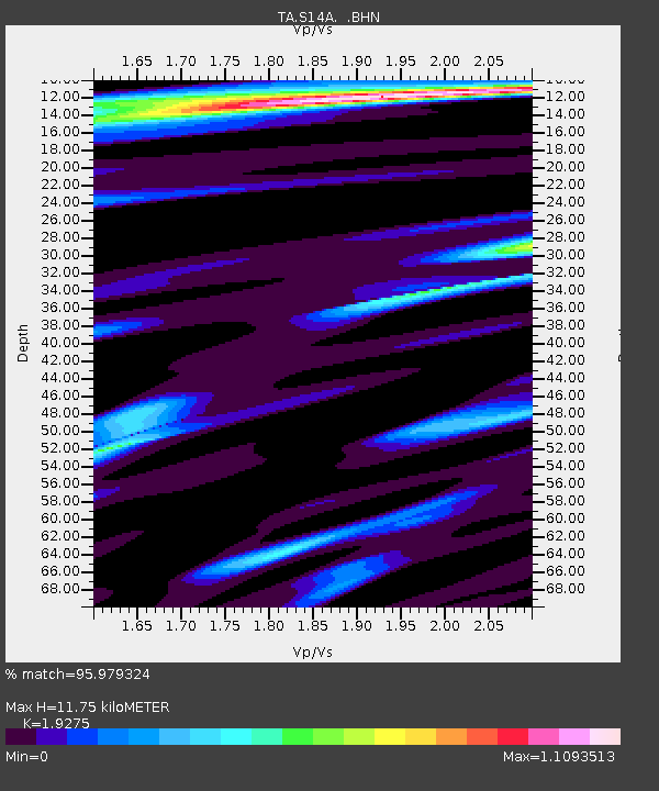
| Estimated Moho Depth: |
11.75 km |
| Estimated Crust Vp/Vs: |
1.93 |
| Assumed Crust Vp: |
6.194 km/s |
| Estimated Crust Vs: |
3.214 km/s |
| Estimated Crust Poisson's Ratio: |
0.32 |
|
| Radial Match: |
95.979324 % |
| Radial Bump: |
280 |
| Transverse Match: |
91.93452 % |
| Transverse Bump: |
400 |
| SOD ConfigId: |
2564 |
| Insert Time: |
2010-03-07 03:19:04.078 +0000 |
| GWidth: |
2.5 |
| Max Bumps: |
400 |
| Tol: |
0.001 |
|

Signal To Noise
| Channel | StoN | STA | LTA |
| TA:S14A: :BHN:20071209T07:40:20.249016Z | 0.67489827 | 1.6327274E-7 | 2.41922E-7 |
| TA:S14A: :BHE:20071209T07:40:20.249016Z | 2.0169191 | 5.182939E-7 | 2.569731E-7 |
| TA:S14A: :BHZ:20071209T07:40:20.249016Z | 5.2937884 | 1.1244373E-6 | 2.124069E-7 |
| Arrivals |
| Ps | 1.8 SECOND |
| PpPs | 5.5 SECOND |
| PsPs/PpSs | 7.2 SECOND |


