
Station TA S14A - Cedar City, UT, USA
Network: TA - USArray Transportable Network (new EarthScope stations)
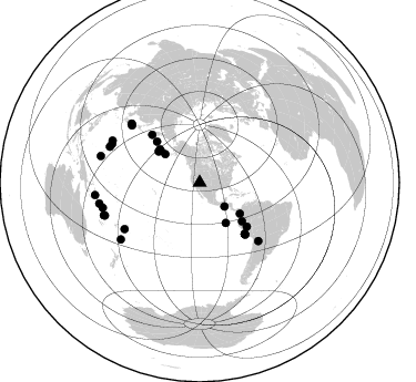
Nearby stations (2 deg radius)
| Station | Name | (Lat, Lon) | Start / End | Elevation |
| S14A | Cedar City, UT, USA | (37.76, -113.17) | 2007-01-27 / 2499-01-01 | 1.7 km |
| Crust2 Type: | MD,thin extended crust, 1.5 km seds. |
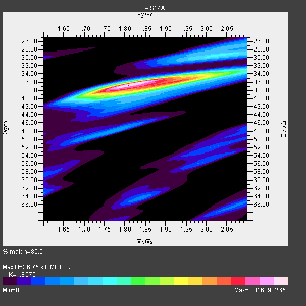
| Thickness Estimate: | 37 km |
| Thickness StdDev: | 1.3 km |
| Vp/Vs Estimate: | 1.81 |
| Vp/Vs StdDev: | 0.07 |
| Vs Estimate: | 3.427 km/s |
| Poisson's Ratio: | 0.28 |
| Peak Value: | 0.02 |
| Assumed Vp: | 6.194 km/s |
| Ps Weight: | 0.33333334 |
| PpPs Weight: | 0.33333334 |
| PsPs Weight: | 0.33333328 |
| Residual Complexity: | 0.579 |
| Nearby stations H: | +- |
| (2.0 deg) Vp/Vs: | +- |
11 with match > 90% ( 37.931034 %) and 29 with match > 80% ( 100.0 %) out of 29.
Download stack as xyz text file.
Azimuth Distribution of Events:
Prior Results for this Station
| Study | Thickness | Vp/Vs | Vp | Vs | Poissons Ratio | Extra |
| EARS | 37 km | 1.81 | 6.194 km/s | 3.427 km/s | 0.28 | |
| Crust2.0 | 34 km | 1.78 | 6.194 km/s | 3.483 km/s | 0.27 | MD,thin extended crust, 1.5 km seds. |
| Global Maxima | 37 km | 1.81 | 6.194 km/s | 3.427 km/s | 0.28 | amp=0.016093265 |
| Local Maxima 1 | 36 km | 1.91 | 6.194 km/s | 3.247 km/s | 0.31 | amp=0.009380377 |
| Local Maxima 2 | 34 km | 1.99 | 6.194 km/s | 3.117 km/s | 0.33 | amp=0.005159716 |
| Local Maxima 3 | 40 km | 1.74 | 6.194 km/s | 3.555 km/s | 0.25 | amp=0.004302006 |
| Local Maxima 4 | 28 km | 2.01 | 6.194 km/s | 3.078 km/s | 0.34 | amp=0.004032194 |
| Predicted Arrivals for vertical incidence (zero ray parameter) | |
| Ps | 4.79 SECOND |
| PpPs | 16.66 SECOND |
| PsPs/PpSs | 21.45 SECOND |
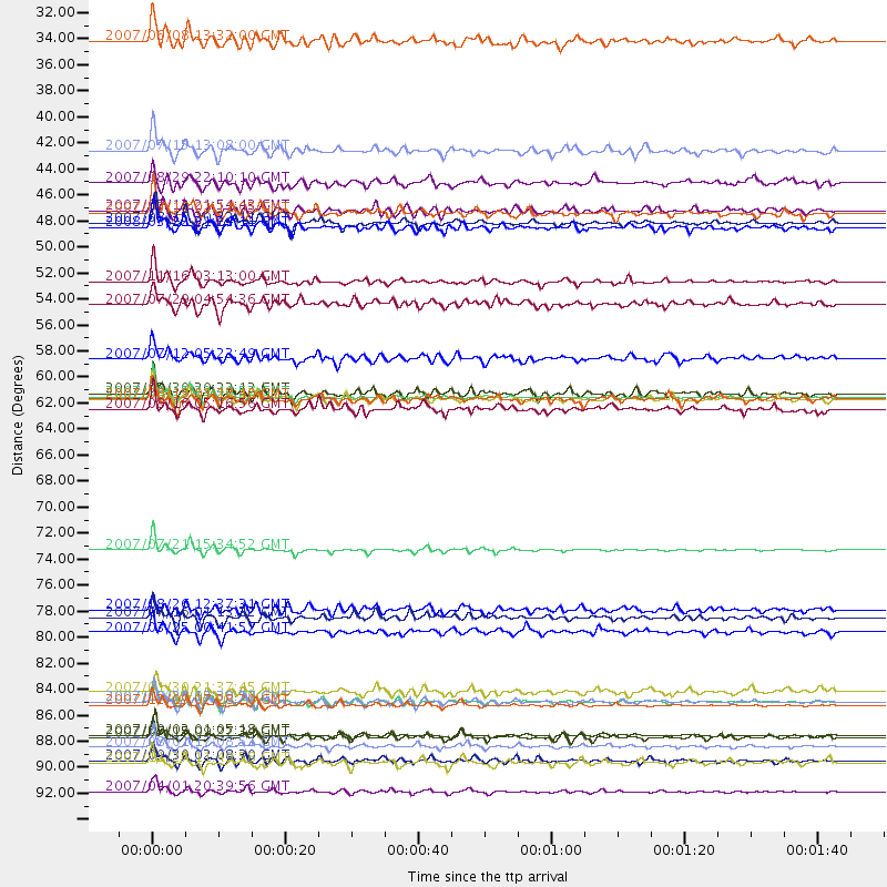
Events Processed for this Station
Download zip of receiver functions as SAC
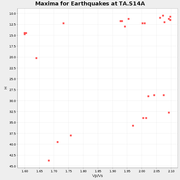
Plot maxima for each earthquake.
Events Used in the Stack
(29 events)| Radial Match | Distance | Baz | FERegion | Time | Lat/Lon | Depth | Magnitude |
| 97.93068 | 90.1 deg | 255.45 deg | Santa Cruz Islands | 2007/09/02 01:05:18 GMT | (-11.6, 165.8) | 35 km | 5.9 MB, 7.3 MS, 7.2 MW, 6.9 ME |
| 97.607216 | 61.4 deg | 138.658 deg | Near Coast Of Peru | 2007/08/15 23:40:57 GMT | (-13.4, -76.6) | 39 km | 6.7 MB, 7.9 MS, 8.0 MW, 7.5 ME |
| 96.45325 | 94.9 deg | 263.194 deg | Solomon Islands | 2007/04/01 20:39:56 GMT | (-8.5, 157.0) | 10 km | 6.8 MB, 7.9 MS, 8.1 MW, 7.7 ME |
| 95.979324 | 87.5 deg | 234.293 deg | South Of Fiji Islands | 2007/12/09 07:28:20 GMT | (-26.0, -177.5) | 152 km | 7.0 MB, 7.8 MW, 7.7 MW |
| 95.720245 | 91.1 deg | 251.192 deg | Vanuatu Islands | 2007/08/01 17:08:51 GMT | (-15.6, 167.7) | 120 km | 6.2 MB, 7.2 MW, 7.2 MW |
| 94.52047 | 51.6 deg | 132.466 deg | Peru-Ecuador Border Region | 2007/11/16 03:13:00 GMT | (-2.3, -77.8) | 123 km | 6.3 MB, 6.8 MW, 6.7 MW |
| 93.80609 | 61.0 deg | 315.221 deg | Kamchatka Peninsula, Russia | 2007/05/30 20:22:12 GMT | (52.1, 157.3) | 116 km | 6.4 MB, 6.4 MW, 6.4 MW |
| 93.16809 | 40.4 deg | 309.505 deg | Fox Islands, Aleutian Islands | 2007/07/15 13:08:00 GMT | (52.5, -168.0) | 10 km | 5.8 MB, 5.9 MS, 6.1 MW, 6.0 MW |
| 93.087326 | 87.3 deg | 295.744 deg | Volcano Islands, Japan Region | 2007/09/28 13:38:59 GMT | (22.0, 142.7) | 276 km | 6.7 MB, 7.4 MW, 7.4 MW |
| 92.89286 | 80.1 deg | 310.032 deg | Near West Coast Of Honshu, Japan | 2007/07/16 01:13:22 GMT | (37.5, 138.4) | 12 km | 6.5 MB, 6.4 MS, 6.6 MW, 6.5 MW |
| 92.29011 | 45.5 deg | 309.146 deg | Andreanof Islands, Aleutian Is. | 2007/07/13 21:54:43 GMT | (51.8, -176.3) | 35 km | 5.7 MB, 5.6 MS, 6.0 MW, 5.9 MW |
| 89.18708 | 61.6 deg | 138.788 deg | Near Coast Of Peru | 2007/08/17 13:18:13 GMT | (-13.6, -76.6) | 48 km | 5.6 MB, 5.6 MS, 5.9 MW |
| 89.17549 | 53.5 deg | 313.761 deg | Komandorskiye Ostrova Region | 2007/07/29 04:54:36 GMT | (53.6, 169.7) | 26 km | 6.0 MB, 5.5 MS, 5.9 MW, 5.8 MW |
| 89.09045 | 74.4 deg | 134.895 deg | Jujuy Province, Argentina | 2007/07/21 15:34:52 GMT | (-22.2, -65.8) | 290 km | 5.8 MB, 6.4 MW, 6.3 MW |
| 87.001305 | 47.0 deg | 309.919 deg | Andreanof Islands, Aleutian Is. | 2008/03/22 21:24:11 GMT | (52.2, -178.7) | 132 km | 5.8 MB, 6.2 MW, 6.1 MW |
| 86.34408 | 92.3 deg | 284.993 deg | South Of Mariana Islands | 2007/09/30 02:08:30 GMT | (10.5, 145.7) | 14 km | 6.4 MB, 7.1 MS, 6.9 MW, 6.9 MW |
| 85.2065 | 90.3 deg | 250.799 deg | Vanuatu Islands | 2007/07/15 09:27:34 GMT | (-15.4, 168.6) | 8.0 km | 6.0 MB, 5.8 MS, 6.1 MW, 6.0 MW |
| 84.73256 | 62.4 deg | 138.76 deg | Near Coast Of Peru | 2007/08/16 05:16:56 GMT | (-14.3, -76.1) | 23 km | 5.8 MB, 6.1 MS, 6.3 MW, 6.2 ML |
| 84.53193 | 86.5 deg | 293.749 deg | Mariana Islands | 2007/01/30 21:37:45 GMT | (21.0, 144.7) | 30 km | 6.3 MB, 6.5 MS, 6.6 MW, 6.5 MW |
| 84.101814 | 46.6 deg | 307.237 deg | Andreanof Islands, Aleutian Is. | 2007/08/15 20:22:11 GMT | (50.3, -177.5) | 9.0 km | 6.3 MB, 6.2 MS, 6.4 MW, 5.9 ML |
| 83.72374 | 79.5 deg | 238.271 deg | Tonga Islands | 2007/08/26 12:37:31 GMT | (-17.5, -174.3) | 127 km | 5.9 MB, 6.1 MW |
| 83.562096 | 61.6 deg | 138.817 deg | Near Coast Of Peru | 2007/08/19 01:22:40 GMT | (-13.6, -76.6) | 26 km | 5.9 MB, 5.4 MS, 5.8 MW, 5.5 ML |
| 83.12464 | 87.3 deg | 291.736 deg | Mariana Islands | 2007/10/31 03:30:17 GMT | (18.9, 145.4) | 223 km | 6.2 MB, 7.2 MW, 7.2 MW |
| 82.332214 | 45.7 deg | 127.623 deg | South Of Panama | 2007/03/18 02:11:05 GMT | (4.6, -78.5) | 8.0 km | 6.4 MB, 5.7 MS, 6.2 MW, 6.1 MW |
| 81.33649 | 81.4 deg | 310.858 deg | Near West Coast Of Honshu, Japan | 2007/03/25 00:41:57 GMT | (37.3, 136.6) | 8.0 km | 6.1 MB, 6.8 MS, 6.7 MW, 6.6 MW |
| 80.87659 | 92.5 deg | 258.155 deg | Solomon Islands | 2007/11/27 11:49:58 GMT | (-10.9, 162.1) | 16 km | 5.9 MB, 6.7 MS, 6.6 MW, 6.4 MW |
| 80.62813 | 43.1 deg | 147.053 deg | Galapagos Islands, Ecuador | 2007/08/29 22:10:10 GMT | (-0.6, -91.3) | 23 km | 5.6 MB, 4.8 MS, 5.4 MW |
| 80.493 | 31.1 deg | 134.144 deg | Near Coast Of Guatemala | 2007/06/08 13:32:00 GMT | (13.8, -90.8) | 48 km | 5.5 MB, 5.4 MS, 5.8 MW, 5.8 MW |
| 80.31355 | 58.1 deg | 133.04 deg | Peru-Brazil Border Region | 2007/07/12 05:23:49 GMT | (-7.9, -74.4) | 152 km | 5.9 MB, 6.1 MW, 6.0 MW |
Losers
(0 events)| Radial Match | Distance | Baz | FERegion | Time | Lat/Lon | Depth | Magnitude | Reason |
