You are here: Home > Network List > TA - USArray Transportable Network (new EarthScope stations) Stations List
> Station S14A Cedar City, UT, USA > Earthquake Result Viewer
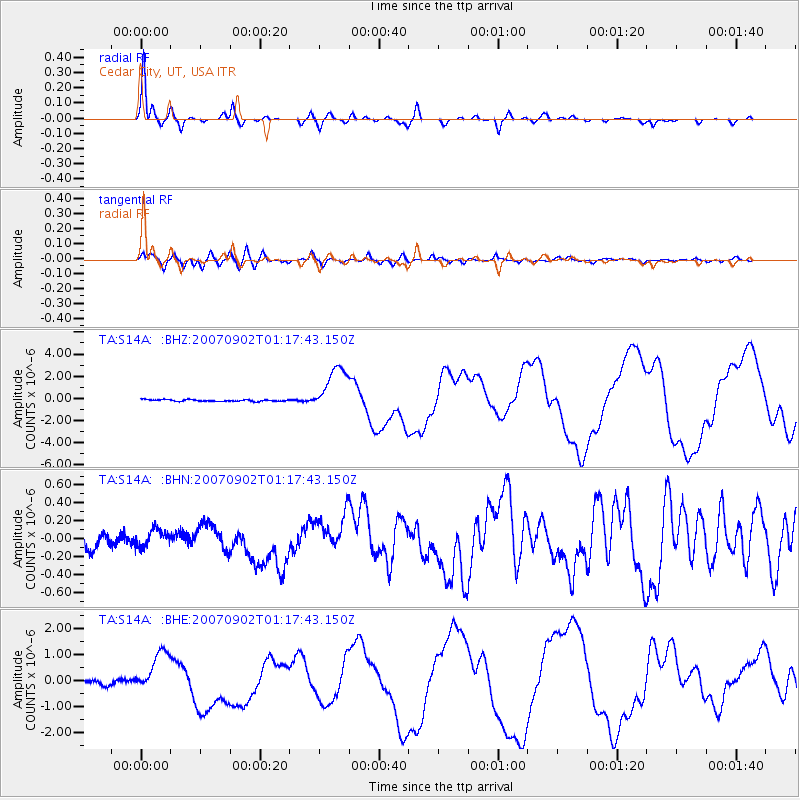
S14A Cedar City, UT, USA - Earthquake Result Viewer

| Earthquake location: |
Santa Cruz Islands |
| Earthquake latitude/longitude: |
-11.6/165.8 |
| Earthquake time(UTC): |
2007/09/02 (245) 01:05:18 GMT |
| Earthquake Depth: |
35 km |
| Earthquake Magnitude: |
5.9 MB, 7.3 MS, 7.2 MW, 6.9 ME |
| Earthquake Catalog/Contributor: |
WHDF/NEIC |
|
| Network: |
TA USArray Transportable Network (new EarthScope stations) |
| Station: |
S14A Cedar City, UT, USA |
| Lat/Lon: |
37.76 N/113.17 W |
| Elevation: |
1746 m |
|
| Distance: |
90.1 deg |
| Az: |
51.532 deg |
| Baz: |
255.45 deg |
| Ray Param: |
0.04169463 |
| Estimated Moho Depth: |
10.5 km |
| Estimated Crust Vp/Vs: |
2.07 |
| Assumed Crust Vp: |
6.194 km/s |
| Estimated Crust Vs: |
2.989 km/s |
| Estimated Crust Poisson's Ratio: |
0.35 |
|
| Radial Match: |
97.93068 % |
| Radial Bump: |
321 |
| Transverse Match: |
94.35005 % |
| Transverse Bump: |
400 |
| SOD ConfigId: |
2564 |
| Insert Time: |
2010-03-07 03:19:17.325 +0000 |
| GWidth: |
2.5 |
| Max Bumps: |
400 |
| Tol: |
0.001 |
|
Signal To Noise
| Channel | StoN | STA | LTA |
| TA:S14A: :BHN:20070902T01:17:43.150Z | 1.2265946 | 9.6536965E-8 | 7.8703245E-8 |
| TA:S14A: :BHE:20070902T01:17:43.150Z | 9.43132 | 8.1331973E-7 | 8.623604E-8 |
| TA:S14A: :BHZ:20070902T01:17:43.150Z | 27.912804 | 2.1015219E-6 | 7.528882E-8 |
| Arrivals |
| Ps | 1.8 SECOND |
| PpPs | 5.1 SECOND |
| PsPs/PpSs | 7.0 SECOND |


