You are here: Home > Network List > TA - USArray Transportable Network (new EarthScope stations) Stations List
> Station S14A Cedar City, UT, USA > Earthquake Result Viewer
S14A Cedar City, UT, USA - Earthquake Result Viewer
| Earthquake location: |
Kamchatka Peninsula, Russia |
| Earthquake latitude/longitude: |
52.1/157.3 |
| Earthquake time(UTC): |
2007/05/30 (150) 20:22:12 GMT |
| Earthquake Depth: |
116 km |
| Earthquake Magnitude: |
6.4 MB, 6.4 MW, 6.4 MW |
| Earthquake Catalog/Contributor: |
WHDF/NEIC |
|
| Network: |
TA USArray Transportable Network (new EarthScope stations) |
| Station: |
S14A Cedar City, UT, USA |
| Lat/Lon: |
37.76 N/113.17 W |
| Elevation: |
1746 m |
|
| Distance: |
61.0 deg |
| Az: |
64.926 deg |
| Baz: |
315.221 deg |
| Ray Param: |
0.060797438 |
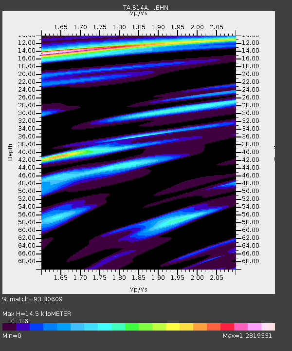
| Estimated Moho Depth: |
14.5 km |
| Estimated Crust Vp/Vs: |
1.60 |
| Assumed Crust Vp: |
6.194 km/s |
| Estimated Crust Vs: |
3.871 km/s |
| Estimated Crust Poisson's Ratio: |
0.18 |
|
| Radial Match: |
93.80609 % |
| Radial Bump: |
400 |
| Transverse Match: |
87.35458 % |
| Transverse Bump: |
400 |
| SOD ConfigId: |
2564 |
| Insert Time: |
2010-03-07 03:19:33.635 +0000 |
| GWidth: |
2.5 |
| Max Bumps: |
400 |
| Tol: |
0.001 |
|

Signal To Noise
| Channel | StoN | STA | LTA |
| TA:S14A: :BHN:20070530T20:31:43.425015Z | 12.691413 | 1.3077907E-6 | 1.0304532E-7 |
| TA:S14A: :BHE:20070530T20:31:43.425015Z | 4.8966355 | 7.9924246E-7 | 1.632228E-7 |
| TA:S14A: :BHZ:20070530T20:31:43.425015Z | 56.927307 | 4.0007376E-6 | 7.0278006E-8 |
| Arrivals |
| Ps | 1.5 SECOND |
| PpPs | 5.8 SECOND |
| PsPs/PpSs | 7.3 SECOND |


