You are here: Home > Network List > TA - USArray Transportable Network (new EarthScope stations) Stations List
> Station S14A Cedar City, UT, USA > Earthquake Result Viewer
S14A Cedar City, UT, USA - Earthquake Result Viewer

| Earthquake location: |
Solomon Islands |
| Earthquake latitude/longitude: |
-8.5/157.0 |
| Earthquake time(UTC): |
2007/04/01 (091) 20:39:56 GMT |
| Earthquake Depth: |
10 km |
| Earthquake Magnitude: |
6.8 MB, 7.9 MS, 8.1 MW, 7.7 ME |
| Earthquake Catalog/Contributor: |
WHDF/NEIC |
|
| Network: |
TA USArray Transportable Network (new EarthScope stations) |
| Station: |
S14A Cedar City, UT, USA |
| Lat/Lon: |
37.76 N/113.17 W |
| Elevation: |
1746 m |
|
| Distance: |
94.9 deg |
| Az: |
52.705 deg |
| Baz: |
263.194 deg |
| Ray Param: |
0.040913004 |
| Estimated Moho Depth: |
11.25 km |
| Estimated Crust Vp/Vs: |
2.09 |
| Assumed Crust Vp: |
6.194 km/s |
| Estimated Crust Vs: |
2.96 km/s |
| Estimated Crust Poisson's Ratio: |
0.35 |
|
| Radial Match: |
96.45325 % |
| Radial Bump: |
400 |
| Transverse Match: |
89.16436 % |
| Transverse Bump: |
400 |
| SOD ConfigId: |
2564 |
| Insert Time: |
2010-03-07 03:19:34.968 +0000 |
| GWidth: |
2.5 |
| Max Bumps: |
400 |
| Tol: |
0.001 |
|
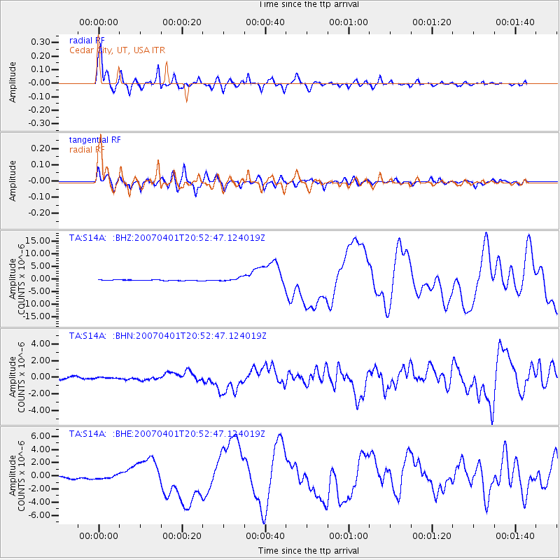
Signal To Noise
| Channel | StoN | STA | LTA |
| TA:S14A: :BHN:20070401T20:52:47.124019Z | 0.66940445 | 8.87104E-8 | 1.3252138E-7 |
| TA:S14A: :BHE:20070401T20:52:47.124019Z | 1.3680222 | 2.891186E-7 | 2.1134056E-7 |
| TA:S14A: :BHZ:20070401T20:52:47.124019Z | 4.855717 | 7.5326074E-7 | 1.5512862E-7 |
| Arrivals |
| Ps | 2.0 SECOND |
| PpPs | 5.5 SECOND |
| PsPs/PpSs | 7.5 SECOND |


