You are here: Home > Network List > TA - USArray Transportable Network (new EarthScope stations) Stations List
> Station S14A Cedar City, UT, USA > Earthquake Result Viewer
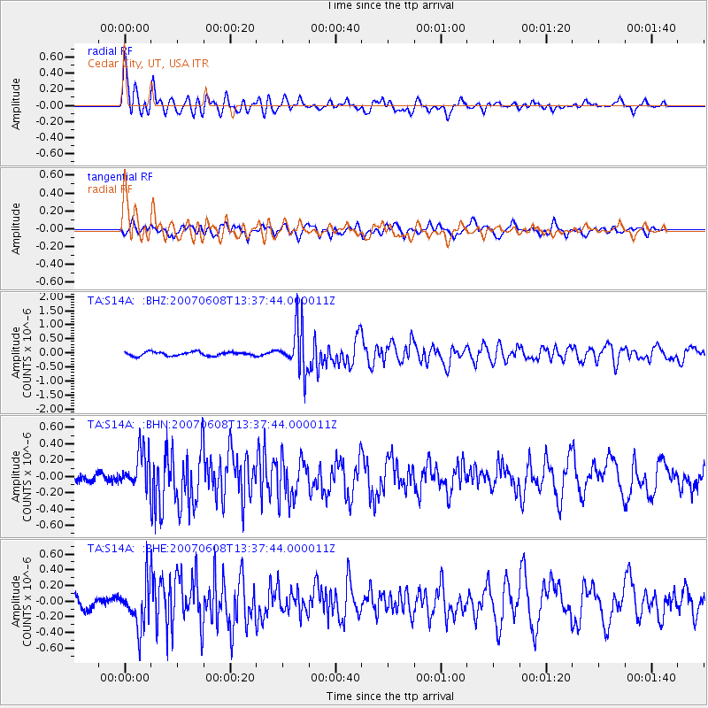
S14A Cedar City, UT, USA - Earthquake Result Viewer

| Earthquake location: |
Near Coast Of Guatemala |
| Earthquake latitude/longitude: |
13.8/-90.8 |
| Earthquake time(UTC): |
2007/06/08 (159) 13:32:00 GMT |
| Earthquake Depth: |
48 km |
| Earthquake Magnitude: |
5.5 MB, 5.4 MS, 5.8 MW, 5.8 MW |
| Earthquake Catalog/Contributor: |
WHDF/NEIC |
|
| Network: |
TA USArray Transportable Network (new EarthScope stations) |
| Station: |
S14A Cedar City, UT, USA |
| Lat/Lon: |
37.76 N/113.17 W |
| Elevation: |
1746 m |
|
| Distance: |
31.1 deg |
| Az: |
324.161 deg |
| Baz: |
134.144 deg |
| Ray Param: |
0.07911051 |
| Estimated Moho Depth: |
12.0 km |
| Estimated Crust Vp/Vs: |
2.08 |
| Assumed Crust Vp: |
6.194 km/s |
| Estimated Crust Vs: |
2.982 km/s |
| Estimated Crust Poisson's Ratio: |
0.35 |
|
| Radial Match: |
80.493 % |
| Radial Bump: |
400 |
| Transverse Match: |
70.08822 % |
| Transverse Bump: |
400 |
| SOD ConfigId: |
2564 |
| Insert Time: |
2010-03-07 03:19:54.999 +0000 |
| GWidth: |
2.5 |
| Max Bumps: |
400 |
| Tol: |
0.001 |
|
Signal To Noise
| Channel | StoN | STA | LTA |
| TA:S14A: :BHN:20070608T13:37:44.000011Z | 4.1355433 | 2.3704759E-7 | 5.731957E-8 |
| TA:S14A: :BHE:20070608T13:37:44.000011Z | 3.540194 | 2.864151E-7 | 8.090378E-8 |
| TA:S14A: :BHZ:20070608T13:37:44.000011Z | 12.228635 | 8.2805116E-7 | 6.771411E-8 |
| Arrivals |
| Ps | 2.2 SECOND |
| PpPs | 5.6 SECOND |
| PsPs/PpSs | 7.8 SECOND |


