You are here: Home > Network List > TA - USArray Transportable Network (new EarthScope stations) Stations List
> Station C08A Higginbotham Farm, Almira, WA, USA > Earthquake Result Viewer
C08A Higginbotham Farm, Almira, WA, USA - Earthquake Result Viewer
| Earthquake location: |
Windward Islands |
| Earthquake latitude/longitude: |
15.0/-61.3 |
| Earthquake time(UTC): |
2007/11/29 (333) 19:00:19 GMT |
| Earthquake Depth: |
148 km |
| Earthquake Magnitude: |
6.9 MB, 7.4 MW, 7.4 MW |
| Earthquake Catalog/Contributor: |
WHDF/NEIC |
|
| Network: |
TA USArray Transportable Network (new EarthScope stations) |
| Station: |
C08A Higginbotham Farm, Almira, WA, USA |
| Lat/Lon: |
47.78 N/119.05 W |
| Elevation: |
783 m |
|
| Distance: |
57.5 deg |
| Az: |
317.439 deg |
| Baz: |
104.227 deg |
| Ray Param: |
0.062980816 |
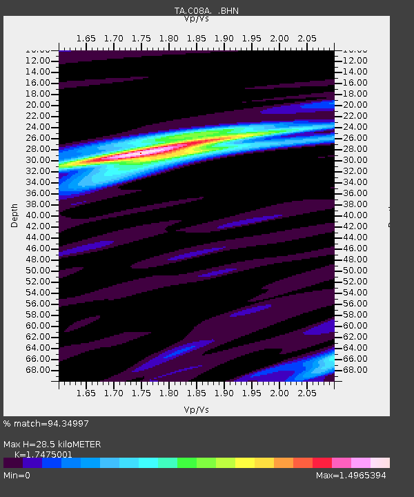
| Estimated Moho Depth: |
28.5 km |
| Estimated Crust Vp/Vs: |
1.75 |
| Assumed Crust Vp: |
6.419 km/s |
| Estimated Crust Vs: |
3.673 km/s |
| Estimated Crust Poisson's Ratio: |
0.26 |
|
| Radial Match: |
94.34997 % |
| Radial Bump: |
257 |
| Transverse Match: |
86.36213 % |
| Transverse Bump: |
400 |
| SOD ConfigId: |
2564 |
| Insert Time: |
2010-03-07 03:20:12.741 +0000 |
| GWidth: |
2.5 |
| Max Bumps: |
400 |
| Tol: |
0.001 |
|

Signal To Noise
| Channel | StoN | STA | LTA |
| TA:C08A: :BHN:20071129T19:09:22.850012Z | 8.562701 | 1.9959211E-6 | 2.330948E-7 |
| TA:C08A: :BHE:20071129T19:09:22.850012Z | 24.225384 | 5.557569E-6 | 2.2941096E-7 |
| TA:C08A: :BHZ:20071129T19:09:22.850012Z | 33.85893 | 1.1840479E-5 | 3.4970031E-7 |
| Arrivals |
| Ps | 3.5 SECOND |
| PpPs | 12 SECOND |
| PsPs/PpSs | 15 SECOND |


