
Station TA C08A - Higginbotham Farm, Almira, WA, USA
Network: TA - USArray Transportable Network (new EarthScope stations)
Nearby stations (2 deg radius)
| Station | Name | (Lat, Lon) | Start / End | Elevation |
| C08A | Higginbotham Farm, Almira, WA, USA | (47.78, -119.05) | 2006-09-21 / 2499-01-01 | 0.8 km |
| Crust2 Type: | Q2,orogen/39km no ice, Appalachians, North Andes, 0.5 km seds. |
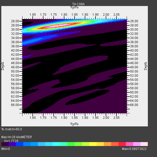
| Thickness Estimate: | 28 km |
| Thickness StdDev: | 0.2 km |
| Vp/Vs Estimate: | 1.77 |
| Vp/Vs StdDev: | 0.01 |
| Vs Estimate: | 3.622 km/s |
| Poisson's Ratio: | 0.27 |
| Peak Value: | 0.08 |
| Assumed Vp: | 6.419 km/s |
| Ps Weight: | 0.33333334 |
| PpPs Weight: | 0.33333334 |
| PsPs Weight: | 0.33333328 |
| Residual Complexity: | 0.216 |
| Nearby stations H: | +- |
| (2.0 deg) Vp/Vs: | +- |
26 with match > 90% ( 61.904762 %) and 42 with match > 80% ( 100.0 %) out of 42.
Download stack as xyz text file.
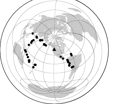
Azimuth Distribution of Events:
Prior Results for this Station
| Study | Thickness | Vp/Vs | Vp | Vs | Poissons Ratio | Extra |
| EARS | 28 km | 1.77 | 6.419 km/s | 3.622 km/s | 0.27 | |
| Crust2.0 | 39 km | 1.75 | 6.419 km/s | 3.659 km/s | 0.26 | Q2,orogen/39km no ice, Appalachians, North Andes, 0.5 km seds. |
| Global Maxima | 28 km | 1.77 | 6.419 km/s | 3.622 km/s | 0.27 | amp=0.08073922 |
| Local Maxima 1 | 29 km | 1.79 | 6.419 km/s | 3.586 km/s | 0.27 | amp=0.018682174 |
| Local Maxima 2 | 26 km | 1.87 | 6.419 km/s | 3.442 km/s | 0.30 | amp=0.014601595 |
| Local Maxima 3 | 36 km | 1.63 | 6.419 km/s | 3.944 km/s | 0.20 | amp=0.009607606 |
| Local Maxima 4 | 43 km | 1.60 | 6.419 km/s | 4.012 km/s | 0.18 | amp=0.005174923 |
| Predicted Arrivals for vertical incidence (zero ray parameter) | |
| Ps | 3.37 SECOND |
| PpPs | 12.09 SECOND |
| PsPs/PpSs | 15.46 SECOND |
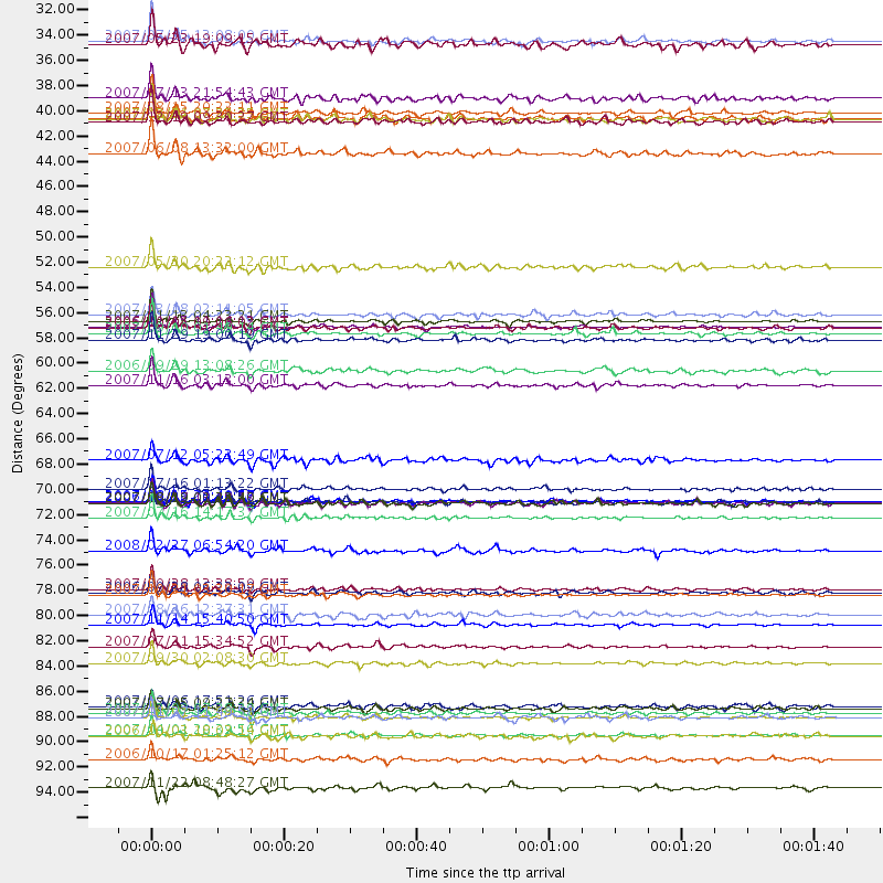
Events Processed for this Station
Download zip of receiver functions as SAC
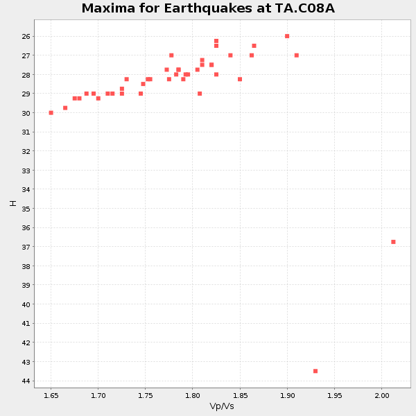
Plot maxima for each earthquake.
Events Used in the Stack
(42 events)| Radial Match | Distance | Baz | FERegion | Time | Lat/Lon | Depth | Magnitude |
| 98.607155 | 56.4 deg | 304.174 deg | Kuril Islands | 2006/11/15 11:14:13 GMT | (46.6, 153.3) | 10 km | 6.5 MB, 7.8 MS, 8.3 MW, 7.9 MW |
| 98.2168 | 71.7 deg | 136.223 deg | Near Coast Of Peru | 2007/08/15 23:40:57 GMT | (-13.4, -76.6) | 39 km | 6.7 MB, 7.9 MS, 8.0 MW, 7.5 ME |
| 97.81462 | 55.9 deg | 303.22 deg | East Of Kuril Islands | 2007/01/13 04:23:21 GMT | (46.2, 154.5) | 10 km | 7.3 MB, 8.2 MS, 8.1 MW, 7.9 MW |
| 97.07438 | 82.5 deg | 135.016 deg | Northern Chile | 2007/11/14 15:40:50 GMT | (-22.2, -69.9) | 40 km | 6.7 MB, 7.4 MS, 7.7 MW, 7.4 ME |
| 96.64126 | 90.6 deg | 247.359 deg | Vanuatu Islands | 2007/08/01 17:08:51 GMT | (-15.6, 167.7) | 120 km | 6.2 MB, 7.2 MW, 7.2 MW |
| 96.2792 | 56.9 deg | 128.448 deg | Near West Coast Of Colombia | 2007/09/10 01:49:14 GMT | (3.0, -78.0) | 31 km | 6.1 MB, 6.7 MS, 6.8 MW |
| 96.261566 | 92.1 deg | 259.853 deg | Solomon Islands | 2007/04/01 20:39:56 GMT | (-8.5, 157.0) | 10 km | 6.8 MB, 7.9 MS, 8.1 MW, 7.7 ME |
| 95.53565 | 79.4 deg | 290.874 deg | Volcano Islands, Japan Region | 2007/09/28 13:38:59 GMT | (22.0, 142.7) | 276 km | 6.7 MB, 7.4 MW, 7.4 MW |
| 95.40208 | 79.6 deg | 231.11 deg | Samoa Islands Region | 2006/09/28 06:22:09 GMT | (-16.6, -172.0) | 28 km | 6.5 MB, 6.6 MS, 6.9 MW, 6.7 MW |
| 94.91358 | 90.3 deg | 230.095 deg | South Of Fiji Islands | 2007/12/09 07:28:20 GMT | (-26.0, -177.5) | 152 km | 7.0 MB, 7.8 MW, 7.7 MW |
| 94.54481 | 79.9 deg | 286.84 deg | Mariana Islands | 2007/10/31 03:30:17 GMT | (18.9, 145.4) | 223 km | 6.2 MB, 7.2 MW, 7.2 MW |
| 94.34997 | 57.5 deg | 104.227 deg | Windward Islands | 2007/11/29 19:00:19 GMT | (15.0, -61.3) | 148 km | 6.9 MB, 7.4 MW, 7.4 MW |
| 94.111 | 73.1 deg | 306.314 deg | Sea Of Japan | 2007/07/16 14:17:37 GMT | (36.8, 134.9) | 350 km | 6.2 MB, 6.8 MW, 6.8 MW |
| 93.820755 | 61.5 deg | 131.486 deg | Peru-Ecuador Border Region | 2007/11/16 03:13:00 GMT | (-2.3, -77.8) | 123 km | 6.3 MB, 6.8 MW, 6.7 MW |
| 93.523994 | 89.9 deg | 246.818 deg | Vanuatu Islands | 2007/07/15 09:27:34 GMT | (-15.4, 168.6) | 8.0 km | 6.0 MB, 5.8 MS, 6.1 MW, 6.0 MW |
| 93.26893 | 71.7 deg | 136.326 deg | Near Coast Of Peru | 2006/10/20 10:48:56 GMT | (-13.5, -76.7) | 23 km | 5.9 MB, 6.6 MS, 6.7 MW, 6.6 MW |
| 92.934906 | 31.3 deg | 297.203 deg | Fox Islands, Aleutian Islands | 2007/07/15 13:08:00 GMT | (52.5, -168.0) | 10 km | 5.8 MB, 5.9 MS, 6.1 MW, 6.0 MW |
| 92.82003 | 51.1 deg | 308.129 deg | Kamchatka Peninsula, Russia | 2007/05/30 20:22:12 GMT | (52.1, 157.3) | 116 km | 6.4 MB, 6.4 MW, 6.4 MW |
| 92.437454 | 55.3 deg | 127.974 deg | South Of Panama | 2007/03/18 02:11:05 GMT | (4.6, -78.5) | 8.0 km | 6.4 MB, 5.7 MS, 6.2 MW, 6.1 MW |
| 92.319145 | 71.9 deg | 136.331 deg | Near Coast Of Peru | 2007/08/17 13:18:13 GMT | (-13.6, -76.6) | 48 km | 5.6 MB, 5.6 MS, 5.9 MW |
| 92.18937 | 70.6 deg | 304.644 deg | Near West Coast Of Honshu, Japan | 2007/07/16 01:13:22 GMT | (37.5, 138.4) | 12 km | 6.5 MB, 6.4 MS, 6.6 MW, 6.5 MW |
| 91.988045 | 37.6 deg | 296.317 deg | Andreanof Islands, Aleutian Is. | 2007/08/15 20:22:11 GMT | (50.3, -177.5) | 9.0 km | 6.3 MB, 6.2 MS, 6.4 MW, 5.9 ML |
| 91.487854 | 85.8 deg | 280.857 deg | South Of Mariana Islands | 2007/09/30 02:08:30 GMT | (10.5, 145.7) | 14 km | 6.4 MB, 7.1 MS, 6.9 MW, 6.9 MW |
| 90.74659 | 56.5 deg | 304.069 deg | Kuril Islands | 2006/10/01 09:06:02 GMT | (46.5, 153.2) | 19 km | 6.1 MB, 6.4 MS, 6.6 MW, 6.5 MW |
| 90.70399 | 38.4 deg | 298.587 deg | Andreanof Islands, Aleutian Is. | 2007/12/19 09:30:27 GMT | (51.4, -179.5) | 29 km | 6.4 MB, 7.1 MS, 7.1 MW, 7.0 MW |
| 90.55374 | 71.8 deg | 305.625 deg | Near West Coast Of Honshu, Japan | 2007/03/25 00:41:57 GMT | (37.3, 136.6) | 8.0 km | 6.1 MB, 6.8 MS, 6.7 MW, 6.6 MW |
| 88.96295 | 36.3 deg | 298.302 deg | Andreanof Islands, Aleutian Is. | 2007/07/13 21:54:43 GMT | (51.8, -176.3) | 35 km | 5.7 MB, 5.6 MS, 6.0 MW, 5.9 MW |
| 87.65859 | 71.9 deg | 136.356 deg | Near Coast Of Peru | 2007/08/19 01:22:40 GMT | (-13.6, -76.6) | 26 km | 5.9 MB, 5.4 MS, 5.8 MW, 5.5 ML |
| 87.20089 | 41.2 deg | 135.687 deg | Near Coast Of Guatemala | 2007/06/08 13:32:00 GMT | (13.8, -90.8) | 48 km | 5.5 MB, 5.4 MS, 5.8 MW, 5.8 MW |
| 86.230675 | 84.4 deg | 131.71 deg | Jujuy Province, Argentina | 2007/07/21 15:34:52 GMT | (-22.2, -65.8) | 290 km | 5.8 MB, 6.4 MW, 6.3 MW |
| 84.77301 | 60.2 deg | 107.81 deg | Trinidad | 2006/09/29 13:08:26 GMT | (10.9, -61.8) | 53 km | 5.9 MB, 5.4 MS, 6.1 MW, 6.0 MW |
| 83.62391 | 94.3 deg | 266.033 deg | New Britain Region, P.N.G. | 2006/10/17 01:25:12 GMT | (-5.9, 151.0) | 32 km | 6.4 MB, 6.9 MS, 6.7 MW, 6.6 MW |
| 82.19688 | 68.0 deg | 131.342 deg | Peru-Brazil Border Region | 2007/07/12 05:23:49 GMT | (-7.9, -74.4) | 152 km | 5.9 MB, 6.1 MW, 6.0 MW |
| 81.75755 | 31.6 deg | 136.894 deg | Gulf Of Mexico | 2007/05/23 19:09:15 GMT | (21.9, -96.4) | 10 km | 5.6 MW, 4.8 MS, 5.4 MB |
| 81.64981 | 38.1 deg | 298.235 deg | Andreanof Islands, Aleutian Is. | 2007/12/21 07:23:35 GMT | (51.2, -179.0) | 30 km | 5.7 MB, 5.5 ML |
| 81.55497 | 38.1 deg | 298.401 deg | Andreanof Islands, Aleutian Is. | 2007/12/21 07:24:34 GMT | (51.4, -179.0) | 30 km | 6.1 MB, 6.2 MW, 6.3 ML |
| 81.339806 | 76.0 deg | 294.369 deg | Bonin Islands, Japan Region | 2008/02/27 06:54:20 GMT | (26.8, 142.4) | 15 km | 5.8 MB, 6.1 MS, 6.2 MW, 6.2 MW |
| 81.24521 | 81.6 deg | 232.485 deg | Tonga Islands | 2007/08/26 12:37:31 GMT | (-17.5, -174.3) | 127 km | 5.9 MB, 6.1 MW |
| 80.98202 | 89.6 deg | 306.886 deg | Taiwan Region | 2007/09/06 17:51:26 GMT | (24.3, 122.2) | 53 km | 6.1 MB, 6.2 MW, 6.1 ME |
| 80.79322 | 90.6 deg | 254.451 deg | Solomon Islands | 2007/11/27 11:49:58 GMT | (-10.9, 162.1) | 16 km | 5.9 MB, 6.7 MS, 6.6 MW, 6.4 MW |
| 80.19266 | 96.8 deg | 268.974 deg | Eastern New Guinea Reg., P.N.G. | 2007/11/22 08:48:27 GMT | (-5.8, 147.1) | 53 km | 6.0 MB, 6.7 MW, 6.7 MW |
| 80.182846 | 92.3 deg | 244.294 deg | Vanuatu Islands | 2006/10/03 18:03:14 GMT | (-18.9, 169.0) | 171 km | 5.9 MB, 6.3 MW, 6.3 MW |
Losers
(0 events)| Radial Match | Distance | Baz | FERegion | Time | Lat/Lon | Depth | Magnitude | Reason |
