You are here: Home > Network List > TA - USArray Transportable Network (new EarthScope stations) Stations List
> Station C08A Higginbotham Farm, Almira, WA, USA > Earthquake Result Viewer
C08A Higginbotham Farm, Almira, WA, USA - Earthquake Result Viewer
| Earthquake location: |
Eastern New Guinea Reg., P.N.G. |
| Earthquake latitude/longitude: |
-5.8/147.1 |
| Earthquake time(UTC): |
2007/11/22 (326) 08:48:27 GMT |
| Earthquake Depth: |
53 km |
| Earthquake Magnitude: |
6.0 MB, 6.7 MW, 6.7 MW |
| Earthquake Catalog/Contributor: |
WHDF/NEIC |
|
| Network: |
TA USArray Transportable Network (new EarthScope stations) |
| Station: |
C08A Higginbotham Farm, Almira, WA, USA |
| Lat/Lon: |
47.78 N/119.05 W |
| Elevation: |
783 m |
|
| Distance: |
96.8 deg |
| Az: |
42.661 deg |
| Baz: |
268.974 deg |
| Ray Param: |
0.04036663 |
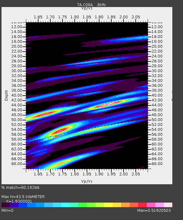
| Estimated Moho Depth: |
43.5 km |
| Estimated Crust Vp/Vs: |
1.93 |
| Assumed Crust Vp: |
6.419 km/s |
| Estimated Crust Vs: |
3.326 km/s |
| Estimated Crust Poisson's Ratio: |
0.32 |
|
| Radial Match: |
80.19266 % |
| Radial Bump: |
316 |
| Transverse Match: |
53.89457 % |
| Transverse Bump: |
400 |
| SOD ConfigId: |
2564 |
| Insert Time: |
2010-03-07 03:20:18.253 +0000 |
| GWidth: |
2.5 |
| Max Bumps: |
400 |
| Tol: |
0.001 |
|

Signal To Noise
| Channel | StoN | STA | LTA |
| TA:C08A: :BHN:20071122T09:01:21.225007Z | 0.32086456 | 1.2947544E-7 | 4.0352052E-7 |
| TA:C08A: :BHE:20071122T09:01:21.225007Z | 1.271192 | 5.0495686E-7 | 3.9723105E-7 |
| TA:C08A: :BHZ:20071122T09:01:21.225007Z | 1.8151028 | 8.6182524E-7 | 4.7480796E-7 |
| Arrivals |
| Ps | 6.4 SECOND |
| PpPs | 20 SECOND |
| PsPs/PpSs | 26 SECOND |


