You are here: Home > Network List > TA - USArray Transportable Network (new EarthScope stations) Stations List
> Station C08A Higginbotham Farm, Almira, WA, USA > Earthquake Result Viewer
C08A Higginbotham Farm, Almira, WA, USA - Earthquake Result Viewer
| Earthquake location: |
Near West Coast Of Colombia |
| Earthquake latitude/longitude: |
3.0/-78.0 |
| Earthquake time(UTC): |
2007/09/10 (253) 01:49:14 GMT |
| Earthquake Depth: |
31 km |
| Earthquake Magnitude: |
6.1 MB, 6.7 MS, 6.8 MW |
| Earthquake Catalog/Contributor: |
WHDF/NEIC |
|
| Network: |
TA USArray Transportable Network (new EarthScope stations) |
| Station: |
C08A Higginbotham Farm, Almira, WA, USA |
| Lat/Lon: |
47.78 N/119.05 W |
| Elevation: |
783 m |
|
| Distance: |
56.9 deg |
| Az: |
328.071 deg |
| Baz: |
128.448 deg |
| Ray Param: |
0.06377371 |
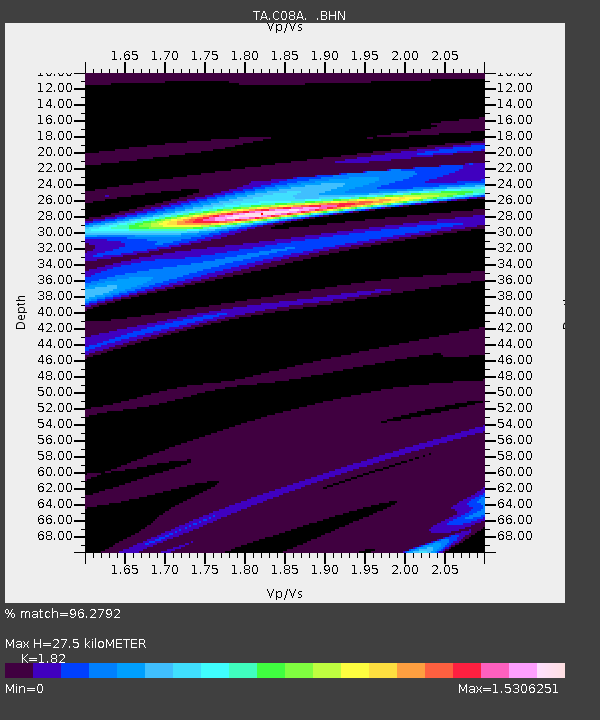
| Estimated Moho Depth: |
27.5 km |
| Estimated Crust Vp/Vs: |
1.82 |
| Assumed Crust Vp: |
6.419 km/s |
| Estimated Crust Vs: |
3.527 km/s |
| Estimated Crust Poisson's Ratio: |
0.28 |
|
| Radial Match: |
96.2792 % |
| Radial Bump: |
282 |
| Transverse Match: |
86.22001 % |
| Transverse Bump: |
400 |
| SOD ConfigId: |
2564 |
| Insert Time: |
2010-03-07 03:20:30.334 +0000 |
| GWidth: |
2.5 |
| Max Bumps: |
400 |
| Tol: |
0.001 |
|

Signal To Noise
| Channel | StoN | STA | LTA |
| TA:C08A: :BHN:20070910T01:58:25.550017Z | 4.9235835 | 5.6010833E-7 | 1.13760294E-7 |
| TA:C08A: :BHE:20070910T01:58:25.550017Z | 4.2348237 | 6.3846437E-7 | 1.5076527E-7 |
| TA:C08A: :BHZ:20070910T01:58:25.550017Z | 12.142543 | 1.4410141E-6 | 1.1867482E-7 |
| Arrivals |
| Ps | 3.7 SECOND |
| PpPs | 12 SECOND |
| PsPs/PpSs | 15 SECOND |


