You are here: Home > Network List > TA - USArray Transportable Network (new EarthScope stations) Stations List
> Station C08A Higginbotham Farm, Almira, WA, USA > Earthquake Result Viewer
C08A Higginbotham Farm, Almira, WA, USA - Earthquake Result Viewer
| Earthquake location: |
Near Coast Of Peru |
| Earthquake latitude/longitude: |
-13.4/-76.6 |
| Earthquake time(UTC): |
2007/08/15 (227) 23:40:57 GMT |
| Earthquake Depth: |
39 km |
| Earthquake Magnitude: |
6.7 MB, 7.9 MS, 8.0 MW, 7.5 ME |
| Earthquake Catalog/Contributor: |
WHDF/NEIC |
|
| Network: |
TA USArray Transportable Network (new EarthScope stations) |
| Station: |
C08A Higginbotham Farm, Almira, WA, USA |
| Lat/Lon: |
47.78 N/119.05 W |
| Elevation: |
783 m |
|
| Distance: |
71.7 deg |
| Az: |
331.352 deg |
| Baz: |
136.223 deg |
| Ray Param: |
0.054106254 |
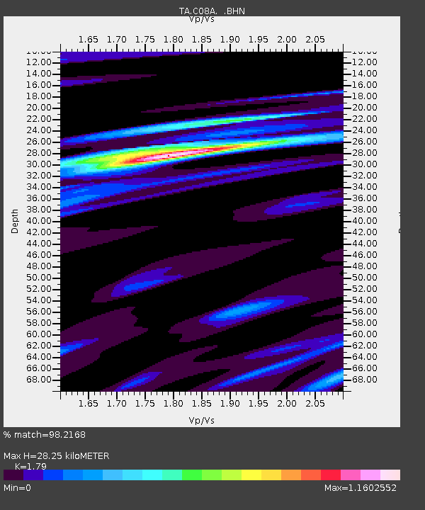
| Estimated Moho Depth: |
28.25 km |
| Estimated Crust Vp/Vs: |
1.79 |
| Assumed Crust Vp: |
6.419 km/s |
| Estimated Crust Vs: |
3.586 km/s |
| Estimated Crust Poisson's Ratio: |
0.27 |
|
| Radial Match: |
98.2168 % |
| Radial Bump: |
251 |
| Transverse Match: |
89.1619 % |
| Transverse Bump: |
400 |
| SOD ConfigId: |
2564 |
| Insert Time: |
2010-03-07 03:20:40.306 +0000 |
| GWidth: |
2.5 |
| Max Bumps: |
400 |
| Tol: |
0.001 |
|

Signal To Noise
| Channel | StoN | STA | LTA |
| TA:C08A: :BHN:20070815T23:51:44.749009Z | 17.335773 | 1.3309783E-6 | 7.67764E-8 |
| TA:C08A: :BHE:20070815T23:51:44.749009Z | 9.315829 | 1.0718595E-6 | 1.1505787E-7 |
| TA:C08A: :BHZ:20070815T23:51:44.749009Z | 30.3911 | 3.7735929E-6 | 1.241677E-7 |
| Arrivals |
| Ps | 3.6 SECOND |
| PpPs | 12 SECOND |
| PsPs/PpSs | 15 SECOND |


