You are here: Home > Network List > TA - USArray Transportable Network (new EarthScope stations) Stations List
> Station C08A Higginbotham Farm, Almira, WA, USA > Earthquake Result Viewer
C08A Higginbotham Farm, Almira, WA, USA - Earthquake Result Viewer
| Earthquake location: |
Kuril Islands |
| Earthquake latitude/longitude: |
46.6/153.3 |
| Earthquake time(UTC): |
2006/11/15 (319) 11:14:13 GMT |
| Earthquake Depth: |
10 km |
| Earthquake Magnitude: |
6.5 MB, 7.8 MS, 8.3 MW, 7.9 MW |
| Earthquake Catalog/Contributor: |
WHDF/NEIC |
|
| Network: |
TA USArray Transportable Network (new EarthScope stations) |
| Station: |
C08A Higginbotham Farm, Almira, WA, USA |
| Lat/Lon: |
47.78 N/119.05 W |
| Elevation: |
783 m |
|
| Distance: |
56.4 deg |
| Az: |
54.004 deg |
| Baz: |
304.174 deg |
| Ray Param: |
0.06417011 |
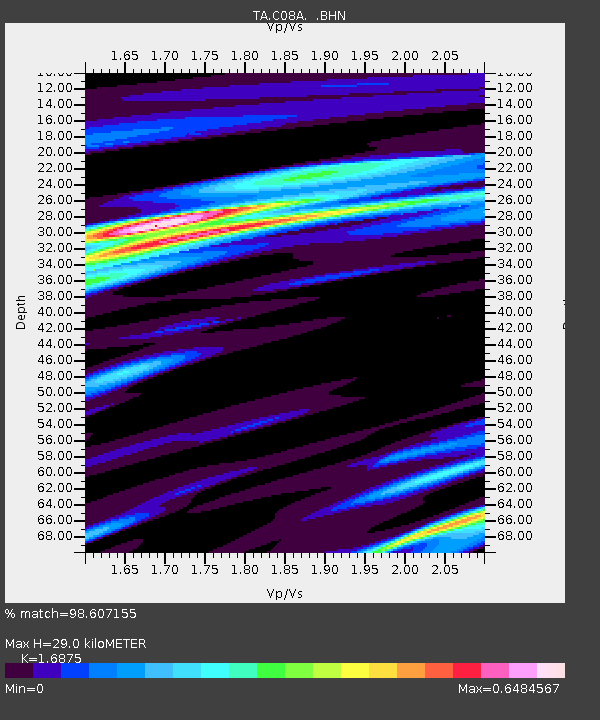
| Estimated Moho Depth: |
29.0 km |
| Estimated Crust Vp/Vs: |
1.69 |
| Assumed Crust Vp: |
6.419 km/s |
| Estimated Crust Vs: |
3.804 km/s |
| Estimated Crust Poisson's Ratio: |
0.23 |
|
| Radial Match: |
98.607155 % |
| Radial Bump: |
239 |
| Transverse Match: |
92.110825 % |
| Transverse Bump: |
400 |
| SOD ConfigId: |
2564 |
| Insert Time: |
2010-03-07 03:21:12.415 +0000 |
| GWidth: |
2.5 |
| Max Bumps: |
400 |
| Tol: |
0.001 |
|

Signal To Noise
| Channel | StoN | STA | LTA |
| TA:C08A: :BHN:20061115T11:23:23.924004Z | 2.1521673 | 7.1901286E-7 | 3.3408782E-7 |
| TA:C08A: :BHE:20061115T11:23:23.924004Z | 2.6918302 | 7.860487E-7 | 2.9201274E-7 |
| TA:C08A: :BHZ:20061115T11:23:23.924004Z | 4.9053807 | 1.6859675E-6 | 3.436976E-7 |
| Arrivals |
| Ps | 3.3 SECOND |
| PpPs | 12 SECOND |
| PsPs/PpSs | 15 SECOND |


