You are here: Home > Network List > TA - USArray Transportable Network (new EarthScope stations) Stations List
> Station C08A Higginbotham Farm, Almira, WA, USA > Earthquake Result Viewer
C08A Higginbotham Farm, Almira, WA, USA - Earthquake Result Viewer
| Earthquake location: |
Samoa Islands Region |
| Earthquake latitude/longitude: |
-16.6/-172.0 |
| Earthquake time(UTC): |
2006/09/28 (271) 06:22:09 GMT |
| Earthquake Depth: |
28 km |
| Earthquake Magnitude: |
6.5 MB, 6.6 MS, 6.9 MW, 6.7 MW |
| Earthquake Catalog/Contributor: |
WHDF/NEIC |
|
| Network: |
TA USArray Transportable Network (new EarthScope stations) |
| Station: |
C08A Higginbotham Farm, Almira, WA, USA |
| Lat/Lon: |
47.78 N/119.05 W |
| Elevation: |
783 m |
|
| Distance: |
79.6 deg |
| Az: |
33.19 deg |
| Baz: |
231.11 deg |
| Ray Param: |
0.04878346 |
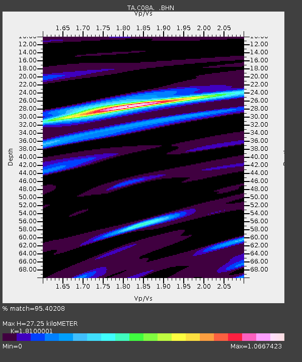
| Estimated Moho Depth: |
27.25 km |
| Estimated Crust Vp/Vs: |
1.81 |
| Assumed Crust Vp: |
6.419 km/s |
| Estimated Crust Vs: |
3.547 km/s |
| Estimated Crust Poisson's Ratio: |
0.28 |
|
| Radial Match: |
95.40208 % |
| Radial Bump: |
400 |
| Transverse Match: |
84.26414 % |
| Transverse Bump: |
400 |
| SOD ConfigId: |
2665 |
| Insert Time: |
2010-03-07 03:21:22.771 +0000 |
| GWidth: |
2.5 |
| Max Bumps: |
400 |
| Tol: |
0.001 |
|

Signal To Noise
| Channel | StoN | STA | LTA |
| TA:C08A: :BHN:20060928T06:33:43.300007Z | 8.434305 | 9.240113E-7 | 1.0955393E-7 |
| TA:C08A: :BHE:20060928T06:33:43.300007Z | 12.220067 | 1.3699325E-6 | 1.12105155E-7 |
| TA:C08A: :BHZ:20060928T06:33:43.300007Z | 24.175001 | 4.249739E-6 | 1.7579065E-7 |
| Arrivals |
| Ps | 3.5 SECOND |
| PpPs | 12 SECOND |
| PsPs/PpSs | 15 SECOND |


