You are here: Home > Network List > TA - USArray Transportable Network (new EarthScope stations) Stations List
> Station Y22C IRIS PASSCAL Instrument Center, Socorro NM, USA > Earthquake Result Viewer
Y22C IRIS PASSCAL Instrument Center, Socorro NM, USA - Earthquake Result Viewer
| Earthquake location: |
Chile-Bolivia Border Region |
| Earthquake latitude/longitude: |
-22.3/-67.9 |
| Earthquake time(UTC): |
2005/11/17 (321) 19:26:56 GMT |
| Earthquake Depth: |
163 km |
| Earthquake Magnitude: |
6.0 MB, 6.9 MW, 6.8 MW |
| Earthquake Catalog/Contributor: |
WHDF/NEIC |
|
| Network: |
TA USArray Transportable Network (new EarthScope stations) |
| Station: |
Y22C IRIS PASSCAL Instrument Center, Socorro NM, USA |
| Lat/Lon: |
34.07 N/106.92 W |
| Elevation: |
1436 m |
|
| Distance: |
67.3 deg |
| Az: |
325.473 deg |
| Baz: |
140.781 deg |
| Ray Param: |
0.056615323 |
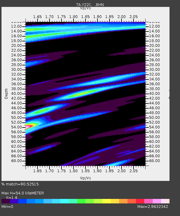
| Estimated Moho Depth: |
54.0 km |
| Estimated Crust Vp/Vs: |
1.60 |
| Assumed Crust Vp: |
6.502 km/s |
| Estimated Crust Vs: |
4.063 km/s |
| Estimated Crust Poisson's Ratio: |
0.18 |
|
| Radial Match: |
90.52515 % |
| Radial Bump: |
387 |
| Transverse Match: |
77.867714 % |
| Transverse Bump: |
367 |
| SOD ConfigId: |
2422 |
| Insert Time: |
2010-03-07 03:23:34.500 +0000 |
| GWidth: |
2.5 |
| Max Bumps: |
400 |
| Tol: |
0.001 |
|

Signal To Noise
| Channel | StoN | STA | LTA |
| TA:Y22C: :BHN:20051117T19:37:02.57502Z | 1.7281731 | 1.372791E-6 | 7.9435966E-7 |
| TA:Y22C: :BHE:20051117T19:37:02.57502Z | 1.8620002 | 1.092257E-6 | 5.8660413E-7 |
| TA:Y22C: :BHZ:20051117T19:37:02.57502Z | 16.289106 | 5.5992655E-6 | 3.4374293E-7 |
| Arrivals |
| Ps | 5.2 SECOND |
| PpPs | 21 SECOND |
| PsPs/PpSs | 26 SECOND |


