
Station TA Y22C - IRIS PASSCAL Instrument Center, Socorro NM, USA
Network: TA - USArray Transportable Network (new EarthScope stations)
Nearby stations (2 deg radius)
| Station | Name | (Lat, Lon) | Start / End | Elevation |
| Y22C | IRIS PASSCAL Instrument Center, Socorro NM, USA | (34.07, -106.92) | 2004-05-07 / 2499-01-01 | 1436 m |
| Crust2 Type: | X2,Rift, Rio Grande, Baikal, 0.5km sediments |
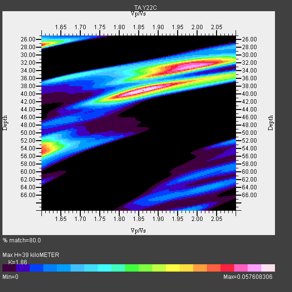
| Thickness Estimate: | 39 km |
| Thickness StdDev: | 7.7 km |
| Vp/Vs Estimate: | 1.86 |
| Vp/Vs StdDev: | 0.14 |
| Vs Estimate: | 3.495 km/s |
| Poisson's Ratio: | 0.30 |
| Peak Value: | 0.06 |
| Assumed Vp: | 6.502 km/s |
| Ps Weight: | 0.33333334 |
| PpPs Weight: | 0.33333334 |
| PsPs Weight: | 0.33333328 |
| Residual Complexity: | 0.742 |
| Nearby stations H: | 40 km +- 0.6 km |
| (2.0 deg) Vp/Vs: | 1.77 +- 0.13 |
5 with match > 90% ( 17.857143 %) and 28 with match > 80% ( 100.0 %) out of 28.
Download stack as xyz text file.
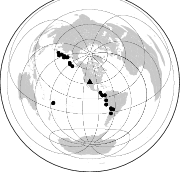
Azimuth Distribution of Events:
Prior Results for this Station
| Study | Thickness | Vp/Vs | Vp | Vs | Poissons Ratio | Extra |
| EARS | 39 km | 1.86 | 6.502 km/s | 3.495 km/s | 0.30 | |
| Crust2.0 | 33 km | 1.77 | 6.502 km/s | 3.68 km/s | 0.26 | X2,Rift, Rio Grande, Baikal, 0.5km sediments |
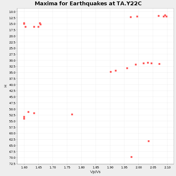
| Global Maxima | 39 km | 1.86 | 6.502 km/s | 3.495 km/s | 0.30 | amp=0.057608306 |
| Local Maxima 1 | 27 km | 1.60 | 6.502 km/s | 4.063 km/s | 0.18 | amp=0.04762626 |
| Local Maxima 2 | 55 km | 1.60 | 6.502 km/s | 4.063 km/s | 0.18 | amp=0.045301445 |
| Local Maxima 3 | 32 km | 1.95 | 6.502 km/s | 3.334 km/s | 0.32 | amp=0.041687284 |
| Local Maxima 4 | 54 km | 1.60 | 6.502 km/s | 4.063 km/s | 0.18 | amp=0.032406352 |
| Predicted Arrivals for vertical incidence (zero ray parameter) | |
| Ps | 5.16 SECOND |
| PpPs | 17.16 SECOND |
| PsPs/PpSs | 22.31 SECOND |
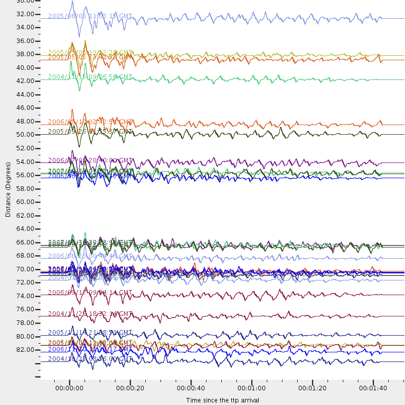
Events Processed for this Station
Download zip of receiver functions as SAC
Plot maxima for each earthquake.
Events Used in the Stack
(28 events)| Radial Match | Distance | Baz | FERegion | Time | Lat/Lon | Depth | Magnitude |
| 93.557655 | 72.2 deg | 314.452 deg | Kuril Islands | 2006/11/15 11:14:13 GMT | (46.6, 153.3) | 10 km | 6.5 MB, 7.8 MS, 8.3 MW, 7.9 MW |
| 91.29186 | 40.0 deg | 130.408 deg | Near West Coast Of Colombia | 2004/11/15 09:06:56 GMT | (4.7, -77.5) | 15 km | 6.6 MB, 7.1 MS, 7.2 MW, 7.1 MW |
| 91.140526 | 55.3 deg | 143.434 deg | Near Coast Of Peru | 2006/10/20 10:48:56 GMT | (-13.5, -76.7) | 23 km | 5.9 MB, 6.6 MS, 6.7 MW, 6.6 MW |
| 90.52515 | 67.3 deg | 140.781 deg | Chile-Bolivia Border Region | 2005/11/17 19:26:56 GMT | (-22.3, -67.9) | 163 km | 6.0 MB, 6.9 MW, 6.8 MW |
| 90.333115 | 30.0 deg | 134.267 deg | Nicaragua | 2005/08/03 11:03:15 GMT | (11.2, -85.5) | 14 km | 6.0 MB, 6.5 MS, 6.3 MW, 6.3 MW |
| 89.80025 | 82.0 deg | 310.821 deg | Off East Coast Of Honshu, Japan | 2005/11/14 21:38:51 GMT | (38.1, 144.9) | 11 km | 6.7 MB, 6.8 MS, 7.0 MW, 6.9 MW |
| 88.78669 | 48.9 deg | 137.915 deg | Northern Peru | 2005/09/26 01:55:37 GMT | (-5.7, -76.4) | 115 km | 6.7 MB, 7.5 MW, 7.5 MW |
| 88.598236 | 71.6 deg | 313.671 deg | East Of Kuril Islands | 2007/01/13 04:23:21 GMT | (46.2, 154.5) | 10 km | 7.3 MB, 8.2 MS, 8.1 MW, 7.9 MW |
| 88.308655 | 47.4 deg | 312.661 deg | Fox Islands, Aleutian Islands | 2006/05/10 02:42:51 GMT | (52.5, -169.3) | 18 km | 6.1 MB, 6.2 MS, 6.4 MW, 6.3 MW |
| 87.65803 | 73.0 deg | 315.727 deg | Kuril Islands | 2004/07/08 10:30:49 GMT | (47.2, 151.3) | 128 km | 5.9 MB, 6.4 MW, 6.3 MW |
| 87.213234 | 67.5 deg | 317.273 deg | Near East Coast Of Kamchatka | 2006/08/24 21:50:36 GMT | (51.1, 157.5) | 43 km | 5.9 MB, 6.2 MS, 6.5 MW, 6.5 MW |
| 86.459145 | 69.4 deg | 141.35 deg | Chile-Argentina Border Region | 2006/08/25 00:44:46 GMT | (-24.4, -67.0) | 184 km | 5.9 MB, 6.6 MW, 6.6 MW |
| 86.17825 | 83.6 deg | 240.61 deg | Tonga Islands | 2006/05/03 15:26:40 GMT | (-20.2, -174.1) | 55 km | 7.2 MB, 7.8 MS, 7.9 MW, 7.9 MW |
| 85.756546 | 83.8 deg | 312.164 deg | Near East Coast Of Honshu, Japan | 2005/12/02 13:13:09 GMT | (38.1, 142.1) | 29 km | 6.1 MB, 6.3 MS, 6.5 MW, 6.4 MW |
| 85.60028 | 71.7 deg | 313.64 deg | East Of Kuril Islands | 2006/12/07 19:10:21 GMT | (46.2, 154.4) | 16 km | 6.3 MB, 6.1 MS, 6.3 MW, 6.3 MW |
| 85.41079 | 86.4 deg | 313.202 deg | Near West Coast Of Honshu, Japan | 2004/10/23 08:56:00 GMT | (37.2, 138.8) | 16 km | 6.4 MB, 6.3 MS, 6.6 MW, 6.4 MW |
| 85.343155 | 71.8 deg | 138.924 deg | Salta Province, Argentina | 2005/03/21 12:23:54 GMT | (-25.0, -63.5) | 579 km | 6.1 MB, 6.9 MW, 6.9 MW |
| 85.17374 | 36.7 deg | 136.292 deg | South Of Panama | 2005/05/05 23:41:53 GMT | (5.1, -82.4) | 10 km | 5.7 MB, 5.0 MS, 5.9 MW, 5.8 MW |
| 85.126854 | 53.7 deg | 311.969 deg | Andreanof Islands, Aleutian Is. | 2006/07/08 20:40:00 GMT | (51.2, -179.3) | 22 km | 6.2 MB, 6.4 MS, 6.6 MW, 6.6 MW |
| 84.491714 | 79.0 deg | 314.688 deg | Hokkaido, Japan Region | 2004/11/28 18:32:14 GMT | (43.0, 145.1) | 39 km | 6.4 MB, 6.7 MS, 7.0 MW, 7.0 MW |
| 84.24119 | 55.5 deg | 143.477 deg | Near Coast Of Peru | 2007/08/19 01:22:40 GMT | (-13.6, -76.6) | 26 km | 5.9 MB, 5.4 MS, 5.8 MW, 5.5 ML |
| 82.61957 | 36.0 deg | 136.265 deg | South Of Panama | 2005/05/05 19:12:20 GMT | (5.7, -82.8) | 10 km | 5.9 MB, 5.8 MS, 6.5 MW, 6.4 MW |
| 81.64758 | 71.6 deg | 313.796 deg | East Of Kuril Islands | 2006/11/16 06:20:20 GMT | (46.4, 154.5) | 9.0 km | 6.0 MB, 5.4 MS, 5.9 MW, 5.9 MW |
| 81.55372 | 72.2 deg | 314.351 deg | Kuril Islands | 2006/10/01 09:06:02 GMT | (46.5, 153.2) | 19 km | 6.1 MB, 6.4 MS, 6.6 MW, 6.5 MW |
| 81.05255 | 75.4 deg | 145.746 deg | San Juan Province, Argentina | 2006/09/17 09:34:14 GMT | (-31.7, -67.2) | 142 km | 5.7 MB, 6.2 MW, 6.2 MW |
| 80.817505 | 67.2 deg | 318.302 deg | Kamchatka Peninsula, Russia | 2007/05/30 20:22:12 GMT | (52.1, 157.3) | 116 km | 6.4 MB, 6.4 MW, 6.4 MW |
| 80.75592 | 56.3 deg | 313.882 deg | Rat Islands, Aleutian Islands | 2006/06/27 02:39:35 GMT | (52.2, 176.2) | 34 km | 5.6 MB, 6.0 MS, 6.2 MW, 6.2 MW |
| 80.63636 | 84.7 deg | 240.087 deg | Tonga Islands | 2006/11/30 11:33:17 GMT | (-21.3, -174.7) | 14 km | 5.7 MB, 6.1 MS, 6.0 MW, 6.0 MW |
Losers
(0 events)| Radial Match | Distance | Baz | FERegion | Time | Lat/Lon | Depth | Magnitude | Reason |
