You are here: Home > Network List > TA - USArray Transportable Network (new EarthScope stations) Stations List
> Station Y22C IRIS PASSCAL Instrument Center, Socorro NM, USA > Earthquake Result Viewer
Y22C IRIS PASSCAL Instrument Center, Socorro NM, USA - Earthquake Result Viewer
| Earthquake location: |
East Of Kuril Islands |
| Earthquake latitude/longitude: |
46.2/154.5 |
| Earthquake time(UTC): |
2007/01/13 (013) 04:23:21 GMT |
| Earthquake Depth: |
10 km |
| Earthquake Magnitude: |
7.3 MB, 8.2 MS, 8.1 MW, 7.9 MW |
| Earthquake Catalog/Contributor: |
WHDF/NEIC |
|
| Network: |
TA USArray Transportable Network (new EarthScope stations) |
| Station: |
Y22C IRIS PASSCAL Instrument Center, Socorro NM, USA |
| Lat/Lon: |
34.07 N/106.92 W |
| Elevation: |
1436 m |
|
| Distance: |
71.6 deg |
| Az: |
59.893 deg |
| Baz: |
313.671 deg |
| Ray Param: |
0.05422657 |
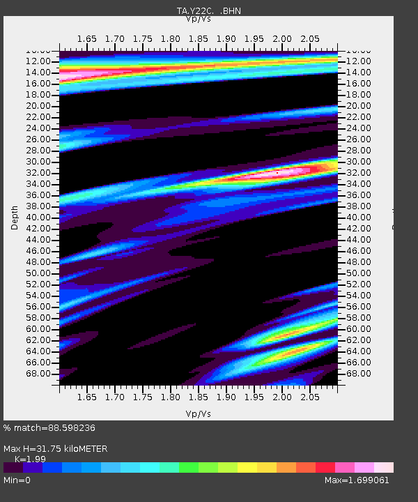
| Estimated Moho Depth: |
31.75 km |
| Estimated Crust Vp/Vs: |
1.99 |
| Assumed Crust Vp: |
6.502 km/s |
| Estimated Crust Vs: |
3.267 km/s |
| Estimated Crust Poisson's Ratio: |
0.33 |
|
| Radial Match: |
88.598236 % |
| Radial Bump: |
400 |
| Transverse Match: |
87.22727 % |
| Transverse Bump: |
400 |
| SOD ConfigId: |
2564 |
| Insert Time: |
2010-03-07 03:23:45.926 +0000 |
| GWidth: |
2.5 |
| Max Bumps: |
400 |
| Tol: |
0.001 |
|

Signal To Noise
| Channel | StoN | STA | LTA |
| TA:Y22C: :BHN:20070113T04:34:11.250027Z | 2.5195715 | 8.6235804E-7 | 3.4226377E-7 |
| TA:Y22C: :BHE:20070113T04:34:11.250027Z | 1.1430123 | 7.7707654E-7 | 6.798497E-7 |
| TA:Y22C: :BHZ:20070113T04:34:11.250027Z | 13.76091 | 2.3453265E-6 | 1.7043396E-7 |
| Arrivals |
| Ps | 5.0 SECOND |
| PpPs | 14 SECOND |
| PsPs/PpSs | 19 SECOND |


