You are here: Home > Network List > TA - USArray Transportable Network (new EarthScope stations) Stations List
> Station Y22C IRIS PASSCAL Instrument Center, Socorro NM, USA > Earthquake Result Viewer
Y22C IRIS PASSCAL Instrument Center, Socorro NM, USA - Earthquake Result Viewer
| Earthquake location: |
Near Coast Of Peru |
| Earthquake latitude/longitude: |
-13.5/-76.7 |
| Earthquake time(UTC): |
2006/10/20 (293) 10:48:56 GMT |
| Earthquake Depth: |
23 km |
| Earthquake Magnitude: |
5.9 MB, 6.6 MS, 6.7 MW, 6.6 MW |
| Earthquake Catalog/Contributor: |
WHDF/NEIC |
|
| Network: |
TA USArray Transportable Network (new EarthScope stations) |
| Station: |
Y22C IRIS PASSCAL Instrument Center, Socorro NM, USA |
| Lat/Lon: |
34.07 N/106.92 W |
| Elevation: |
1436 m |
|
| Distance: |
55.3 deg |
| Az: |
329.451 deg |
| Baz: |
143.434 deg |
| Ray Param: |
0.0648237 |
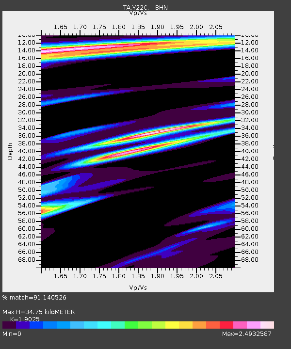
| Estimated Moho Depth: |
34.75 km |
| Estimated Crust Vp/Vs: |
1.90 |
| Assumed Crust Vp: |
6.502 km/s |
| Estimated Crust Vs: |
3.417 km/s |
| Estimated Crust Poisson's Ratio: |
0.31 |
|
| Radial Match: |
91.140526 % |
| Radial Bump: |
382 |
| Transverse Match: |
83.41017 % |
| Transverse Bump: |
400 |
| SOD ConfigId: |
2665 |
| Insert Time: |
2010-03-07 03:24:00.109 +0000 |
| GWidth: |
2.5 |
| Max Bumps: |
400 |
| Tol: |
0.001 |
|
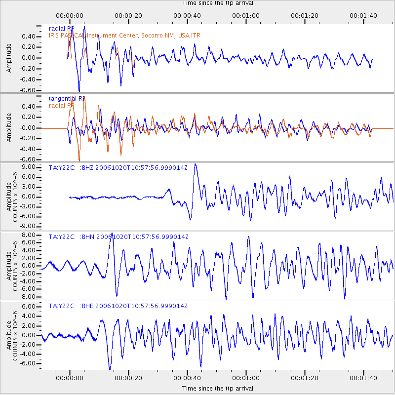
Signal To Noise
| Channel | StoN | STA | LTA |
| TA:Y22C: :BHN:20061020T10:57:56.999014Z | 1.4987036 | 9.214091E-7 | 6.1480404E-7 |
| TA:Y22C: :BHE:20061020T10:57:56.999014Z | 0.81010973 | 3.983042E-7 | 4.91667E-7 |
| TA:Y22C: :BHZ:20061020T10:57:56.999014Z | 4.888389 | 1.1446687E-6 | 2.3416072E-7 |
| Arrivals |
| Ps | 5.1 SECOND |
| PpPs | 15 SECOND |
| PsPs/PpSs | 20 SECOND |


