You are here: Home > Network List > TA - USArray Transportable Network (new EarthScope stations) Stations List
> Station Y22C IRIS PASSCAL Instrument Center, Socorro NM, USA > Earthquake Result Viewer
Y22C IRIS PASSCAL Instrument Center, Socorro NM, USA - Earthquake Result Viewer

| Earthquake location: |
Hokkaido, Japan Region |
| Earthquake latitude/longitude: |
43.0/145.1 |
| Earthquake time(UTC): |
2004/11/28 (333) 18:32:14 GMT |
| Earthquake Depth: |
39 km |
| Earthquake Magnitude: |
6.4 MB, 6.7 MS, 7.0 MW, 7.0 MW |
| Earthquake Catalog/Contributor: |
WHDF/NEIC |
|
| Network: |
TA USArray Transportable Network (new EarthScope stations) |
| Station: |
Y22C IRIS PASSCAL Instrument Center, Socorro NM, USA |
| Lat/Lon: |
34.07 N/106.92 W |
| Elevation: |
1436 m |
|
| Distance: |
79.0 deg |
| Az: |
53.558 deg |
| Baz: |
314.688 deg |
| Ray Param: |
0.04921837 |
| Estimated Moho Depth: |
31.25 km |
| Estimated Crust Vp/Vs: |
2.02 |
| Assumed Crust Vp: |
6.502 km/s |
| Estimated Crust Vs: |
3.223 km/s |
| Estimated Crust Poisson's Ratio: |
0.34 |
|
| Radial Match: |
84.491714 % |
| Radial Bump: |
400 |
| Transverse Match: |
67.34952 % |
| Transverse Bump: |
400 |
| SOD ConfigId: |
2459 |
| Insert Time: |
2010-03-07 03:24:19.440 +0000 |
| GWidth: |
2.5 |
| Max Bumps: |
400 |
| Tol: |
0.001 |
|
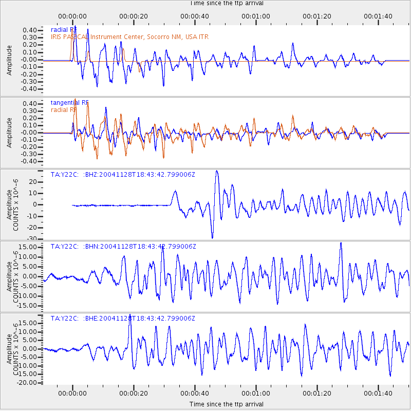
Signal To Noise
| Channel | StoN | STA | LTA |
| TA:Y22C: :BHN:20041128T18:43:42.799006Z | 1.4662877 | 1.3979866E-6 | 9.53419E-7 |
| TA:Y22C: :BHE:20041128T18:43:42.799006Z | 2.3947089 | 1.49318E-6 | 6.2353297E-7 |
| TA:Y22C: :BHZ:20041128T18:43:42.799006Z | 25.127039 | 5.628695E-6 | 2.2400947E-7 |
| Arrivals |
| Ps | 5.0 SECOND |
| PpPs | 14 SECOND |
| PsPs/PpSs | 19 SECOND |


