You are here: Home > Network List > TA - USArray Transportable Network (new EarthScope stations) Stations List
> Station Y22C IRIS PASSCAL Instrument Center, Socorro NM, USA > Earthquake Result Viewer
Y22C IRIS PASSCAL Instrument Center, Socorro NM, USA - Earthquake Result Viewer
| Earthquake location: |
Near West Coast Of Colombia |
| Earthquake latitude/longitude: |
4.7/-77.5 |
| Earthquake time(UTC): |
2004/11/15 (320) 09:06:56 GMT |
| Earthquake Depth: |
15 km |
| Earthquake Magnitude: |
6.6 MB, 7.1 MS, 7.2 MW, 7.1 MW |
| Earthquake Catalog/Contributor: |
WHDF/NEIC |
|
| Network: |
TA USArray Transportable Network (new EarthScope stations) |
| Station: |
Y22C IRIS PASSCAL Instrument Center, Socorro NM, USA |
| Lat/Lon: |
34.07 N/106.92 W |
| Elevation: |
1436 m |
|
| Distance: |
40.0 deg |
| Az: |
320.644 deg |
| Baz: |
130.408 deg |
| Ray Param: |
0.074635066 |
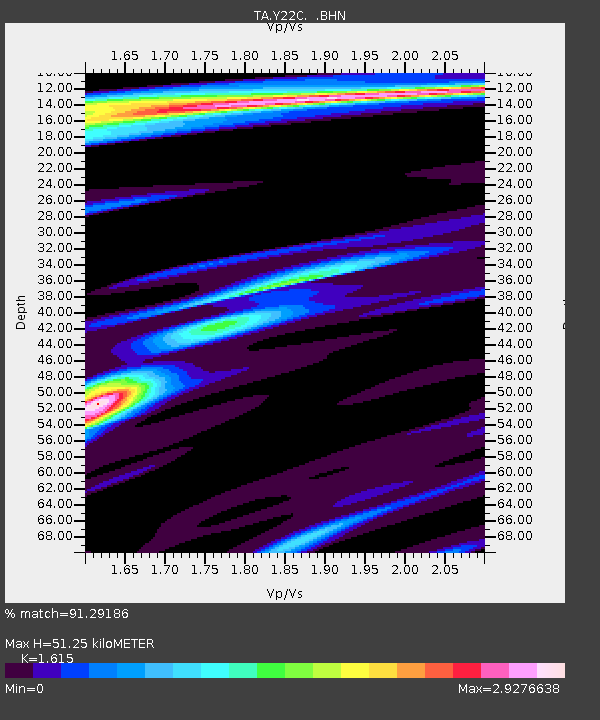
| Estimated Moho Depth: |
51.25 km |
| Estimated Crust Vp/Vs: |
1.62 |
| Assumed Crust Vp: |
6.502 km/s |
| Estimated Crust Vs: |
4.026 km/s |
| Estimated Crust Poisson's Ratio: |
0.19 |
|
| Radial Match: |
91.29186 % |
| Radial Bump: |
250 |
| Transverse Match: |
74.02797 % |
| Transverse Bump: |
400 |
| SOD ConfigId: |
2459 |
| Insert Time: |
2010-03-07 03:24:20.876 +0000 |
| GWidth: |
2.5 |
| Max Bumps: |
400 |
| Tol: |
0.001 |
|

Signal To Noise
| Channel | StoN | STA | LTA |
| TA:Y22C: :BHN:20041115T09:13:59.773989Z | 2.873499 | 2.1599715E-6 | 7.5168685E-7 |
| TA:Y22C: :BHE:20041115T09:13:59.773989Z | 3.6826694 | 2.9439311E-6 | 7.994014E-7 |
| TA:Y22C: :BHZ:20041115T09:13:59.773989Z | 21.455036 | 6.379607E-6 | 2.9734775E-7 |
| Arrivals |
| Ps | 5.2 SECOND |
| PpPs | 19 SECOND |
| PsPs/PpSs | 24 SECOND |


