You are here: Home > Network List > TA - USArray Transportable Network (new EarthScope stations) Stations List
> Station K01A Sixes, OR, USA > Earthquake Result Viewer
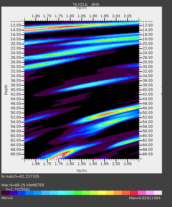
K01A Sixes, OR, USA - Earthquake Result Viewer
| Earthquake location: |
Volcano Islands, Japan Region |
| Earthquake latitude/longitude: |
22.0/142.7 |
| Earthquake time(UTC): |
2007/09/28 (271) 13:38:59 GMT |
| Earthquake Depth: |
276 km |
| Earthquake Magnitude: |
6.7 MB, 7.4 MW, 7.4 MW |
| Earthquake Catalog/Contributor: |
WHDF/NEIC |
|
| Network: |
TA USArray Transportable Network (new EarthScope stations) |
| Station: |
K01A Sixes, OR, USA |
| Lat/Lon: |
42.81 N/124.47 W |
| Elevation: |
175 m |
|
| Distance: |
77.4 deg |
| Az: |
48.857 deg |
| Baz: |
288.254 deg |
| Ray Param: |
0.04959454 |
| Estimated Moho Depth: |
69.25 km |
| Estimated Crust Vp/Vs: |
1.74 |
| Assumed Crust Vp: |
6.048 km/s |
| Estimated Crust Vs: |
3.471 km/s |
| Estimated Crust Poisson's Ratio: |
0.25 |
|
| Radial Match: |
92.237305 % |
| Radial Bump: |
400 |
| Transverse Match: |
88.53525 % |
| Transverse Bump: |
400 |
| SOD ConfigId: |
2564 |
| Insert Time: |
2010-03-07 03:24:29.657 +0000 |
| GWidth: |
2.5 |
| Max Bumps: |
400 |
| Tol: |
0.001 |
|

Signal To Noise
| Channel | StoN | STA | LTA |
| TA:K01A: :BHN:20070928T13:49:53.250012Z | 4.5831075 | 1.6876875E-6 | 3.6824085E-7 |
| TA:K01A: :BHE:20070928T13:49:53.250012Z | 11.13308 | 4.7465983E-6 | 4.2635088E-7 |
| TA:K01A: :BHZ:20070928T13:49:53.250012Z | 31.121166 | 1.7296186E-5 | 5.5576925E-7 |
| Arrivals |
| Ps | 8.7 SECOND |
| PpPs | 31 SECOND |
| PsPs/PpSs | 39 SECOND |


