
Station TA K01A - Sixes, OR, USA
Network: TA - USArray Transportable Network (new EarthScope stations)
Nearby stations (2 deg radius)
| Station | Name | (Lat, Lon) | Start / End | Elevation |
| K01A | Sixes, OR, USA | (42.81, -124.47) | 2005-12-20 / 2499-01-01 | 0.2 km |
| Crust2 Type: | S2,continental slope, margin, transition 2 km seds. |
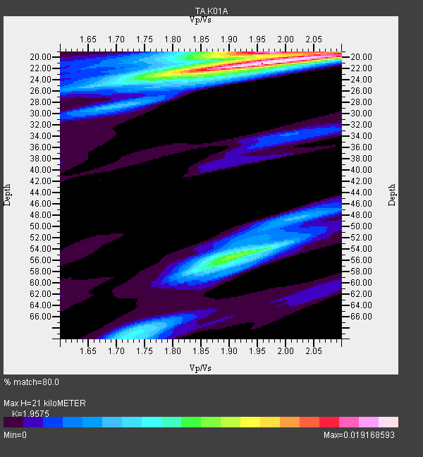
| Thickness Estimate: | 21 km |
| Thickness StdDev: | 9.7 km |
| Vp/Vs Estimate: | 1.96 |
| Vp/Vs StdDev: | 0.08 |
| Vs Estimate: | 3.09 km/s |
| Poisson's Ratio: | 0.32 |
| Peak Value: | 0.02 |
| Assumed Vp: | 6.048 km/s |
| Ps Weight: | 0.33333334 |
| PpPs Weight: | 0.33333334 |
| PsPs Weight: | 0.33333328 |
| Residual Complexity: | 0.612 |
| Nearby stations H: | +- |
| (2.0 deg) Vp/Vs: | +- |
8 with match > 90% ( 47.058823 %) and 17 with match > 80% ( 100.0 %) out of 17.
Download stack as xyz text file.
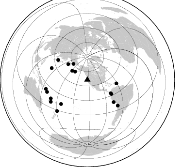
Azimuth Distribution of Events:
Prior Results for this Station
| Study | Thickness | Vp/Vs | Vp | Vs | Poissons Ratio | Extra |
| EARS | 21 km | 1.96 | 6.048 km/s | 3.09 km/s | 0.32 | |
| Crust2.0 | 24 km | 1.81 | 6.048 km/s | 3.34 km/s | 0.28 | S2,continental slope, margin, transition 2 km seds. |
| Global Maxima | 21 km | 1.96 | 6.048 km/s | 3.09 km/s | 0.32 | amp=0.019168593 |
| Local Maxima 1 | 19 km | 1.97 | 6.048 km/s | 3.07 km/s | 0.33 | amp=0.014075158 |
| Local Maxima 2 | 55 km | 1.91 | 6.048 km/s | 3.162 km/s | 0.31 | amp=0.010203986 |
| Local Maxima 3 | 19 km | 2.10 | 6.048 km/s | 2.883 km/s | 0.35 | amp=0.0062136124 |
| Local Maxima 4 | 70 km | 1.71 | 6.048 km/s | 3.542 km/s | 0.24 | amp=0.005810694 |
| Predicted Arrivals for vertical incidence (zero ray parameter) | |
| Ps | 3.32 SECOND |
| PpPs | 10.27 SECOND |
| PsPs/PpSs | 13.59 SECOND |
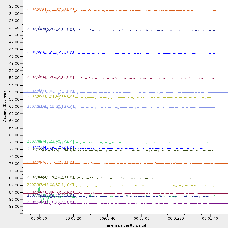
Events Processed for this Station
Download zip of receiver functions as SAC
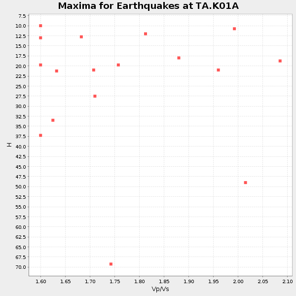
Plot maxima for each earthquake.
Events Used in the Stack
(17 events)| Radial Match | Distance | Baz | FERegion | Time | Lat/Lon | Depth | Magnitude |
| 95.551544 | 89.7 deg | 224.132 deg | Kermadec Islands Region | 2006/05/16 10:39:23 GMT | (-31.8, -179.3) | 152 km | 6.8 MB, 7.4 MW, 7.4 MW |
| 94.171455 | 81.9 deg | 130.314 deg | Northern Chile | 2007/11/14 15:40:50 GMT | (-22.2, -69.9) | 40 km | 6.7 MB, 7.4 MS, 7.7 MW, 7.4 ME |
| 93.067894 | 71.1 deg | 130.268 deg | Near Coast Of Peru | 2007/08/15 23:40:57 GMT | (-13.4, -76.6) | 39 km | 6.7 MB, 7.9 MS, 8.0 MW, 7.5 ME |
| 92.237305 | 77.4 deg | 288.254 deg | Volcano Islands, Japan Region | 2007/09/28 13:38:59 GMT | (22.0, 142.7) | 276 km | 6.7 MB, 7.4 MW, 7.4 MW |
| 91.94881 | 87.5 deg | 257.747 deg | Solomon Islands | 2007/04/01 21:11:33 GMT | (-7.3, 155.7) | 10 km | 6.3 MB |
| 91.67392 | 43.7 deg | 318.927 deg | Eastern Siberia, Russia | 2006/04/20 23:25:02 GMT | (60.9, 167.1) | 22 km | 6.8 MB, 7.6 MS, 7.6 MW, 7.3 MW |
| 90.86322 | 73.5 deg | 227.567 deg | Samoa Islands Region | 2006/09/28 06:22:09 GMT | (-16.6, -172.0) | 28 km | 6.5 MB, 6.6 MS, 6.9 MW, 6.7 MW |
| 90.656525 | 86.6 deg | 253.379 deg | Solomon Islands | 2007/08/16 08:39:27 GMT | (-9.8, 159.5) | 10 km | 6.1 MB, 6.7 MS, 6.4 MW |
| 89.57873 | 60.4 deg | 97.008 deg | Windward Islands | 2007/11/29 19:00:19 GMT | (15.0, -61.3) | 148 km | 6.9 MB, 7.4 MW, 7.4 MW |
| 88.77754 | 36.6 deg | 300.685 deg | Andreanof Islands, Aleutian Is. | 2007/08/15 20:22:11 GMT | (50.3, -177.5) | 9.0 km | 6.3 MB, 6.2 MS, 6.4 MW, 5.9 ML |
| 87.41869 | 84.3 deg | 243.119 deg | Vanuatu Islands | 2007/07/15 09:27:34 GMT | (-15.4, 168.6) | 8.0 km | 6.0 MB, 5.8 MS, 6.1 MW, 6.0 MW |
| 87.16401 | 87.6 deg | 239.052 deg | Vanuatu Islands | 2007/03/25 00:40:01 GMT | (-20.6, 169.4) | 34 km | 6.5 MB, 7.0 MS, 7.1 MW, 7.1 MW |
| 86.50523 | 55.7 deg | 119.816 deg | South Of Panama | 2007/03/18 02:11:05 GMT | (4.6, -78.5) | 8.0 km | 6.4 MB, 5.7 MS, 6.2 MW, 6.1 MW |
| 82.78977 | 57.3 deg | 120.54 deg | Near West Coast Of Colombia | 2007/09/10 01:49:14 GMT | (3.0, -78.0) | 31 km | 6.1 MB, 6.7 MS, 6.8 MW |
| 82.59508 | 30.5 deg | 303.795 deg | Fox Islands, Aleutian Islands | 2007/07/15 13:08:00 GMT | (52.5, -168.0) | 10 km | 5.8 MB, 5.9 MS, 6.1 MW, 6.0 MW |
| 82.553894 | 72.9 deg | 304.385 deg | Sea Of Japan | 2007/07/16 14:17:37 GMT | (36.8, 134.9) | 350 km | 6.2 MB, 6.8 MW, 6.8 MW |
| 82.28579 | 51.3 deg | 309.331 deg | Kamchatka Peninsula, Russia | 2007/05/30 20:22:12 GMT | (52.1, 157.3) | 116 km | 6.4 MB, 6.4 MW, 6.4 MW |
Losers
(0 events)| Radial Match | Distance | Baz | FERegion | Time | Lat/Lon | Depth | Magnitude | Reason |
