You are here: Home > Network List > TA - USArray Transportable Network (new EarthScope stations) Stations List
> Station K01A Sixes, OR, USA > Earthquake Result Viewer
K01A Sixes, OR, USA - Earthquake Result Viewer

| Earthquake location: |
Near West Coast Of Colombia |
| Earthquake latitude/longitude: |
3.0/-78.0 |
| Earthquake time(UTC): |
2007/09/10 (253) 01:49:14 GMT |
| Earthquake Depth: |
31 km |
| Earthquake Magnitude: |
6.1 MB, 6.7 MS, 6.8 MW |
| Earthquake Catalog/Contributor: |
WHDF/NEIC |
|
| Network: |
TA USArray Transportable Network (new EarthScope stations) |
| Station: |
K01A Sixes, OR, USA |
| Lat/Lon: |
42.81 N/124.47 W |
| Elevation: |
175 m |
|
| Distance: |
57.3 deg |
| Az: |
320.606 deg |
| Baz: |
120.54 deg |
| Ray Param: |
0.06355336 |
| Estimated Moho Depth: |
21.0 km |
| Estimated Crust Vp/Vs: |
1.71 |
| Assumed Crust Vp: |
6.048 km/s |
| Estimated Crust Vs: |
3.542 km/s |
| Estimated Crust Poisson's Ratio: |
0.24 |
|
| Radial Match: |
82.78977 % |
| Radial Bump: |
400 |
| Transverse Match: |
66.27975 % |
| Transverse Bump: |
400 |
| SOD ConfigId: |
2564 |
| Insert Time: |
2010-03-07 03:24:33.077 +0000 |
| GWidth: |
2.5 |
| Max Bumps: |
400 |
| Tol: |
0.001 |
|
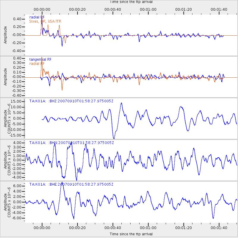
Signal To Noise
| Channel | StoN | STA | LTA |
| TA:K01A: :BHN:20070910T01:58:27.975005Z | 0.9660552 | 7.8673116E-7 | 8.143749E-7 |
| TA:K01A: :BHE:20070910T01:58:27.975005Z | 2.2136908 | 1.2247662E-6 | 5.532688E-7 |
| TA:K01A: :BHZ:20070910T01:58:27.975005Z | 2.978529 | 3.4149782E-6 | 1.1465319E-6 |
| Arrivals |
| Ps | 2.6 SECOND |
| PpPs | 9.0 SECOND |
| PsPs/PpSs | 12 SECOND |


