You are here: Home > Network List > TA - USArray Transportable Network (new EarthScope stations) Stations List
> Station K01A Sixes, OR, USA > Earthquake Result Viewer
K01A Sixes, OR, USA - Earthquake Result Viewer
| Earthquake location: |
Near Coast Of Peru |
| Earthquake latitude/longitude: |
-13.4/-76.6 |
| Earthquake time(UTC): |
2007/08/15 (227) 23:40:57 GMT |
| Earthquake Depth: |
39 km |
| Earthquake Magnitude: |
6.7 MB, 7.9 MS, 8.0 MW, 7.5 ME |
| Earthquake Catalog/Contributor: |
WHDF/NEIC |
|
| Network: |
TA USArray Transportable Network (new EarthScope stations) |
| Station: |
K01A Sixes, OR, USA |
| Lat/Lon: |
42.81 N/124.47 W |
| Elevation: |
175 m |
|
| Distance: |
71.1 deg |
| Az: |
324.761 deg |
| Baz: |
130.268 deg |
| Ray Param: |
0.054509852 |
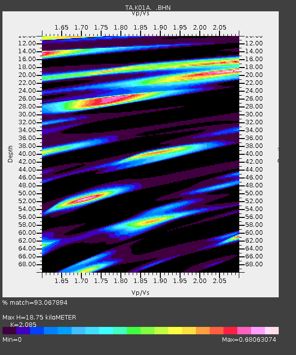
| Estimated Moho Depth: |
18.75 km |
| Estimated Crust Vp/Vs: |
2.09 |
| Assumed Crust Vp: |
6.048 km/s |
| Estimated Crust Vs: |
2.901 km/s |
| Estimated Crust Poisson's Ratio: |
0.35 |
|
| Radial Match: |
93.067894 % |
| Radial Bump: |
400 |
| Transverse Match: |
87.54537 % |
| Transverse Bump: |
400 |
| SOD ConfigId: |
2564 |
| Insert Time: |
2010-03-07 03:24:38.230 +0000 |
| GWidth: |
2.5 |
| Max Bumps: |
400 |
| Tol: |
0.001 |
|
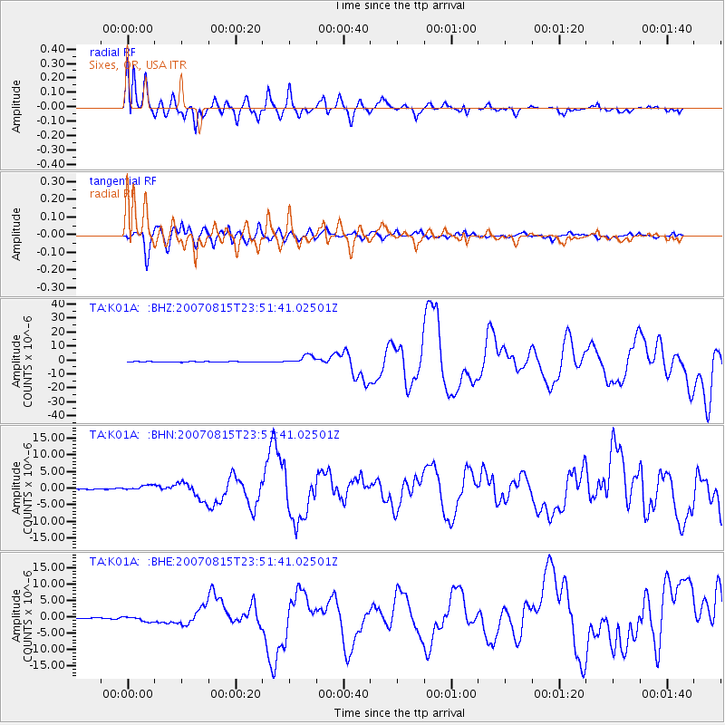
Signal To Noise
| Channel | StoN | STA | LTA |
| TA:K01A: :BHN:20070815T23:51:41.02501Z | 7.430759 | 8.246822E-7 | 1.1098223E-7 |
| TA:K01A: :BHE:20070815T23:51:41.02501Z | 4.1405435 | 8.048918E-7 | 1.9439278E-7 |
| TA:K01A: :BHZ:20070815T23:51:41.02501Z | 16.865328 | 3.1125103E-6 | 1.8455081E-7 |
| Arrivals |
| Ps | 3.5 SECOND |
| PpPs | 9.3 SECOND |
| PsPs/PpSs | 13 SECOND |


