You are here: Home > Network List > TA - USArray Transportable Network (new EarthScope stations) Stations List
> Station K01A Sixes, OR, USA > Earthquake Result Viewer
K01A Sixes, OR, USA - Earthquake Result Viewer

| Earthquake location: |
Vanuatu Islands |
| Earthquake latitude/longitude: |
-15.4/168.6 |
| Earthquake time(UTC): |
2007/07/15 (196) 09:27:34 GMT |
| Earthquake Depth: |
8.0 km |
| Earthquake Magnitude: |
6.0 MB, 5.8 MS, 6.1 MW, 6.0 MW |
| Earthquake Catalog/Contributor: |
WHDF/NEIC |
|
| Network: |
TA USArray Transportable Network (new EarthScope stations) |
| Station: |
K01A Sixes, OR, USA |
| Lat/Lon: |
42.81 N/124.47 W |
| Elevation: |
175 m |
|
| Distance: |
84.3 deg |
| Az: |
42.879 deg |
| Baz: |
243.119 deg |
| Ray Param: |
0.045597397 |
| Estimated Moho Depth: |
21.0 km |
| Estimated Crust Vp/Vs: |
1.96 |
| Assumed Crust Vp: |
6.048 km/s |
| Estimated Crust Vs: |
3.086 km/s |
| Estimated Crust Poisson's Ratio: |
0.32 |
|
| Radial Match: |
87.41869 % |
| Radial Bump: |
384 |
| Transverse Match: |
80.65165 % |
| Transverse Bump: |
400 |
| SOD ConfigId: |
2564 |
| Insert Time: |
2010-03-07 03:24:48.518 +0000 |
| GWidth: |
2.5 |
| Max Bumps: |
400 |
| Tol: |
0.001 |
|
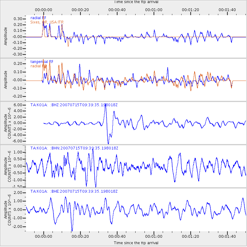
Signal To Noise
| Channel | StoN | STA | LTA |
| TA:K01A: :BHN:20070715T09:39:35.198018Z | 2.5700831 | 5.130061E-7 | 1.9960683E-7 |
| TA:K01A: :BHE:20070715T09:39:35.198018Z | 2.3203444 | 5.68647E-7 | 2.4507008E-7 |
| TA:K01A: :BHZ:20070715T09:39:35.198018Z | 7.7248964 | 2.4921833E-6 | 3.2261707E-7 |
| Arrivals |
| Ps | 3.4 SECOND |
| PpPs | 10 SECOND |
| PsPs/PpSs | 13 SECOND |


