You are here: Home > Network List > TA - USArray Transportable Network (new EarthScope stations) Stations List
> Station K01A Sixes, OR, USA > Earthquake Result Viewer
K01A Sixes, OR, USA - Earthquake Result Viewer
| Earthquake location: |
Kamchatka Peninsula, Russia |
| Earthquake latitude/longitude: |
52.1/157.3 |
| Earthquake time(UTC): |
2007/05/30 (150) 20:22:12 GMT |
| Earthquake Depth: |
116 km |
| Earthquake Magnitude: |
6.4 MB, 6.4 MW, 6.4 MW |
| Earthquake Catalog/Contributor: |
WHDF/NEIC |
|
| Network: |
TA USArray Transportable Network (new EarthScope stations) |
| Station: |
K01A Sixes, OR, USA |
| Lat/Lon: |
42.81 N/124.47 W |
| Elevation: |
175 m |
|
| Distance: |
51.3 deg |
| Az: |
67.448 deg |
| Baz: |
309.331 deg |
| Ray Param: |
0.06713919 |
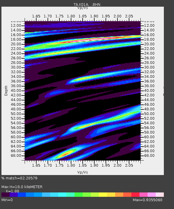
| Estimated Moho Depth: |
18.0 km |
| Estimated Crust Vp/Vs: |
1.88 |
| Assumed Crust Vp: |
6.048 km/s |
| Estimated Crust Vs: |
3.217 km/s |
| Estimated Crust Poisson's Ratio: |
0.30 |
|
| Radial Match: |
82.28579 % |
| Radial Bump: |
400 |
| Transverse Match: |
79.382904 % |
| Transverse Bump: |
400 |
| SOD ConfigId: |
2564 |
| Insert Time: |
2010-03-07 03:24:50.571 +0000 |
| GWidth: |
2.5 |
| Max Bumps: |
400 |
| Tol: |
0.001 |
|
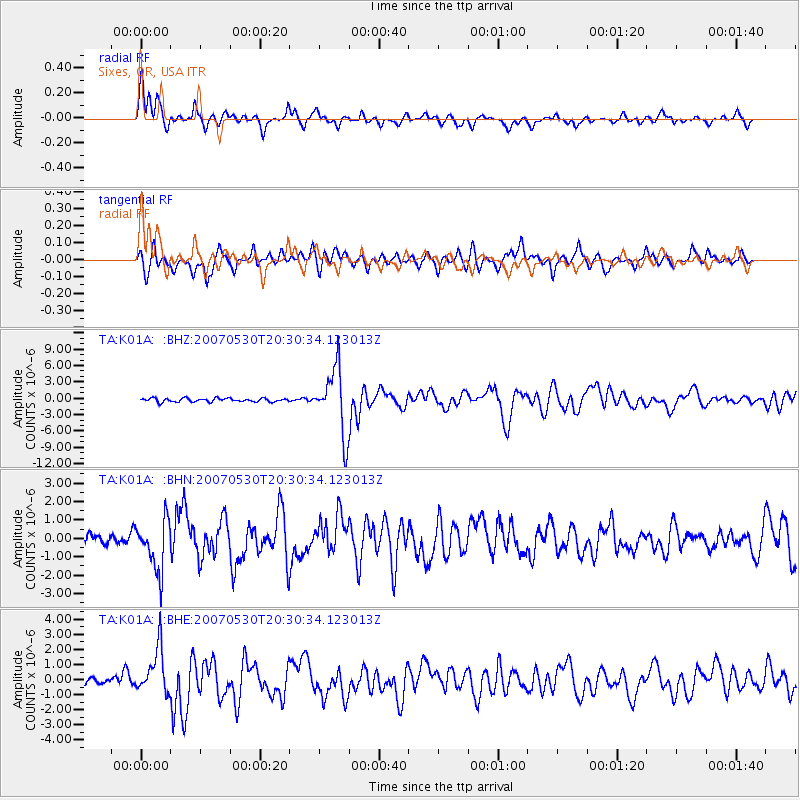
Signal To Noise
| Channel | StoN | STA | LTA |
| TA:K01A: :BHN:20070530T20:30:34.123013Z | 3.993382 | 1.3671931E-6 | 3.4236473E-7 |
| TA:K01A: :BHE:20070530T20:30:34.123013Z | 5.9563746 | 1.5031617E-6 | 2.5236184E-7 |
| TA:K01A: :BHZ:20070530T20:30:34.123013Z | 18.002775 | 5.934623E-6 | 3.2965045E-7 |
| Arrivals |
| Ps | 2.7 SECOND |
| PpPs | 8.2 SECOND |
| PsPs/PpSs | 11 SECOND |


