You are here: Home > Network List > TA - USArray Transportable Network (new EarthScope stations) Stations List
> Station K12A Draper Farm, Castleford, ID, USA > Earthquake Result Viewer
K12A Draper Farm, Castleford, ID, USA - Earthquake Result Viewer
| Earthquake location: |
South Of Fiji Islands |
| Earthquake latitude/longitude: |
-25.8/179.5 |
| Earthquake time(UTC): |
2007/10/16 (289) 21:05:43 GMT |
| Earthquake Depth: |
509 km |
| Earthquake Magnitude: |
6.2 MB, 6.6 MW, 6.5 MW |
| Earthquake Catalog/Contributor: |
WHDF/NEIC |
|
| Network: |
TA USArray Transportable Network (new EarthScope stations) |
| Station: |
K12A Draper Farm, Castleford, ID, USA |
| Lat/Lon: |
42.64 N/114.90 W |
| Elevation: |
1091 m |
|
| Distance: |
91.0 deg |
| Az: |
42.217 deg |
| Baz: |
235.187 deg |
| Ray Param: |
0.04138261 |
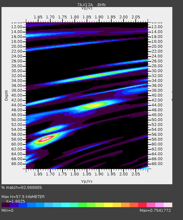
| Estimated Moho Depth: |
57.5 km |
| Estimated Crust Vp/Vs: |
1.68 |
| Assumed Crust Vp: |
6.291 km/s |
| Estimated Crust Vs: |
3.739 km/s |
| Estimated Crust Poisson's Ratio: |
0.23 |
|
| Radial Match: |
82.888885 % |
| Radial Bump: |
400 |
| Transverse Match: |
76.80316 % |
| Transverse Bump: |
400 |
| SOD ConfigId: |
2564 |
| Insert Time: |
2010-03-07 03:29:05.853 +0000 |
| GWidth: |
2.5 |
| Max Bumps: |
400 |
| Tol: |
0.001 |
|

Signal To Noise
| Channel | StoN | STA | LTA |
| TA:K12A: :BHN:20071016T21:17:21.100017Z | 4.7441306 | 5.304647E-7 | 1.1181494E-7 |
| TA:K12A: :BHE:20071016T21:17:21.100017Z | 5.52385 | 7.5533296E-7 | 1.3674031E-7 |
| TA:K12A: :BHZ:20071016T21:17:21.100017Z | 18.805614 | 3.0788221E-6 | 1.6371824E-7 |
| Arrivals |
| Ps | 6.4 SECOND |
| PpPs | 24 SECOND |
| PsPs/PpSs | 30 SECOND |


