
Station TA K12A - Draper Farm, Castleford, ID, USA
Network: TA - USArray Transportable Network (new EarthScope stations)
Nearby stations (2 deg radius)
| Station | Name | (Lat, Lon) | Start / End | Elevation |
| K12A | Draper Farm, Castleford, ID, USA | (42.64, -114.90) | 2006-12-11 / 2499-01-01 | 1.1 km |
| Crust2 Type: | M9,thick extended crust, 0.5 km seds. |
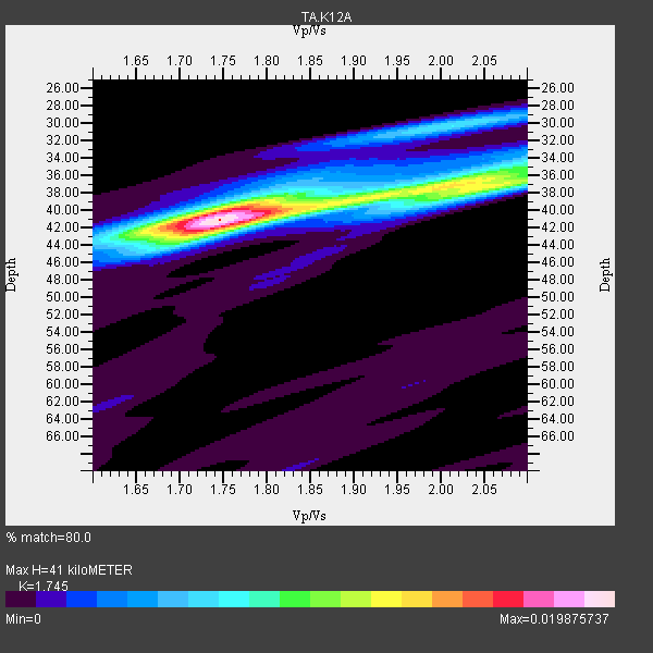
| Thickness Estimate: | 41 km |
| Thickness StdDev: | 1.2 km |
| Vp/Vs Estimate: | 1.75 |
| Vp/Vs StdDev: | 0.08 |
| Vs Estimate: | 3.605 km/s |
| Poisson's Ratio: | 0.26 |
| Peak Value: | 0.02 |
| Assumed Vp: | 6.291 km/s |
| Ps Weight: | 0.33333334 |
| PpPs Weight: | 0.33333334 |
| PsPs Weight: | 0.33333328 |
| Residual Complexity: | 0.553 |
| Nearby stations H: | +- |
| (2.0 deg) Vp/Vs: | +- |
24 with match > 90% ( 61.53846 %) and 39 with match > 80% ( 100.0 %) out of 39.
Download stack as xyz text file.
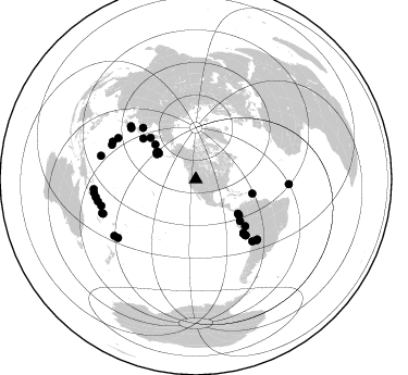
Azimuth Distribution of Events:
Prior Results for this Station
| Study | Thickness | Vp/Vs | Vp | Vs | Poissons Ratio | Extra |
| EARS | 41 km | 1.75 | 6.291 km/s | 3.605 km/s | 0.26 | |
| Crust2.0 | 40 km | 1.78 | 6.291 km/s | 3.539 km/s | 0.27 | M9,thick extended crust, 0.5 km seds. |
| Global Maxima | 41 km | 1.75 | 6.291 km/s | 3.605 km/s | 0.26 | amp=0.019875737 |
| Local Maxima 1 | 36 km | 2.03 | 6.291 km/s | 3.103 km/s | 0.34 | amp=0.010843277 |
| Local Maxima 2 | 43 km | 1.72 | 6.291 km/s | 3.668 km/s | 0.24 | amp=0.006995183 |
| Local Maxima 3 | 30 km | 2.01 | 6.291 km/s | 3.126 km/s | 0.34 | amp=0.0061183507 |
| Local Maxima 4 | 38 km | 2.04 | 6.291 km/s | 3.092 km/s | 0.34 | amp=0.005493086 |
| Predicted Arrivals for vertical incidence (zero ray parameter) | |
| Ps | 4.86 SECOND |
| PpPs | 17.89 SECOND |
| PsPs/PpSs | 22.74 SECOND |
Events Processed for this Station
Download zip of receiver functions as SAC
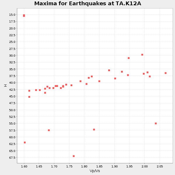
Plot maxima for each earthquake.
Events Used in the Stack
(39 events)| Radial Match | Distance | Baz | FERegion | Time | Lat/Lon | Depth | Magnitude |
| 98.54166 | 90.1 deg | 254.34 deg | Santa Cruz Islands | 2007/09/02 01:05:18 GMT | (-11.6, 165.8) | 35 km | 5.9 MB, 7.3 MS, 7.2 MW, 6.9 ME |
| 98.51015 | 76.7 deg | 137.687 deg | Northern Chile | 2007/11/14 15:40:50 GMT | (-22.2, -69.9) | 40 km | 6.7 MB, 7.4 MS, 7.7 MW, 7.4 ME |
| 98.30501 | 65.9 deg | 138.643 deg | Near Coast Of Peru | 2007/08/15 23:40:57 GMT | (-13.4, -76.6) | 39 km | 6.7 MB, 7.9 MS, 8.0 MW, 7.5 ME |
| 98.04896 | 94.2 deg | 262.479 deg | Solomon Islands | 2007/04/01 20:39:56 GMT | (-8.5, 157.0) | 10 km | 6.8 MB, 7.9 MS, 8.1 MW, 7.7 ME |
| 97.71116 | 61.3 deg | 307.679 deg | East Of Kuril Islands | 2007/01/13 04:23:21 GMT | (46.2, 154.5) | 10 km | 7.3 MB, 8.2 MS, 8.1 MW, 7.9 MW |
| 97.270294 | 78.8 deg | 134.383 deg | Jujuy Province, Argentina | 2007/07/21 15:34:52 GMT | (-22.2, -65.8) | 290 km | 5.8 MB, 6.4 MW, 6.3 MW |
| 96.667595 | 53.4 deg | 104.22 deg | Windward Islands | 2007/11/29 19:00:19 GMT | (15.0, -61.3) | 148 km | 6.9 MB, 7.4 MW, 7.4 MW |
| 96.53981 | 55.9 deg | 133.307 deg | Peru-Ecuador Border Region | 2007/11/16 03:13:00 GMT | (-2.3, -77.8) | 123 km | 6.3 MB, 6.8 MW, 6.7 MW |
| 96.3283 | 91.5 deg | 250.188 deg | Vanuatu Islands | 2007/08/01 17:08:51 GMT | (-15.6, 167.7) | 120 km | 6.2 MB, 7.2 MW, 7.2 MW |
| 95.40912 | 51.4 deg | 129.833 deg | Near West Coast Of Colombia | 2007/09/10 01:49:14 GMT | (3.0, -78.0) | 31 km | 6.1 MB, 6.7 MS, 6.8 MW |
| 95.36507 | 42.7 deg | 302.85 deg | Andreanof Islands, Aleutian Is. | 2007/08/15 20:22:11 GMT | (50.3, -177.5) | 9.0 km | 6.3 MB, 6.2 MS, 6.4 MW, 5.9 ML |
| 95.23073 | 89.4 deg | 233.049 deg | South Of Fiji Islands | 2007/12/09 07:28:20 GMT | (-26.0, -177.5) | 152 km | 7.0 MB, 7.8 MW, 7.7 MW |
| 94.80564 | 49.8 deg | 129.224 deg | South Of Panama | 2007/03/18 02:11:05 GMT | (4.6, -78.5) | 8.0 km | 6.4 MB, 5.7 MS, 6.2 MW, 6.1 MW |
| 93.90148 | 84.0 deg | 294.337 deg | Volcano Islands, Japan Region | 2007/09/28 13:38:59 GMT | (22.0, 142.7) | 276 km | 6.7 MB, 7.4 MW, 7.4 MW |
| 93.7556 | 43.6 deg | 304.791 deg | Andreanof Islands, Aleutian Is. | 2007/12/19 09:30:27 GMT | (51.4, -179.5) | 29 km | 6.4 MB, 7.1 MS, 7.1 MW, 7.0 MW |
| 92.72668 | 93.4 deg | 259.854 deg | Solomon Islands | 2007/08/16 08:39:27 GMT | (-9.8, 159.5) | 10 km | 6.1 MB, 6.7 MS, 6.4 MW |
| 92.49434 | 76.0 deg | 308.296 deg | Near West Coast Of Honshu, Japan | 2007/07/16 01:13:22 GMT | (37.5, 138.4) | 12 km | 6.5 MB, 6.4 MS, 6.6 MW, 6.5 MW |
| 92.448524 | 89.8 deg | 283.958 deg | South Of Mariana Islands | 2007/09/30 02:08:30 GMT | (10.5, 145.7) | 14 km | 6.4 MB, 7.1 MS, 6.9 MW, 6.9 MW |
| 92.30456 | 56.7 deg | 312.541 deg | Kamchatka Peninsula, Russia | 2007/05/30 20:22:12 GMT | (52.1, 157.3) | 116 km | 6.4 MB, 6.4 MW, 6.4 MW |
| 92.07105 | 41.5 deg | 304.772 deg | Andreanof Islands, Aleutian Is. | 2007/07/13 21:54:43 GMT | (51.8, -176.3) | 35 km | 5.7 MB, 5.6 MS, 6.0 MW, 5.9 MW |
| 91.87524 | 67.9 deg | 314.143 deg | Sakhalin, Russia | 2007/08/02 02:37:42 GMT | (47.1, 141.8) | 5.0 km | 6.2 MS, 5.3 MB, 6.2 MW, 6.2 MW |
| 91.505516 | 66.9 deg | 138.694 deg | Near Coast Of Peru | 2007/08/16 05:16:56 GMT | (-14.3, -76.1) | 23 km | 5.8 MB, 6.1 MS, 6.3 MW, 6.2 ML |
| 90.64105 | 90.7 deg | 249.725 deg | Vanuatu Islands | 2007/07/15 09:27:34 GMT | (-15.4, 168.6) | 8.0 km | 6.0 MB, 5.8 MS, 6.1 MW, 6.0 MW |
| 90.4726 | 62.4 deg | 133.432 deg | Peru-Brazil Border Region | 2007/07/12 05:23:49 GMT | (-7.9, -74.4) | 152 km | 5.9 MB, 6.1 MW, 6.0 MW |
| 89.94699 | 77.2 deg | 309.199 deg | Near West Coast Of Honshu, Japan | 2007/03/25 00:41:57 GMT | (37.3, 136.6) | 8.0 km | 6.1 MB, 6.8 MS, 6.7 MW, 6.6 MW |
| 88.75823 | 43.3 deg | 304.659 deg | Andreanof Islands, Aleutian Is. | 2007/12/21 07:24:34 GMT | (51.4, -179.0) | 30 km | 6.1 MB, 6.2 MW, 6.3 ML |
| 87.66943 | 66.1 deg | 138.786 deg | Near Coast Of Peru | 2007/08/19 01:22:40 GMT | (-13.6, -76.6) | 26 km | 5.9 MB, 5.4 MS, 5.8 MW, 5.5 ML |
| 86.99575 | 92.2 deg | 257.244 deg | Solomon Islands | 2007/11/27 11:49:58 GMT | (-10.9, 162.1) | 16 km | 5.9 MB, 6.7 MS, 6.6 MW, 6.4 MW |
| 86.52262 | 42.9 deg | 305.764 deg | Andreanof Islands, Aleutian Is. | 2008/03/22 21:24:11 GMT | (52.2, -178.7) | 132 km | 5.8 MB, 6.2 MW, 6.1 MW |
| 86.49217 | 80.9 deg | 297.983 deg | Bonin Islands, Japan Region | 2008/02/27 06:54:20 GMT | (26.8, 142.4) | 15 km | 5.8 MB, 6.1 MS, 6.2 MW, 6.2 MW |
| 86.27071 | 49.2 deg | 310.467 deg | Komandorskiye Ostrova Region | 2007/07/29 04:54:36 GMT | (53.6, 169.7) | 26 km | 6.0 MB, 5.5 MS, 5.9 MW, 5.8 MW |
| 86.041336 | 83.4 deg | 292.28 deg | Mariana Islands | 2007/01/30 21:37:45 GMT | (21.0, 144.7) | 30 km | 6.3 MB, 6.5 MS, 6.6 MW, 6.5 MW |
| 85.30134 | 68.7 deg | 138.343 deg | Near Coast Of Peru | 2007/06/28 08:44:48 GMT | (-15.7, -74.9) | 27 km | 5.5 MB, 5.3 MS, 5.8 MW, 5.8 MW |
| 82.888885 | 91.0 deg | 235.187 deg | South Of Fiji Islands | 2007/10/16 21:05:43 GMT | (-25.8, 179.5) | 509 km | 6.2 MB, 6.6 MW, 6.5 MW |
| 82.43616 | 68.8 deg | 138.423 deg | Near Coast Of Peru | 2007/06/29 02:02:17 GMT | (-15.8, -74.9) | 16 km | 5.7 MW, 5.0 MS, 5.3 MB, 5.6 MW |
| 82.31559 | 94.2 deg | 264.437 deg | Solomon Islands | 2007/12/19 11:34:56 GMT | (-7.0, 155.8) | 46 km | 5.7 MB, 5.9 MS |
| 80.59161 | 78.9 deg | 135.09 deg | Jujuy Province, Argentina | 2007/11/18 05:40:12 GMT | (-22.6, -66.3) | 246 km | 5.7 MB, 6.0 MW, 6.0 MW |
| 80.30874 | 85.6 deg | 93.105 deg | Central Mid-Atlantic Ridge | 2007/07/03 08:26:00 GMT | (0.7, -30.3) | 10 km | 5.8 MB, 5.9 MS, 6.3 MW, 6.1 MW |
| 80.0007 | 43.3 deg | 304.504 deg | Andreanof Islands, Aleutian Is. | 2007/12/21 07:23:35 GMT | (51.2, -179.0) | 30 km | 5.7 MB, 5.5 ML |
Losers
(0 events)| Radial Match | Distance | Baz | FERegion | Time | Lat/Lon | Depth | Magnitude | Reason |
