You are here: Home > Network List > TA - USArray Transportable Network (new EarthScope stations) Stations List
> Station K12A Draper Farm, Castleford, ID, USA > Earthquake Result Viewer
K12A Draper Farm, Castleford, ID, USA - Earthquake Result Viewer
| Earthquake location: |
Vanuatu Islands |
| Earthquake latitude/longitude: |
-15.6/167.7 |
| Earthquake time(UTC): |
2007/08/01 (213) 17:08:51 GMT |
| Earthquake Depth: |
120 km |
| Earthquake Magnitude: |
6.2 MB, 7.2 MW, 7.2 MW |
| Earthquake Catalog/Contributor: |
WHDF/NEIC |
|
| Network: |
TA USArray Transportable Network (new EarthScope stations) |
| Station: |
K12A Draper Farm, Castleford, ID, USA |
| Lat/Lon: |
42.64 N/114.90 W |
| Elevation: |
1091 m |
|
| Distance: |
91.5 deg |
| Az: |
46.091 deg |
| Baz: |
250.188 deg |
| Ray Param: |
0.041555848 |
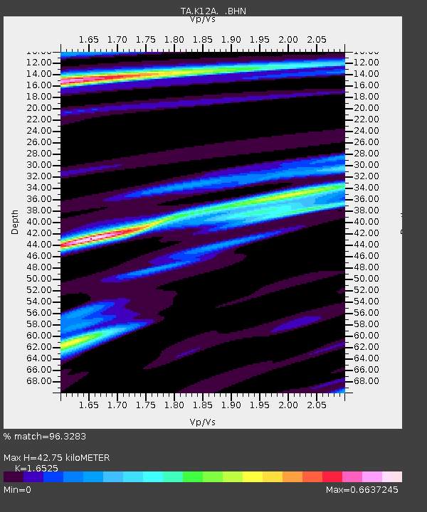
| Estimated Moho Depth: |
42.75 km |
| Estimated Crust Vp/Vs: |
1.65 |
| Assumed Crust Vp: |
6.291 km/s |
| Estimated Crust Vs: |
3.807 km/s |
| Estimated Crust Poisson's Ratio: |
0.21 |
|
| Radial Match: |
96.3283 % |
| Radial Bump: |
359 |
| Transverse Match: |
72.003365 % |
| Transverse Bump: |
400 |
| SOD ConfigId: |
2564 |
| Insert Time: |
2010-03-07 03:29:24.976 +0000 |
| GWidth: |
2.5 |
| Max Bumps: |
400 |
| Tol: |
0.001 |
|

Signal To Noise
| Channel | StoN | STA | LTA |
| TA:K12A: :BHN:20070801T17:21:12.873022Z | 0.9672797 | 5.8417516E-8 | 6.039361E-8 |
| TA:K12A: :BHE:20070801T17:21:12.873022Z | 2.2102063 | 1.4545819E-7 | 6.5812046E-8 |
| TA:K12A: :BHZ:20070801T17:21:12.873022Z | 5.972701 | 5.158099E-7 | 8.636125E-8 |
| Arrivals |
| Ps | 4.5 SECOND |
| PpPs | 18 SECOND |
| PsPs/PpSs | 22 SECOND |


