You are here: Home > Network List > TA - USArray Transportable Network (new EarthScope stations) Stations List
> Station K12A Draper Farm, Castleford, ID, USA > Earthquake Result Viewer
K12A Draper Farm, Castleford, ID, USA - Earthquake Result Viewer
| Earthquake location: |
Near West Coast Of Honshu, Japan |
| Earthquake latitude/longitude: |
37.5/138.4 |
| Earthquake time(UTC): |
2007/07/16 (197) 01:13:22 GMT |
| Earthquake Depth: |
12 km |
| Earthquake Magnitude: |
6.5 MB, 6.4 MS, 6.6 MW, 6.5 MW |
| Earthquake Catalog/Contributor: |
WHDF/NEIC |
|
| Network: |
TA USArray Transportable Network (new EarthScope stations) |
| Station: |
K12A Draper Farm, Castleford, ID, USA |
| Lat/Lon: |
42.64 N/114.90 W |
| Elevation: |
1091 m |
|
| Distance: |
76.0 deg |
| Az: |
46.763 deg |
| Baz: |
308.296 deg |
| Ray Param: |
0.051262014 |
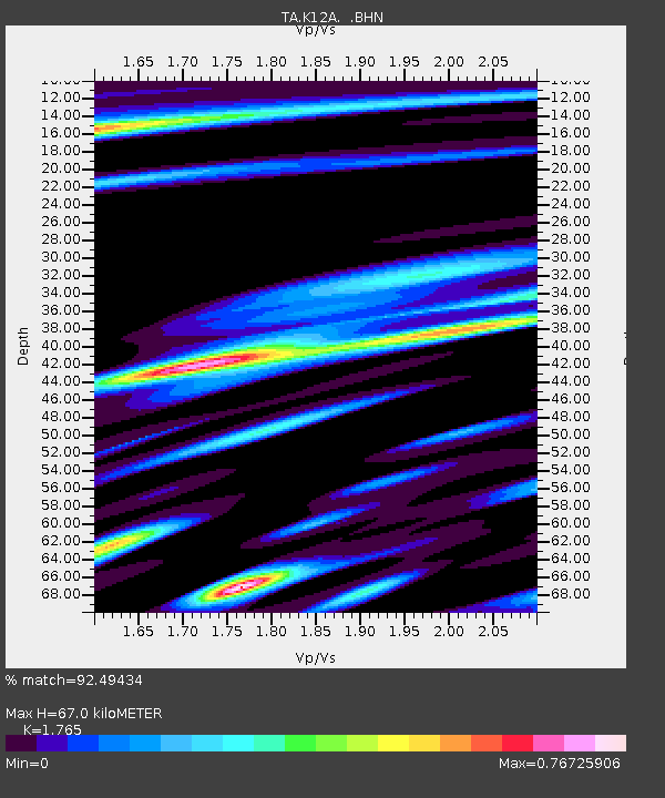
| Estimated Moho Depth: |
67.0 km |
| Estimated Crust Vp/Vs: |
1.76 |
| Assumed Crust Vp: |
6.291 km/s |
| Estimated Crust Vs: |
3.564 km/s |
| Estimated Crust Poisson's Ratio: |
0.26 |
|
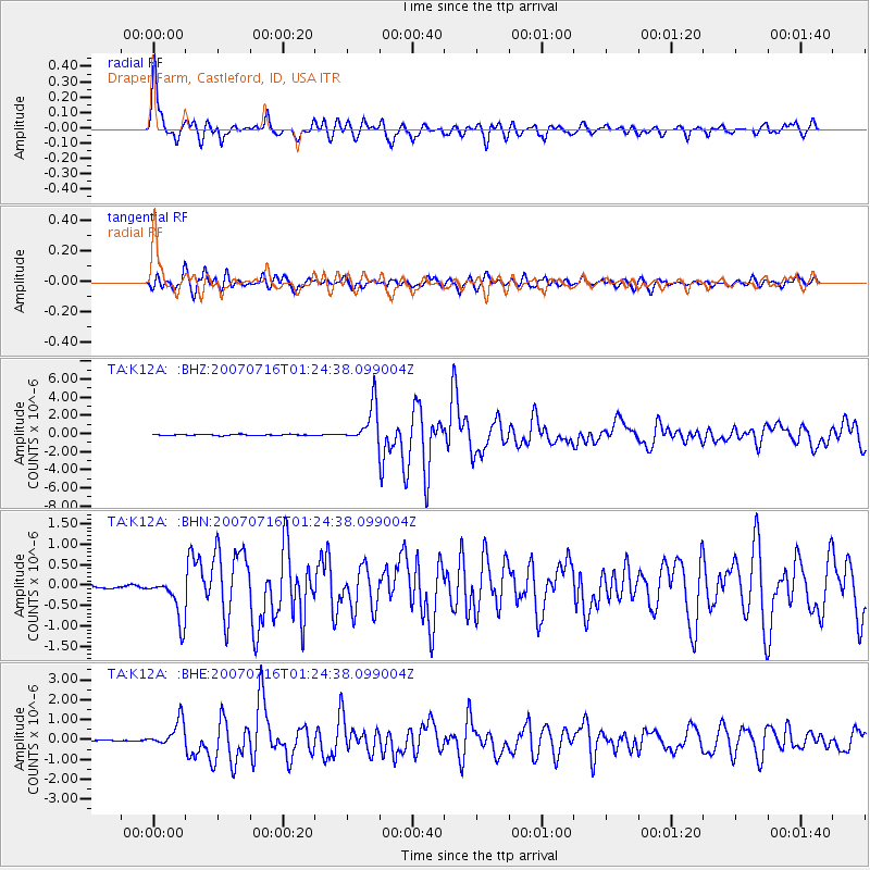
| Radial Match: |
92.49434 % |
| Radial Bump: |
400 |
| Transverse Match: |
85.023766 % |
| Transverse Bump: |
400 |
| SOD ConfigId: |
2564 |
| Insert Time: |
2010-03-07 03:29:31.156 +0000 |
| GWidth: |
2.5 |
| Max Bumps: |
400 |
| Tol: |
0.001 |
|
Signal To Noise
| Channel | StoN | STA | LTA |
| TA:K12A: :BHN:20070716T01:24:38.099004Z | 11.232961 | 5.2720964E-7 | 4.6934165E-8 |
| TA:K12A: :BHE:20070716T01:24:38.099004Z | 19.882437 | 6.5778886E-7 | 3.3083914E-8 |
| TA:K12A: :BHZ:20070716T01:24:38.099004Z | 36.751976 | 2.0979878E-6 | 5.708504E-8 |
| Arrivals |
| Ps | 8.4 SECOND |
| PpPs | 29 SECOND |
| PsPs/PpSs | 37 SECOND |


