You are here: Home > Network List > TA - USArray Transportable Network (new EarthScope stations) Stations List
> Station K12A Draper Farm, Castleford, ID, USA > Earthquake Result Viewer
K12A Draper Farm, Castleford, ID, USA - Earthquake Result Viewer
| Earthquake location: |
Peru-Brazil Border Region |
| Earthquake latitude/longitude: |
-7.9/-74.4 |
| Earthquake time(UTC): |
2007/07/12 (193) 05:23:49 GMT |
| Earthquake Depth: |
152 km |
| Earthquake Magnitude: |
5.9 MB, 6.1 MW, 6.0 MW |
| Earthquake Catalog/Contributor: |
WHDF/NEIC |
|
| Network: |
TA USArray Transportable Network (new EarthScope stations) |
| Station: |
K12A Draper Farm, Castleford, ID, USA |
| Lat/Lon: |
42.64 N/114.90 W |
| Elevation: |
1091 m |
|
| Distance: |
62.4 deg |
| Az: |
327.249 deg |
| Baz: |
133.432 deg |
| Ray Param: |
0.059794046 |
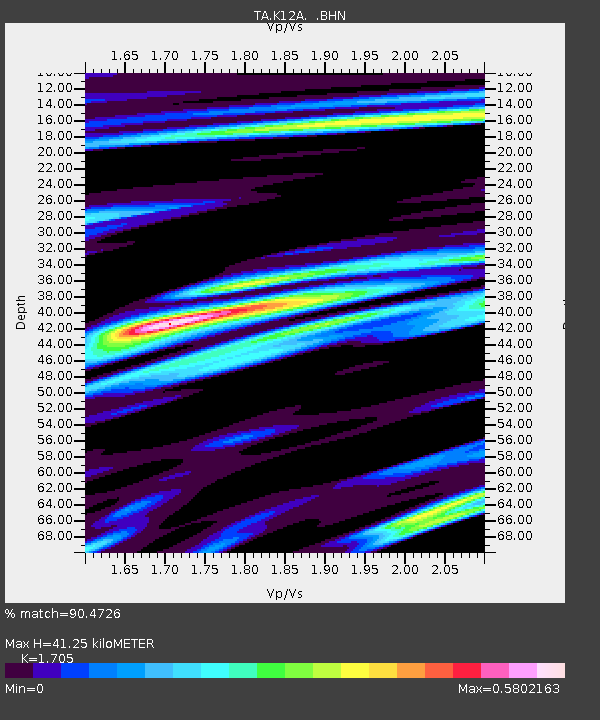
| Estimated Moho Depth: |
41.25 km |
| Estimated Crust Vp/Vs: |
1.71 |
| Assumed Crust Vp: |
6.291 km/s |
| Estimated Crust Vs: |
3.69 km/s |
| Estimated Crust Poisson's Ratio: |
0.24 |
|
| Radial Match: |
90.4726 % |
| Radial Bump: |
400 |
| Transverse Match: |
77.87735 % |
| Transverse Bump: |
400 |
| SOD ConfigId: |
2564 |
| Insert Time: |
2010-03-07 03:29:37.080 +0000 |
| GWidth: |
2.5 |
| Max Bumps: |
400 |
| Tol: |
0.001 |
|

Signal To Noise
| Channel | StoN | STA | LTA |
| TA:K12A: :BHN:20070712T05:33:25.35001Z | 4.5805154 | 2.3974903E-7 | 5.2341054E-8 |
| TA:K12A: :BHE:20070712T05:33:25.35001Z | 12.050504 | 3.138378E-7 | 2.604354E-8 |
| TA:K12A: :BHZ:20070712T05:33:25.35001Z | 11.561072 | 8.8395456E-7 | 7.645957E-8 |
| Arrivals |
| Ps | 4.8 SECOND |
| PpPs | 17 SECOND |
| PsPs/PpSs | 22 SECOND |


