You are here: Home > Network List > TA - USArray Transportable Network (new EarthScope stations) Stations List
> Station K12A Draper Farm, Castleford, ID, USA > Earthquake Result Viewer
K12A Draper Farm, Castleford, ID, USA - Earthquake Result Viewer
| Earthquake location: |
Central Mid-Atlantic Ridge |
| Earthquake latitude/longitude: |
0.7/-30.3 |
| Earthquake time(UTC): |
2007/07/03 (184) 08:26:00 GMT |
| Earthquake Depth: |
10 km |
| Earthquake Magnitude: |
5.8 MB, 5.9 MS, 6.3 MW, 6.1 MW |
| Earthquake Catalog/Contributor: |
WHDF/NEIC |
|
| Network: |
TA USArray Transportable Network (new EarthScope stations) |
| Station: |
K12A Draper Farm, Castleford, ID, USA |
| Lat/Lon: |
42.64 N/114.90 W |
| Elevation: |
1091 m |
|
| Distance: |
85.6 deg |
| Az: |
312.531 deg |
| Baz: |
93.105 deg |
| Ray Param: |
0.044676576 |
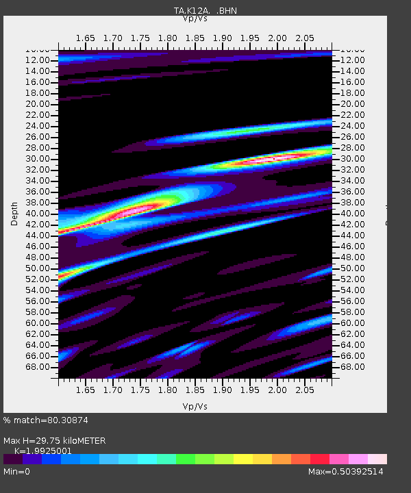
| Estimated Moho Depth: |
29.75 km |
| Estimated Crust Vp/Vs: |
1.99 |
| Assumed Crust Vp: |
6.291 km/s |
| Estimated Crust Vs: |
3.157 km/s |
| Estimated Crust Poisson's Ratio: |
0.33 |
|
| Radial Match: |
80.30874 % |
| Radial Bump: |
400 |
| Transverse Match: |
73.913025 % |
| Transverse Bump: |
400 |
| SOD ConfigId: |
2564 |
| Insert Time: |
2010-03-07 03:29:39.808 +0000 |
| GWidth: |
2.5 |
| Max Bumps: |
400 |
| Tol: |
0.001 |
|

Signal To Noise
| Channel | StoN | STA | LTA |
| TA:K12A: :BHN:20070703T08:38:07.599001Z | 0.8915193 | 6.919465E-8 | 7.76143E-8 |
| TA:K12A: :BHE:20070703T08:38:07.599001Z | 1.8887258 | 1.510191E-7 | 7.995819E-8 |
| TA:K12A: :BHZ:20070703T08:38:07.599001Z | 3.717571 | 3.1404397E-7 | 8.447559E-8 |
| Arrivals |
| Ps | 4.8 SECOND |
| PpPs | 14 SECOND |
| PsPs/PpSs | 19 SECOND |


