You are here: Home > Network List > TA - USArray Transportable Network (new EarthScope stations) Stations List
> Station K12A Draper Farm, Castleford, ID, USA > Earthquake Result Viewer
K12A Draper Farm, Castleford, ID, USA - Earthquake Result Viewer
| Earthquake location: |
Near Coast Of Peru |
| Earthquake latitude/longitude: |
-15.8/-74.9 |
| Earthquake time(UTC): |
2007/06/29 (180) 02:02:17 GMT |
| Earthquake Depth: |
16 km |
| Earthquake Magnitude: |
5.7 MW, 5.0 MS, 5.3 MB, 5.6 MW |
| Earthquake Catalog/Contributor: |
WHDF/NEIC |
|
| Network: |
TA USArray Transportable Network (new EarthScope stations) |
| Station: |
K12A Draper Farm, Castleford, ID, USA |
| Lat/Lon: |
42.64 N/114.90 W |
| Elevation: |
1091 m |
|
| Distance: |
68.8 deg |
| Az: |
329.428 deg |
| Baz: |
138.423 deg |
| Ray Param: |
0.0560764 |
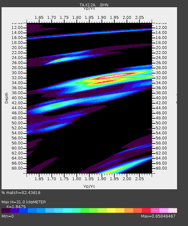
| Estimated Moho Depth: |
31.0 km |
| Estimated Crust Vp/Vs: |
1.95 |
| Assumed Crust Vp: |
6.291 km/s |
| Estimated Crust Vs: |
3.23 km/s |
| Estimated Crust Poisson's Ratio: |
0.32 |
|
| Radial Match: |
82.43616 % |
| Radial Bump: |
400 |
| Transverse Match: |
64.18576 % |
| Transverse Bump: |
400 |
| SOD ConfigId: |
2564 |
| Insert Time: |
2010-03-07 03:29:42.563 +0000 |
| GWidth: |
2.5 |
| Max Bumps: |
400 |
| Tol: |
0.001 |
|

Signal To Noise
| Channel | StoN | STA | LTA |
| TA:K12A: :BHN:20070629T02:12:49.225022Z | 1.2269707 | 5.46566E-8 | 4.454597E-8 |
| TA:K12A: :BHE:20070629T02:12:49.225022Z | 1.188042 | 5.6349222E-8 | 4.7430326E-8 |
| TA:K12A: :BHZ:20070629T02:12:49.225022Z | 3.740103 | 2.4805794E-7 | 6.632383E-8 |
| Arrivals |
| Ps | 4.8 SECOND |
| PpPs | 14 SECOND |
| PsPs/PpSs | 19 SECOND |


