You are here: Home > Network List > TA - USArray Transportable Network (new EarthScope stations) Stations List
> Station L22K Petersville, AK, USA > Earthquake Result Viewer
L22K Petersville, AK, USA - Earthquake Result Viewer
| Earthquake location: |
Fiji Islands Region |
| Earthquake latitude/longitude: |
-14.8/-177.3 |
| Earthquake time(UTC): |
2019/08/22 (234) 19:27:12 GMT |
| Earthquake Depth: |
10 km |
| Earthquake Magnitude: |
5.8 Mww |
| Earthquake Catalog/Contributor: |
NEIC PDE/us |
|
| Network: |
TA USArray Transportable Network (new EarthScope stations) |
| Station: |
L22K Petersville, AK, USA |
| Lat/Lon: |
62.53 N/150.77 W |
| Elevation: |
817 m |
|
| Distance: |
79.8 deg |
| Az: |
12.147 deg |
| Baz: |
206.031 deg |
| Ray Param: |
0.04869422 |
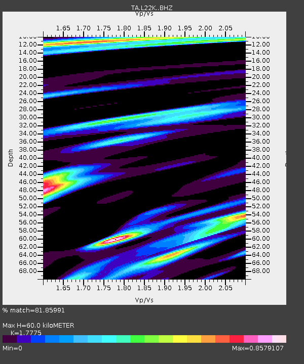
| Estimated Moho Depth: |
60.0 km |
| Estimated Crust Vp/Vs: |
1.78 |
| Assumed Crust Vp: |
6.438 km/s |
| Estimated Crust Vs: |
3.622 km/s |
| Estimated Crust Poisson's Ratio: |
0.27 |
|
| Radial Match: |
81.85991 % |
| Radial Bump: |
400 |
| Transverse Match: |
69.321106 % |
| Transverse Bump: |
400 |
| SOD ConfigId: |
19053131 |
| Insert Time: |
2019-09-05 19:36:47.992 +0000 |
| GWidth: |
2.5 |
| Max Bumps: |
400 |
| Tol: |
0.001 |
|

Signal To Noise
| Channel | StoN | STA | LTA |
| TA:L22K: :BHZ:20190822T19:38:49.300003Z | 3.8275247 | 2.9193316E-7 | 7.627205E-8 |
| TA:L22K: :BHN:20190822T19:38:49.300003Z | 0.79085636 | 9.447711E-8 | 1.1946177E-7 |
| TA:L22K: :BHE:20190822T19:38:49.300003Z | 1.0588946 | 1.3145264E-7 | 1.2414138E-7 |
| Arrivals |
| Ps | 7.5 SECOND |
| PpPs | 25 SECOND |
| PsPs/PpSs | 33 SECOND |


