You are here: Home > Network List > TA - USArray Transportable Network (new EarthScope stations) Stations List
> Station J05A Fort Rock, OR, USA > Earthquake Result Viewer
J05A Fort Rock, OR, USA - Earthquake Result Viewer

| Earthquake location: |
Komandorskiye Ostrova Region |
| Earthquake latitude/longitude: |
53.6/169.7 |
| Earthquake time(UTC): |
2007/07/29 (210) 04:54:36 GMT |
| Earthquake Depth: |
26 km |
| Earthquake Magnitude: |
6.0 MB, 5.5 MS, 5.9 MW, 5.8 MW |
| Earthquake Catalog/Contributor: |
WHDF/NEIC |
|
| Network: |
TA USArray Transportable Network (new EarthScope stations) |
| Station: |
J05A Fort Rock, OR, USA |
| Lat/Lon: |
43.28 N/121.24 W |
| Elevation: |
1540 m |
|
| Distance: |
45.2 deg |
| Az: |
73.88 deg |
| Baz: |
308.436 deg |
| Ray Param: |
0.07136984 |
| Estimated Moho Depth: |
31.75 km |
| Estimated Crust Vp/Vs: |
1.96 |
| Assumed Crust Vp: |
6.597 km/s |
| Estimated Crust Vs: |
3.366 km/s |
| Estimated Crust Poisson's Ratio: |
0.32 |
|
| Radial Match: |
82.53022 % |
| Radial Bump: |
400 |
| Transverse Match: |
73.38962 % |
| Transverse Bump: |
400 |
| SOD ConfigId: |
2564 |
| Insert Time: |
2010-03-07 03:33:37.393 +0000 |
| GWidth: |
2.5 |
| Max Bumps: |
400 |
| Tol: |
0.001 |
|
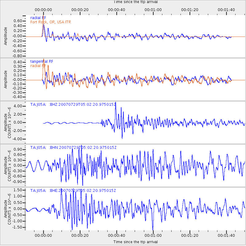
Signal To Noise
| Channel | StoN | STA | LTA |
| TA:J05A: :BHN:20070729T05:02:20.975015Z | 1.6769277 | 1.9642899E-7 | 1.1713623E-7 |
| TA:J05A: :BHE:20070729T05:02:20.975015Z | 1.4222846 | 1.4633123E-7 | 1.0288463E-7 |
| TA:J05A: :BHZ:20070729T05:02:20.975015Z | 3.921253 | 4.0277885E-7 | 1.02716875E-7 |
| Arrivals |
| Ps | 4.9 SECOND |
| PpPs | 13 SECOND |
| PsPs/PpSs | 18 SECOND |


