
Station TA J05A - Fort Rock, OR, USA
Network: TA - USArray Transportable Network (new EarthScope stations)
Nearby stations (2 deg radius)
| Station | Name | (Lat, Lon) | Start / End | Elevation |
| J05A | Fort Rock, OR, USA | (43.28, -121.24) | 2006-07-17 / 2499-01-01 | 1.5 km |
| Crust2 Type: | L3,continental arc, Southern Andes, 0.2 km seds. |
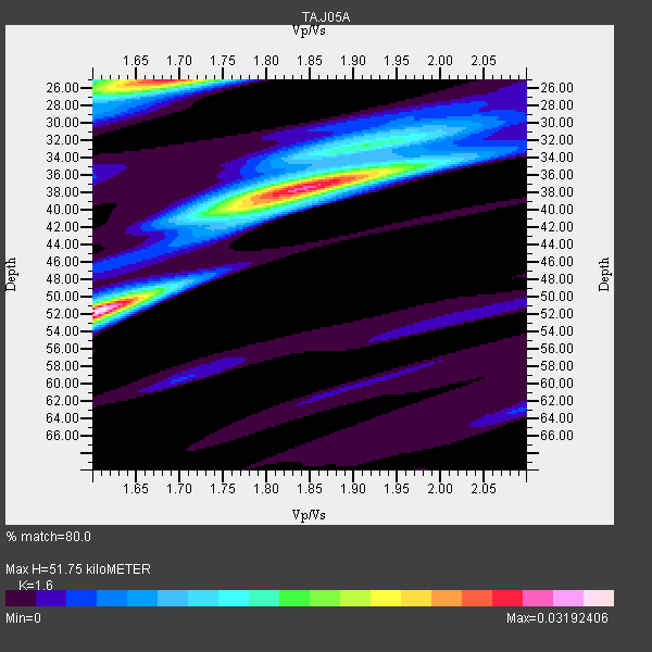
| Thickness Estimate: | 52 km |
| Thickness StdDev: | 11 km |
| Vp/Vs Estimate: | 1.60 |
| Vp/Vs StdDev: | 0.10 |
| Vs Estimate: | 4.123 km/s |
| Poisson's Ratio: | 0.18 |
| Peak Value: | 0.03 |
| Assumed Vp: | 6.597 km/s |
| Ps Weight: | 0.33333334 |
| PpPs Weight: | 0.33333334 |
| PsPs Weight: | 0.33333328 |
| Residual Complexity: | 0.871 |
| Nearby stations H: | +- |
| (2.0 deg) Vp/Vs: | +- |
10 with match > 90% ( 38.46154 %) and 26 with match > 80% ( 100.0 %) out of 26.
Download stack as xyz text file.
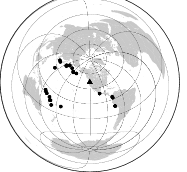
Azimuth Distribution of Events:
Prior Results for this Station
| Study | Thickness | Vp/Vs | Vp | Vs | Poissons Ratio | Extra |
| EARS | 52 km | 1.60 | 6.597 km/s | 4.123 km/s | 0.18 | |
| Crust2.0 | 40 km | 1.77 | 6.597 km/s | 3.723 km/s | 0.27 | L3,continental arc, Southern Andes, 0.2 km seds. |
| Global Maxima | 52 km | 1.60 | 6.597 km/s | 4.123 km/s | 0.18 | amp=0.03192406 |
| Local Maxima 1 | 38 km | 1.84 | 6.597 km/s | 3.586 km/s | 0.29 | amp=0.026924398 |
| Local Maxima 2 | 25 km | 1.68 | 6.597 km/s | 3.927 km/s | 0.23 | amp=0.026130665 |
| Local Maxima 3 | 36 km | 1.89 | 6.597 km/s | 3.486 km/s | 0.31 | amp=0.011441337 |
| Local Maxima 4 | 40 km | 1.76 | 6.597 km/s | 3.738 km/s | 0.26 | amp=0.009103476 |
| Predicted Arrivals for vertical incidence (zero ray parameter) | |
| Ps | 4.71 SECOND |
| PpPs | 20.39 SECOND |
| PsPs/PpSs | 25.10 SECOND |
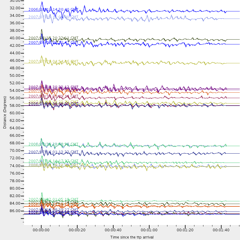
Events Processed for this Station
Download zip of receiver functions as SAC
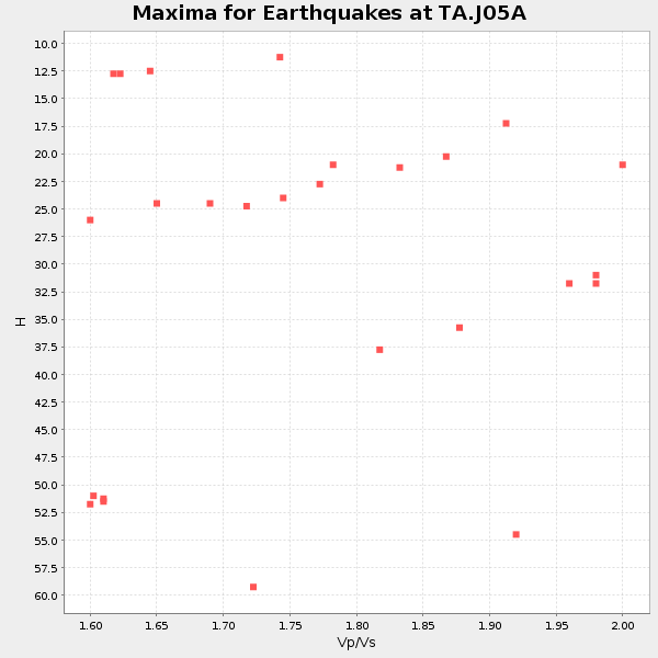
Plot maxima for each earthquake.
Events Used in the Stack
(26 events)| Radial Match | Distance | Baz | FERegion | Time | Lat/Lon | Depth | Magnitude |
| 96.88554 | 85.8 deg | 249.964 deg | Santa Cruz Islands | 2007/09/02 01:05:18 GMT | (-11.6, 165.8) | 35 km | 5.9 MB, 7.3 MS, 7.2 MW, 6.9 ME |
| 96.826225 | 57.7 deg | 305.581 deg | Kuril Islands | 2006/11/15 11:14:13 GMT | (46.6, 153.3) | 10 km | 6.5 MB, 7.8 MS, 8.3 MW, 7.9 MW |
| 96.251686 | 89.8 deg | 258.226 deg | Solomon Islands | 2007/04/01 20:39:56 GMT | (-8.5, 157.0) | 10 km | 6.8 MB, 7.9 MS, 8.1 MW, 7.7 ME |
| 94.32237 | 55.5 deg | 123.847 deg | Near West Coast Of Colombia | 2007/09/10 01:49:14 GMT | (3.0, -78.0) | 31 km | 6.1 MB, 6.7 MS, 6.8 MW |
| 93.71031 | 57.1 deg | 304.702 deg | East Of Kuril Islands | 2007/01/13 04:23:21 GMT | (46.2, 154.5) | 10 km | 7.3 MB, 8.2 MS, 8.1 MW, 7.9 MW |
| 93.687256 | 87.4 deg | 245.862 deg | Vanuatu Islands | 2007/08/01 17:08:51 GMT | (-15.6, 167.7) | 120 km | 6.2 MB, 7.2 MW, 7.2 MW |
| 93.1705 | 89.0 deg | 255.585 deg | Solomon Islands | 2007/08/16 08:39:27 GMT | (-9.8, 159.5) | 10 km | 6.1 MB, 6.7 MS, 6.4 MW |
| 91.45187 | 52.8 deg | 310.064 deg | Kamchatka Peninsula, Russia | 2007/05/30 20:22:12 GMT | (52.1, 157.3) | 116 km | 6.4 MB, 6.4 MW, 6.4 MW |
| 91.08046 | 69.6 deg | 133.158 deg | Near Coast Of Peru | 2007/08/15 23:40:57 GMT | (-13.4, -76.6) | 39 km | 6.7 MB, 7.9 MS, 8.0 MW, 7.5 ME |
| 90.71383 | 39.7 deg | 302.81 deg | Andreanof Islands, Aleutian Is. | 2007/08/02 03:21:42 GMT | (51.3, -180.0) | 21 km | 6.3 MB, 6.6 MS, 6.7 MW, 6.6 MW |
| 89.4079 | 53.1 deg | 308.865 deg | Near East Coast Of Kamchatka | 2006/08/24 21:50:36 GMT | (51.1, 157.5) | 43 km | 5.9 MB, 6.2 MS, 6.5 MW, 6.5 MW |
| 89.35021 | 75.6 deg | 230.099 deg | Samoa Islands Region | 2006/09/28 06:22:09 GMT | (-16.6, -172.0) | 28 km | 6.5 MB, 6.6 MS, 6.9 MW, 6.7 MW |
| 89.309845 | 86.6 deg | 245.366 deg | Vanuatu Islands | 2007/07/15 09:27:34 GMT | (-15.4, 168.6) | 8.0 km | 6.0 MB, 5.8 MS, 6.1 MW, 6.0 MW |
| 88.28326 | 32.2 deg | 303.196 deg | Fox Islands, Aleutian Islands | 2007/07/15 13:08:00 GMT | (52.5, -168.0) | 10 km | 5.8 MB, 5.9 MS, 6.1 MW, 6.0 MW |
| 88.15325 | 87.4 deg | 245.653 deg | Vanuatu Islands | 2006/08/07 22:18:54 GMT | (-15.8, 167.8) | 141 km | 6.0 MB, 6.8 MW, 6.8 MW |
| 88.149536 | 89.5 deg | 239.615 deg | Southeast Of Loyalty Islands | 2007/07/27 14:46:26 GMT | (-21.5, 170.9) | 10 km | 6.0 MB, 6.0 MS, 6.1 MW, 6.1 MW |
| 86.7766 | 74.5 deg | 306.072 deg | Sea Of Japan | 2007/07/16 14:17:37 GMT | (36.8, 134.9) | 350 km | 6.2 MB, 6.8 MW, 6.8 MW |
| 85.53332 | 89.7 deg | 260.497 deg | Solomon Islands | 2006/09/01 10:18:51 GMT | (-6.8, 155.5) | 38 km | 6.3 MB, 6.7 MS, 6.8 MW, 6.7 MW |
| 85.37665 | 53.9 deg | 123.175 deg | South Of Panama | 2007/03/18 02:11:05 GMT | (4.6, -78.5) | 8.0 km | 6.4 MB, 5.7 MS, 6.2 MW, 6.1 MW |
| 85.221375 | 57.8 deg | 305.467 deg | Kuril Islands | 2006/10/01 09:06:02 GMT | (46.5, 153.2) | 19 km | 6.1 MB, 6.4 MS, 6.6 MW, 6.5 MW |
| 84.31478 | 30.0 deg | 139.068 deg | Guerrero, Mexico | 2006/08/11 14:30:40 GMT | (18.6, -101.1) | 60 km | 6.0 MB, 6.1 MW, 6.0 MW |
| 82.76984 | 71.9 deg | 304.638 deg | Near West Coast Of Honshu, Japan | 2007/07/16 01:13:22 GMT | (37.5, 138.4) | 12 km | 6.5 MB, 6.4 MS, 6.6 MW, 6.5 MW |
| 82.53022 | 45.2 deg | 308.436 deg | Komandorskiye Ostrova Region | 2007/07/29 04:54:36 GMT | (53.6, 169.7) | 26 km | 6.0 MB, 5.5 MS, 5.9 MW, 5.8 MW |
| 81.44275 | 69.6 deg | 133.264 deg | Near Coast Of Peru | 2006/10/20 10:48:56 GMT | (-13.5, -76.7) | 23 km | 5.9 MB, 6.6 MS, 6.7 MW, 6.6 MW |
| 81.229836 | 38.4 deg | 300.772 deg | Andreanof Islands, Aleutian Is. | 2007/08/15 20:22:11 GMT | (50.3, -177.5) | 9.0 km | 6.3 MB, 6.2 MS, 6.4 MW, 5.9 ML |
| 81.12146 | 75.8 deg | 292.477 deg | Bonin Islands, Japan Region | 2006/08/06 18:16:40 GMT | (26.1, 144.0) | 23 km | 6.0 MB, 5.6 MS, 5.8 MW, 5.8 MW |
Losers
(0 events)| Radial Match | Distance | Baz | FERegion | Time | Lat/Lon | Depth | Magnitude | Reason |
