You are here: Home > Network List > TA - USArray Transportable Network (new EarthScope stations) Stations List
> Station J05A Fort Rock, OR, USA > Earthquake Result Viewer
J05A Fort Rock, OR, USA - Earthquake Result Viewer
| Earthquake location: |
Southeast Of Loyalty Islands |
| Earthquake latitude/longitude: |
-21.5/170.9 |
| Earthquake time(UTC): |
2007/07/27 (208) 14:46:26 GMT |
| Earthquake Depth: |
10 km |
| Earthquake Magnitude: |
6.0 MB, 6.0 MS, 6.1 MW, 6.1 MW |
| Earthquake Catalog/Contributor: |
WHDF/NEIC |
|
| Network: |
TA USArray Transportable Network (new EarthScope stations) |
| Station: |
J05A Fort Rock, OR, USA |
| Lat/Lon: |
43.28 N/121.24 W |
| Elevation: |
1540 m |
|
| Distance: |
89.5 deg |
| Az: |
42.553 deg |
| Baz: |
239.615 deg |
| Ray Param: |
0.041785643 |
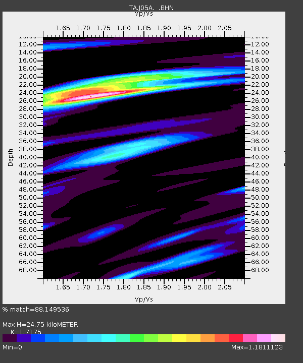
| Estimated Moho Depth: |
24.75 km |
| Estimated Crust Vp/Vs: |
1.72 |
| Assumed Crust Vp: |
6.597 km/s |
| Estimated Crust Vs: |
3.841 km/s |
| Estimated Crust Poisson's Ratio: |
0.24 |
|
| Radial Match: |
88.149536 % |
| Radial Bump: |
400 |
| Transverse Match: |
77.22577 % |
| Transverse Bump: |
400 |
| SOD ConfigId: |
2564 |
| Insert Time: |
2010-03-07 03:33:39.236 +0000 |
| GWidth: |
2.5 |
| Max Bumps: |
400 |
| Tol: |
0.001 |
|
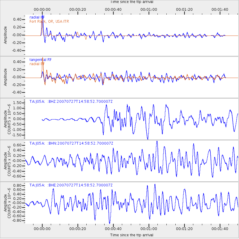
Signal To Noise
| Channel | StoN | STA | LTA |
| TA:J05A: :BHN:20070727T14:58:52.700007Z | 1.3240886 | 1.19020996E-7 | 8.9889E-8 |
| TA:J05A: :BHE:20070727T14:58:52.700007Z | 2.2663617 | 1.8607939E-7 | 8.21049E-8 |
| TA:J05A: :BHZ:20070727T14:58:52.700007Z | 7.5867443 | 4.4804457E-7 | 5.9056237E-8 |
| Arrivals |
| Ps | 2.8 SECOND |
| PpPs | 10.0 SECOND |
| PsPs/PpSs | 13 SECOND |


