You are here: Home > Network List > TA - USArray Transportable Network (new EarthScope stations) Stations List
> Station J05A Fort Rock, OR, USA > Earthquake Result Viewer
J05A Fort Rock, OR, USA - Earthquake Result Viewer
| Earthquake location: |
Solomon Islands |
| Earthquake latitude/longitude: |
-8.5/157.0 |
| Earthquake time(UTC): |
2007/04/01 (091) 20:39:56 GMT |
| Earthquake Depth: |
10 km |
| Earthquake Magnitude: |
6.8 MB, 7.9 MS, 8.1 MW, 7.7 ME |
| Earthquake Catalog/Contributor: |
WHDF/NEIC |
|
| Network: |
TA USArray Transportable Network (new EarthScope stations) |
| Station: |
J05A Fort Rock, OR, USA |
| Lat/Lon: |
43.28 N/121.24 W |
| Elevation: |
1540 m |
|
| Distance: |
89.8 deg |
| Az: |
46.274 deg |
| Baz: |
258.226 deg |
| Ray Param: |
0.041721705 |
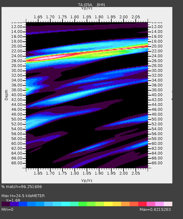
| Estimated Moho Depth: |
24.5 km |
| Estimated Crust Vp/Vs: |
1.69 |
| Assumed Crust Vp: |
6.597 km/s |
| Estimated Crust Vs: |
3.904 km/s |
| Estimated Crust Poisson's Ratio: |
0.23 |
|
| Radial Match: |
96.251686 % |
| Radial Bump: |
400 |
| Transverse Match: |
90.49189 % |
| Transverse Bump: |
400 |
| SOD ConfigId: |
2564 |
| Insert Time: |
2010-03-07 03:33:49.611 +0000 |
| GWidth: |
2.5 |
| Max Bumps: |
400 |
| Tol: |
0.001 |
|
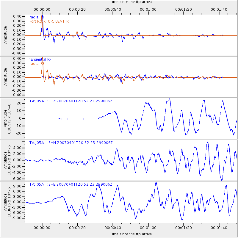
Signal To Noise
| Channel | StoN | STA | LTA |
| TA:J05A: :BHN:20070401T20:52:23.299006Z | 1.1793075 | 1.7957875E-7 | 1.5227474E-7 |
| TA:J05A: :BHE:20070401T20:52:23.299006Z | 2.1963196 | 5.1240124E-7 | 2.3329996E-7 |
| TA:J05A: :BHZ:20070401T20:52:23.299006Z | 9.402146 | 1.7016064E-6 | 1.8098063E-7 |
| Arrivals |
| Ps | 2.6 SECOND |
| PpPs | 9.8 SECOND |
| PsPs/PpSs | 12 SECOND |


