You are here: Home > Network List > TA - USArray Transportable Network (new EarthScope stations) Stations List
> Station J05A Fort Rock, OR, USA > Earthquake Result Viewer
J05A Fort Rock, OR, USA - Earthquake Result Viewer
| Earthquake location: |
Near East Coast Of Kamchatka |
| Earthquake latitude/longitude: |
51.1/157.5 |
| Earthquake time(UTC): |
2006/08/24 (236) 21:50:36 GMT |
| Earthquake Depth: |
43 km |
| Earthquake Magnitude: |
5.9 MB, 6.2 MS, 6.5 MW, 6.5 MW |
| Earthquake Catalog/Contributor: |
WHDF/NEIC |
|
| Network: |
TA USArray Transportable Network (new EarthScope stations) |
| Station: |
J05A Fort Rock, OR, USA |
| Lat/Lon: |
43.28 N/121.24 W |
| Elevation: |
1540 m |
|
| Distance: |
53.1 deg |
| Az: |
64.52 deg |
| Baz: |
308.865 deg |
| Ray Param: |
0.066238455 |
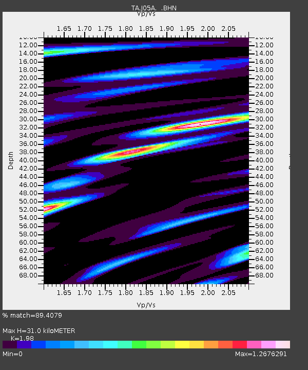
| Estimated Moho Depth: |
31.0 km |
| Estimated Crust Vp/Vs: |
1.98 |
| Assumed Crust Vp: |
6.597 km/s |
| Estimated Crust Vs: |
3.332 km/s |
| Estimated Crust Poisson's Ratio: |
0.33 |
|
| Radial Match: |
89.4079 % |
| Radial Bump: |
400 |
| Transverse Match: |
82.51442 % |
| Transverse Bump: |
400 |
| SOD ConfigId: |
2665 |
| Insert Time: |
2010-03-07 03:34:04.945 +0000 |
| GWidth: |
2.5 |
| Max Bumps: |
400 |
| Tol: |
0.001 |
|

Signal To Noise
| Channel | StoN | STA | LTA |
| TA:J05A: :BHN:20060824T21:59:19.100012Z | 8.678567 | 9.4891584E-7 | 1.0934016E-7 |
| TA:J05A: :BHE:20060824T21:59:19.100012Z | 17.695238 | 1.3936776E-6 | 7.876003E-8 |
| TA:J05A: :BHZ:20060824T21:59:19.100012Z | 68.250946 | 3.6325298E-6 | 5.322314E-8 |
| Arrivals |
| Ps | 4.8 SECOND |
| PpPs | 13 SECOND |
| PsPs/PpSs | 18 SECOND |


