You are here: Home > Network List > TA - USArray Transportable Network (new EarthScope stations) Stations List
> Station J05A Fort Rock, OR, USA > Earthquake Result Viewer
J05A Fort Rock, OR, USA - Earthquake Result Viewer
| Earthquake location: |
Vanuatu Islands |
| Earthquake latitude/longitude: |
-15.8/167.8 |
| Earthquake time(UTC): |
2006/08/07 (219) 22:18:54 GMT |
| Earthquake Depth: |
141 km |
| Earthquake Magnitude: |
6.0 MB, 6.8 MW, 6.8 MW |
| Earthquake Catalog/Contributor: |
WHDF/NEIC |
|
| Network: |
TA USArray Transportable Network (new EarthScope stations) |
| Station: |
J05A Fort Rock, OR, USA |
| Lat/Lon: |
43.28 N/121.24 W |
| Elevation: |
1540 m |
|
| Distance: |
87.4 deg |
| Az: |
43.711 deg |
| Baz: |
245.653 deg |
| Ray Param: |
0.04301499 |
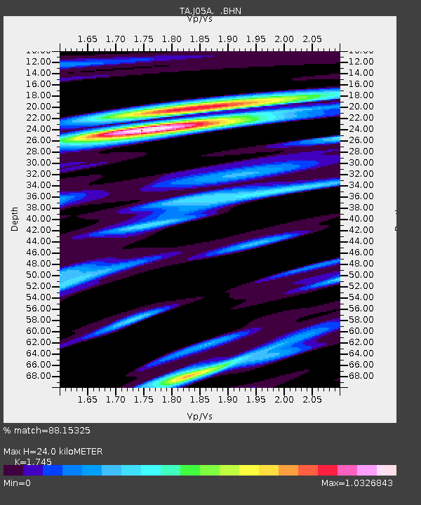
| Estimated Moho Depth: |
24.0 km |
| Estimated Crust Vp/Vs: |
1.75 |
| Assumed Crust Vp: |
6.597 km/s |
| Estimated Crust Vs: |
3.781 km/s |
| Estimated Crust Poisson's Ratio: |
0.26 |
|
| Radial Match: |
88.15325 % |
| Radial Bump: |
400 |
| Transverse Match: |
83.759926 % |
| Transverse Bump: |
400 |
| SOD ConfigId: |
2665 |
| Insert Time: |
2010-03-07 03:34:08.386 +0000 |
| GWidth: |
2.5 |
| Max Bumps: |
400 |
| Tol: |
0.001 |
|

Signal To Noise
| Channel | StoN | STA | LTA |
| TA:J05A: :BHN:20060807T22:30:54.350017Z | 0.70497084 | 1.437876E-7 | 2.0396249E-7 |
| TA:J05A: :BHE:20060807T22:30:54.350017Z | 3.627664 | 4.529632E-7 | 1.248636E-7 |
| TA:J05A: :BHZ:20060807T22:30:54.350017Z | 17.225224 | 1.8928837E-6 | 1.0989022E-7 |
| Arrivals |
| Ps | 2.8 SECOND |
| PpPs | 9.8 SECOND |
| PsPs/PpSs | 13 SECOND |


