You are here: Home > Network List > TA - USArray Transportable Network (new EarthScope stations) Stations List
> Station N07A Gerlach, NV, USA > Earthquake Result Viewer
N07A Gerlach, NV, USA - Earthquake Result Viewer
| Earthquake location: |
Fiji Islands Region |
| Earthquake latitude/longitude: |
-18.0/-179.6 |
| Earthquake time(UTC): |
2006/02/24 (055) 14:15:45 GMT |
| Earthquake Depth: |
622 km |
| Earthquake Magnitude: |
5.9 MB, 6.1 MW, 6.0 MW |
| Earthquake Catalog/Contributor: |
WHDF/NEIC |
|
| Network: |
TA USArray Transportable Network (new EarthScope stations) |
| Station: |
N07A Gerlach, NV, USA |
| Lat/Lon: |
40.77 N/118.97 W |
| Elevation: |
1306 m |
|
| Distance: |
81.1 deg |
| Az: |
42.057 deg |
| Baz: |
237.077 deg |
| Ray Param: |
0.045898773 |
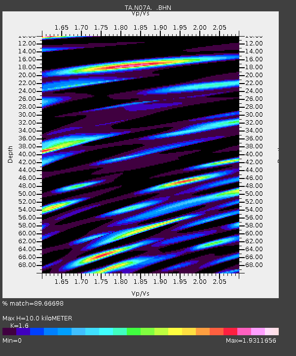
| Estimated Moho Depth: |
10.0 km |
| Estimated Crust Vp/Vs: |
1.60 |
| Assumed Crust Vp: |
6.276 km/s |
| Estimated Crust Vs: |
3.922 km/s |
| Estimated Crust Poisson's Ratio: |
0.18 |
|
| Radial Match: |
89.66698 % |
| Radial Bump: |
400 |
| Transverse Match: |
76.85064 % |
| Transverse Bump: |
400 |
| SOD ConfigId: |
2422 |
| Insert Time: |
2010-03-07 03:34:15.697 +0000 |
| GWidth: |
2.5 |
| Max Bumps: |
400 |
| Tol: |
0.001 |
|

Signal To Noise
| Channel | StoN | STA | LTA |
| TA:N07A: :BHN:20060224T14:26:25.900002Z | 4.8983107 | 7.710146E-7 | 1.5740417E-7 |
| TA:N07A: :BHE:20060224T14:26:25.900002Z | 10.879946 | 1.1111385E-6 | 1.0212721E-7 |
| TA:N07A: :BHZ:20060224T14:26:25.900002Z | 25.203814 | 2.3402604E-6 | 9.2853426E-8 |
| Arrivals |
| Ps | 1.0 SECOND |
| PpPs | 4.0 SECOND |
| PsPs/PpSs | 5.0 SECOND |


