
Station TA N07A - Gerlach, NV, USA
Network: TA - USArray Transportable Network (new EarthScope stations)
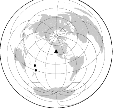
Nearby stations (2 deg radius)
| Station | Name | (Lat, Lon) | Start / End | Elevation |
| N07A | Gerlach, NV, USA | (40.77, -118.97) | 2006-02-21 / 2006-04-28 | 1.3 km |
| Crust2 Type: | M5,extended crust, 0.5 km seds. |
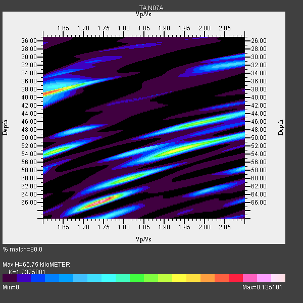
| Thickness Estimate: | 66 km |
| Thickness StdDev: | 11 km |
| Vp/Vs Estimate: | 1.74 |
| Vp/Vs StdDev: | 0.11 |
| Vs Estimate: | 3.612 km/s |
| Poisson's Ratio: | 0.25 |
| Peak Value: | 0.14 |
| Assumed Vp: | 6.276 km/s |
| Ps Weight: | 0.33333334 |
| PpPs Weight: | 0.33333334 |
| PsPs Weight: | 0.33333328 |
| Residual Complexity: | 0.822 |
| Nearby stations H: | 46 km +- 28 km |
| (2.0 deg) Vp/Vs: | 1.81 +- 0.10 |
1 with match > 90% ( 50.0 %) and 2 with match > 80% ( 100.0 %) out of 2.
Download stack as xyz text file.
Azimuth Distribution of Events:
Prior Results for this Station
| Study | Thickness | Vp/Vs | Vp | Vs | Poissons Ratio | Extra |
| EARS | 66 km | 1.74 | 6.276 km/s | 3.612 km/s | 0.25 | |
| Crust2.0 | 31 km | 1.78 | 6.276 km/s | 3.529 km/s | 0.27 | M5,extended crust, 0.5 km seds. |
| Global Maxima | 66 km | 1.74 | 6.276 km/s | 3.612 km/s | 0.25 | amp=0.135101 |
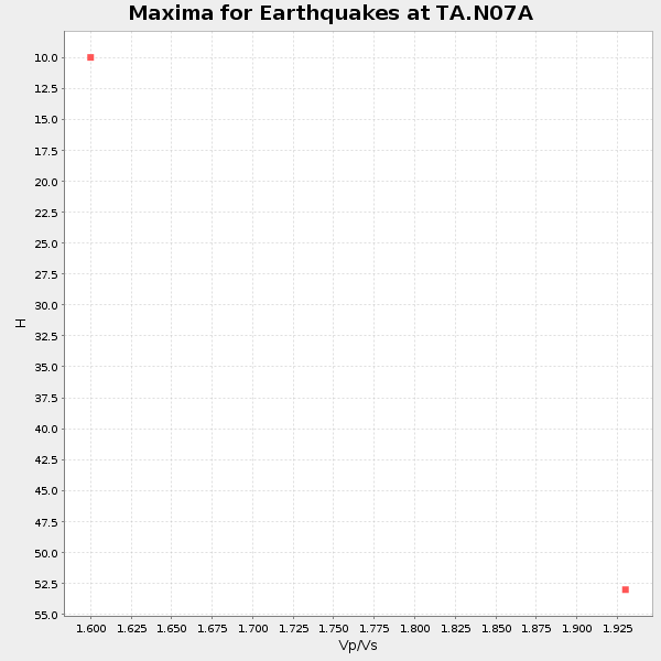
| Local Maxima 1 | 38 km | 1.62 | 6.276 km/s | 3.874 km/s | 0.19 | amp=0.108177595 |
| Local Maxima 2 | 53 km | 1.63 | 6.276 km/s | 3.85 km/s | 0.20 | amp=0.07927018 |
| Local Maxima 3 | 52 km | 1.96 | 6.276 km/s | 3.206 km/s | 0.32 | amp=0.0763674 |
| Local Maxima 4 | 46 km | 1.99 | 6.276 km/s | 3.154 km/s | 0.33 | amp=0.06799413 |
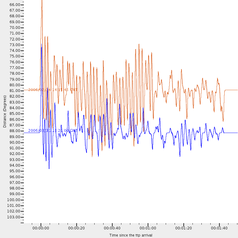
| Predicted Arrivals for vertical incidence (zero ray parameter) | |
| Ps | 7.73 SECOND |
| PpPs | 28.68 SECOND |
| PsPs/PpSs | 36.41 SECOND |
Events Processed for this Station
Download zip of receiver functions as SAC
Plot maxima for each earthquake.
Events Used in the Stack
(2 events)| Radial Match | Distance | Baz | FERegion | Time | Lat/Lon | Depth | Magnitude |
| 91.0533 | 88.2 deg | 227.537 deg | Kermadec Islands Region | 2006/03/31 13:21:00 GMT | (-29.6, -176.8) | 17 km | 5.9 MB, 6.7 MS, 6.5 MW, 6.5 MW |
| 89.66698 | 81.1 deg | 237.077 deg | Fiji Islands Region | 2006/02/24 14:15:45 GMT | (-18.0, -179.6) | 622 km | 5.9 MB, 6.1 MW, 6.0 MW |
Losers
(0 events)| Radial Match | Distance | Baz | FERegion | Time | Lat/Lon | Depth | Magnitude | Reason |
