You are here: Home > Network List > TA - USArray Transportable Network (new EarthScope stations) Stations List
> Station G05A Wamic, OR, USA > Earthquake Result Viewer
G05A Wamic, OR, USA - Earthquake Result Viewer
| Earthquake location: |
Volcano Islands, Japan Region |
| Earthquake latitude/longitude: |
22.0/142.7 |
| Earthquake time(UTC): |
2007/09/28 (271) 13:38:59 GMT |
| Earthquake Depth: |
276 km |
| Earthquake Magnitude: |
6.7 MB, 7.4 MW, 7.4 MW |
| Earthquake Catalog/Contributor: |
WHDF/NEIC |
|
| Network: |
TA USArray Transportable Network (new EarthScope stations) |
| Station: |
G05A Wamic, OR, USA |
| Lat/Lon: |
45.24 N/121.32 W |
| Elevation: |
594 m |
|
| Distance: |
78.8 deg |
| Az: |
45.749 deg |
| Baz: |
289.797 deg |
| Ray Param: |
0.048685096 |
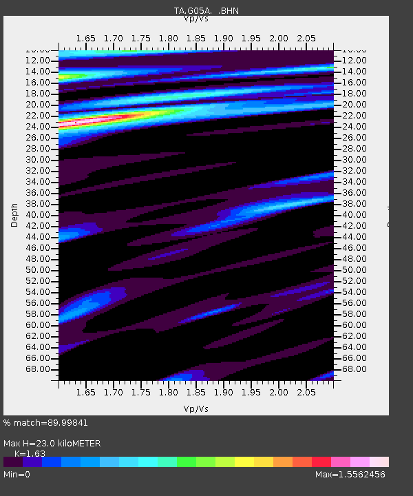
| Estimated Moho Depth: |
23.0 km |
| Estimated Crust Vp/Vs: |
1.63 |
| Assumed Crust Vp: |
6.597 km/s |
| Estimated Crust Vs: |
4.048 km/s |
| Estimated Crust Poisson's Ratio: |
0.20 |
|
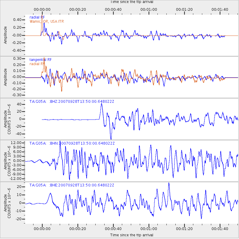
| Radial Match: |
89.99841 % |
| Radial Bump: |
400 |
| Transverse Match: |
79.67779 % |
| Transverse Bump: |
400 |
| SOD ConfigId: |
2564 |
| Insert Time: |
2010-03-07 03:34:21.711 +0000 |
| GWidth: |
2.5 |
| Max Bumps: |
400 |
| Tol: |
0.001 |
|
Signal To Noise
| Channel | StoN | STA | LTA |
| TA:G05A: :BHN:20070928T13:50:00.648022Z | 5.0957 | 1.2944555E-6 | 2.54029E-7 |
| TA:G05A: :BHE:20070928T13:50:00.648022Z | 12.656486 | 5.350141E-6 | 4.2271932E-7 |
| TA:G05A: :BHZ:20070928T13:50:00.648022Z | 51.453983 | 1.756652E-5 | 3.4140248E-7 |
| Arrivals |
| Ps | 2.3 SECOND |
| PpPs | 8.9 SECOND |
| PsPs/PpSs | 11 SECOND |


