
Station TA G05A - Wamic, OR, USA
Network: TA - USArray Transportable Network (new EarthScope stations)
Nearby stations (2 deg radius)
| Station | Name | (Lat, Lon) | Start / End | Elevation |
| G05A | Wamic, OR, USA | (45.24, -121.32) | 2005-11-03 / 2499-01-01 | 0.6 km |
| Crust2 Type: | L3,continental arc, Southern Andes, 0.2 km seds. |
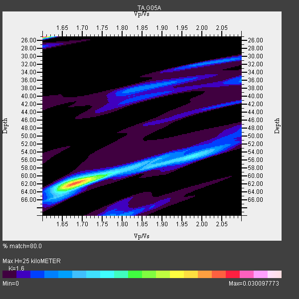
| Thickness Estimate: | 25 km |
| Thickness StdDev: | 18 km |
| Vp/Vs Estimate: | 1.60 |
| Vp/Vs StdDev: | 0.08 |
| Vs Estimate: | 4.123 km/s |
| Poisson's Ratio: | 0.18 |
| Peak Value: | 0.03 |
| Assumed Vp: | 6.597 km/s |
| Ps Weight: | 0.33333334 |
| PpPs Weight: | 0.33333334 |
| PsPs Weight: | 0.33333328 |
| Residual Complexity: | 0.982 |
| Nearby stations H: | +- |
| (2.0 deg) Vp/Vs: | +- |
2 with match > 90% ( 20.0 %) and 8 with match > 80% ( 80.0 %) out of 10.
Download stack as xyz text file.
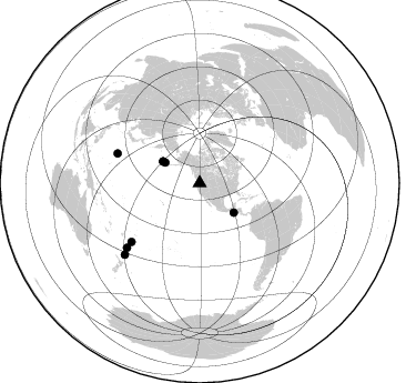
Azimuth Distribution of Events:
Prior Results for this Station
| Study | Thickness | Vp/Vs | Vp | Vs | Poissons Ratio | Extra |
| EARS | 25 km | 1.60 | 6.597 km/s | 4.123 km/s | 0.18 | |
| Crust2.0 | 40 km | 1.77 | 6.597 km/s | 3.723 km/s | 0.27 | L3,continental arc, Southern Andes, 0.2 km seds. |
| Global Maxima | 25 km | 1.60 | 6.597 km/s | 4.123 km/s | 0.18 | amp=0.030097773 |
| Local Maxima 1 | 62 km | 1.68 | 6.597 km/s | 3.921 km/s | 0.23 | amp=0.023646964 |
| Local Maxima 2 | 54 km | 1.99 | 6.597 km/s | 3.324 km/s | 0.33 | amp=0.009530523 |
| Local Maxima 3 | 65 km | 1.63 | 6.597 km/s | 4.048 km/s | 0.20 | amp=0.006681448 |
| Local Maxima 4 | 58 km | 1.83 | 6.597 km/s | 3.605 km/s | 0.29 | amp=0.006005344 |
| Predicted Arrivals for vertical incidence (zero ray parameter) | |
| Ps | 2.27 SECOND |
| PpPs | 9.85 SECOND |
| PsPs/PpSs | 12.13 SECOND |
Events Processed for this Station
Download zip of receiver functions as SAC
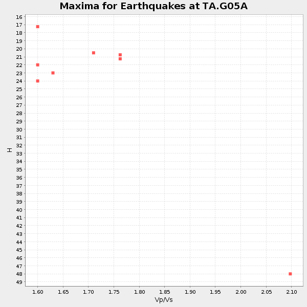
Plot maxima for each earthquake.
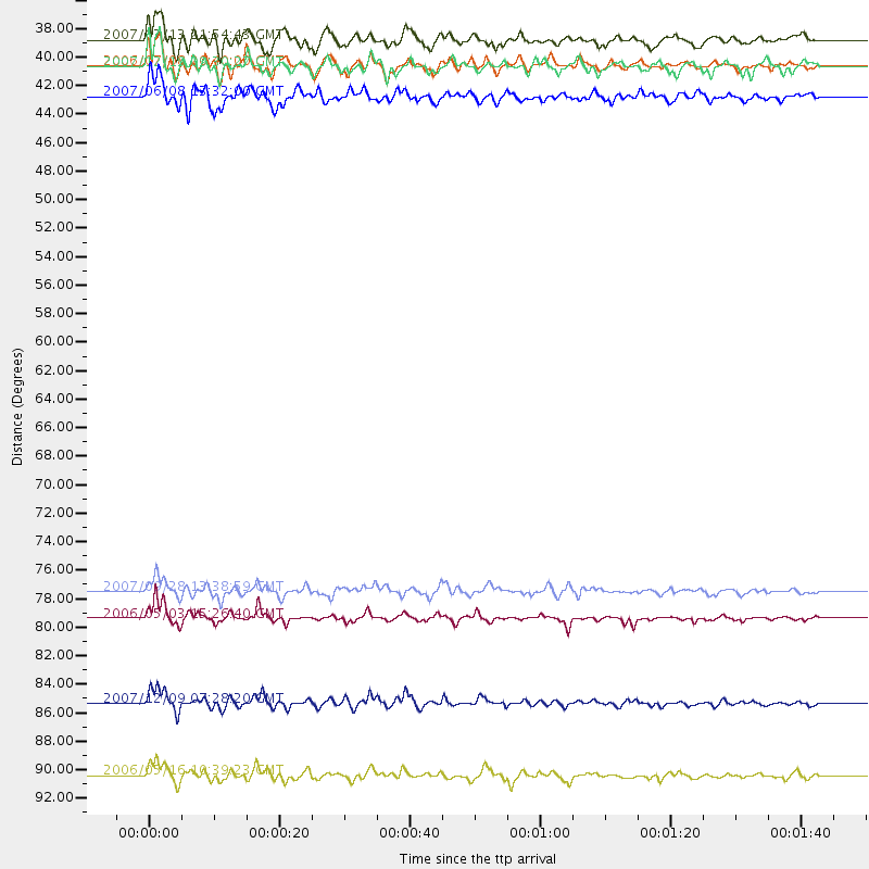
Events Used in the Stack
(8 events)| Radial Match | Distance | Baz | FERegion | Time | Lat/Lon | Depth | Magnitude |
| 95.295 | 80.9 deg | 229.273 deg | Tonga Islands | 2006/05/03 15:26:40 GMT | (-20.2, -174.1) | 55 km | 7.2 MB, 7.8 MS, 7.9 MW, 7.9 MW |
| 90.5705 | 87.4 deg | 228.47 deg | South Of Fiji Islands | 2007/12/09 07:28:20 GMT | (-26.0, -177.5) | 152 km | 7.0 MB, 7.8 MW, 7.7 MW |
| 89.99841 | 78.8 deg | 289.797 deg | Volcano Islands, Japan Region | 2007/09/28 13:38:59 GMT | (22.0, 142.7) | 276 km | 6.7 MB, 7.4 MW, 7.4 MW |
| 84.12628 | 93.0 deg | 226.319 deg | Kermadec Islands Region | 2006/05/16 10:39:23 GMT | (-31.8, -179.3) | 152 km | 6.8 MB, 7.4 MW, 7.4 MW |
| 81.54505 | 40.6 deg | 130.664 deg | Near Coast Of Guatemala | 2007/06/08 13:32:00 GMT | (13.8, -90.8) | 48 km | 5.5 MB, 5.4 MS, 5.8 MW, 5.8 MW |
| 80.622185 | 38.3 deg | 300.719 deg | Andreanof Islands, Aleutian Is. | 2007/12/19 09:30:27 GMT | (51.4, -179.5) | 29 km | 6.4 MB, 7.1 MS, 7.1 MW, 7.0 MW |
| 80.53255 | 36.2 deg | 300.728 deg | Andreanof Islands, Aleutian Is. | 2007/07/13 21:54:43 GMT | (51.8, -176.3) | 35 km | 5.7 MB, 5.6 MS, 6.0 MW, 5.9 MW |
| 80.2053 | 38.2 deg | 300.433 deg | Andreanof Islands, Aleutian Is. | 2006/07/08 20:40:00 GMT | (51.2, -179.3) | 22 km | 6.2 MB, 6.4 MS, 6.6 MW, 6.6 MW |
Losers
(2 events)| Radial Match | Distance | Baz | FERegion | Time | Lat/Lon | Depth | Magnitude | Reason |
| 64.23553 | 80.5 deg | 130.999 deg | Chile-Bolivia Border Region | 2008/03/24 20:39:07 GMT | (-20.0, -69.0) | 120 km | 5.7 MB, 6.2 MW, 6.1 MW | |
| 62.365856 | 97.0 deg | 341.433 deg | Southern Xinjiang, China | 2008/03/20 22:32:57 GMT | (35.5, 81.5) | 10 km | 6.3 MB, 7.3 MS, 7.2 MW, 7.1 MW |
