You are here: Home > Network List > TA - USArray Transportable Network (new EarthScope stations) Stations List
> Station G05A Wamic, OR, USA > Earthquake Result Viewer
G05A Wamic, OR, USA - Earthquake Result Viewer
| Earthquake location: |
Near Coast Of Guatemala |
| Earthquake latitude/longitude: |
13.8/-90.8 |
| Earthquake time(UTC): |
2007/06/08 (159) 13:32:00 GMT |
| Earthquake Depth: |
48 km |
| Earthquake Magnitude: |
5.5 MB, 5.4 MS, 5.8 MW, 5.8 MW |
| Earthquake Catalog/Contributor: |
WHDF/NEIC |
|
| Network: |
TA USArray Transportable Network (new EarthScope stations) |
| Station: |
G05A Wamic, OR, USA |
| Lat/Lon: |
45.24 N/121.32 W |
| Elevation: |
594 m |
|
| Distance: |
40.6 deg |
| Az: |
326.516 deg |
| Baz: |
130.664 deg |
| Ray Param: |
0.074177906 |
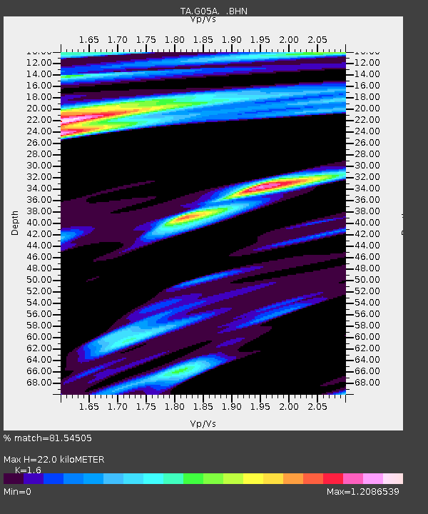
| Estimated Moho Depth: |
22.0 km |
| Estimated Crust Vp/Vs: |
1.60 |
| Assumed Crust Vp: |
6.597 km/s |
| Estimated Crust Vs: |
4.123 km/s |
| Estimated Crust Poisson's Ratio: |
0.18 |
|
| Radial Match: |
81.54505 % |
| Radial Bump: |
400 |
| Transverse Match: |
69.96338 % |
| Transverse Bump: |
400 |
| SOD ConfigId: |
2564 |
| Insert Time: |
2010-03-07 03:34:24.536 +0000 |
| GWidth: |
2.5 |
| Max Bumps: |
400 |
| Tol: |
0.001 |
|

Signal To Noise
| Channel | StoN | STA | LTA |
| TA:G05A: :BHN:20070608T13:39:05.500011Z | 2.0128655 | 3.4147197E-7 | 1.696447E-7 |
| TA:G05A: :BHE:20070608T13:39:05.500011Z | 3.315253 | 4.6180313E-7 | 1.3929649E-7 |
| TA:G05A: :BHZ:20070608T13:39:05.500011Z | 7.8797016 | 1.4136697E-6 | 1.794065E-7 |
| Arrivals |
| Ps | 2.2 SECOND |
| PpPs | 8.0 SECOND |
| PsPs/PpSs | 10 SECOND |


