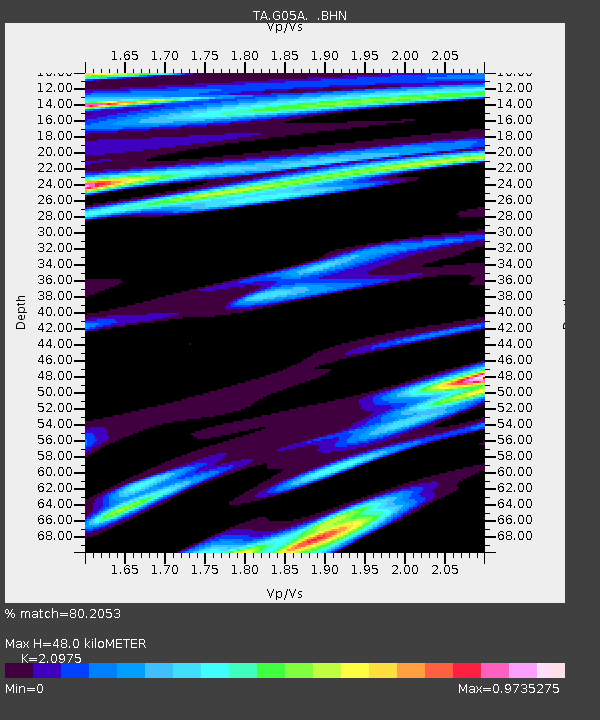
G05A Wamic, OR, USA - Earthquake Result Viewer

Earthquake location: Andreanof Islands, Aleutian Is.
Earthquake latitude/longitude: 51.2/-179.3
Earthquake time(UTC): 2006/07/08 (189) 20:40:00 GMT
Earthquake Depth: 22 km
Earthquake Magnitude: 6.2 MB, 6.4 MS, 6.6 MW, 6.6 MW
Earthquake Catalog/Contributor: WHDF/NEIC
Network: TA USArray Transportable Network (new EarthScope stations)
Station: G05A Wamic, OR, USA
Lat/Lon: 45.24 N/121.32 W
Elevation: 594 m
Distance: 38.2 deg
Az: 75.581 deg
Baz: 300.433 deg
Ray Param: 0.075660095
Estimated Moho Depth: 48.0 km
Estimated Crust Vp/Vs: 2.10
Assumed Crust Vp: 6.597 km/s
Estimated Crust Vs: 3.145 km/s
Estimated Crust Poisson's Ratio: 0.35
Radial Match: 80.2053 %
Radial Bump: 400
Transverse Match: 59.83416 %
Transverse Bump: 400
SOD ConfigId: 2665
Insert Time: 2010-03-07 03:34:25.882 +0000
GWidth: 2.5
Max Bumps: 400
Tol: 0.001

Signal To Noise

ChannelStoNSTALTA
TA:G05A: :BHN:20060708T20:46:48.374012Z1.38203084.818961E-73.4868694E-7
TA:G05A: :BHE:20060708T20:46:48.374012Z1.26135873.8399554E-73.044301E-7
TA:G05A: :BHZ:20060708T20:46:48.374012Z4.7067081.3151761E-62.7942588E-7
Arrivals
Ps8.5 SECOND
PpPs21 SECOND
PsPs/PpSs30 SECOND