You are here: Home > Network List > TA - USArray Transportable Network (new EarthScope stations) Stations List
> Station G05A Wamic, OR, USA > Earthquake Result Viewer
G05A Wamic, OR, USA - Earthquake Result Viewer
| Earthquake location: |
Tonga Islands |
| Earthquake latitude/longitude: |
-20.2/-174.1 |
| Earthquake time(UTC): |
2006/05/03 (123) 15:26:40 GMT |
| Earthquake Depth: |
55 km |
| Earthquake Magnitude: |
7.2 MB, 7.8 MS, 7.9 MW, 7.9 MW |
| Earthquake Catalog/Contributor: |
WHDF/NEIC |
|
| Network: |
TA USArray Transportable Network (new EarthScope stations) |
| Station: |
G05A Wamic, OR, USA |
| Lat/Lon: |
45.24 N/121.32 W |
| Elevation: |
594 m |
|
| Distance: |
80.9 deg |
| Az: |
34.749 deg |
| Baz: |
229.273 deg |
| Ray Param: |
0.047870718 |
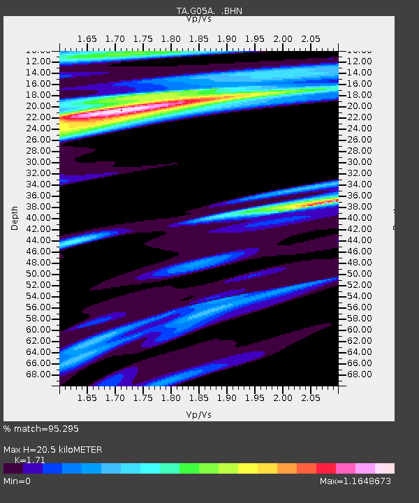
| Estimated Moho Depth: |
20.5 km |
| Estimated Crust Vp/Vs: |
1.71 |
| Assumed Crust Vp: |
6.597 km/s |
| Estimated Crust Vs: |
3.858 km/s |
| Estimated Crust Poisson's Ratio: |
0.24 |
|
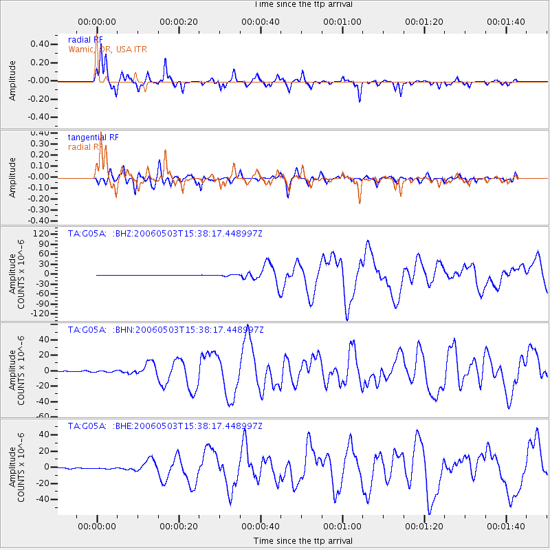
| Radial Match: |
95.295 % |
| Radial Bump: |
324 |
| Transverse Match: |
87.20126 % |
| Transverse Bump: |
400 |
| SOD ConfigId: |
2669 |
| Insert Time: |
2010-03-07 03:34:29.776 +0000 |
| GWidth: |
2.5 |
| Max Bumps: |
400 |
| Tol: |
0.001 |
|
Signal To Noise
| Channel | StoN | STA | LTA |
| TA:G05A: :BHN:20060503T15:38:17.448997Z | 2.9137955 | 8.7761214E-7 | 3.011921E-7 |
| TA:G05A: :BHE:20060503T15:38:17.448997Z | 0.9027615 | 4.5937648E-7 | 5.0885694E-7 |
| TA:G05A: :BHZ:20060503T15:38:17.448997Z | 6.9100943 | 2.0540094E-6 | 2.9724768E-7 |
| Arrivals |
| Ps | 2.3 SECOND |
| PpPs | 8.2 SECOND |
| PsPs/PpSs | 10 SECOND |


