You are here: Home > Network List > TA - USArray Transportable Network (new EarthScope stations) Stations List
> Station J12A Stokes Ranch, Hill City, ID, USA > Earthquake Result Viewer
J12A Stokes Ranch, Hill City, ID, USA - Earthquake Result Viewer

| Earthquake location: |
South Of Fiji Islands |
| Earthquake latitude/longitude: |
-25.8/179.5 |
| Earthquake time(UTC): |
2007/10/16 (289) 21:05:43 GMT |
| Earthquake Depth: |
509 km |
| Earthquake Magnitude: |
6.2 MB, 6.6 MW, 6.5 MW |
| Earthquake Catalog/Contributor: |
WHDF/NEIC |
|
| Network: |
TA USArray Transportable Network (new EarthScope stations) |
| Station: |
J12A Stokes Ranch, Hill City, ID, USA |
| Lat/Lon: |
43.25 N/115.10 W |
| Elevation: |
1587 m |
|
| Distance: |
91.2 deg |
| Az: |
41.632 deg |
| Baz: |
235.065 deg |
| Ray Param: |
0.04133694 |
| Estimated Moho Depth: |
10.0 km |
| Estimated Crust Vp/Vs: |
1.60 |
| Assumed Crust Vp: |
6.291 km/s |
| Estimated Crust Vs: |
3.932 km/s |
| Estimated Crust Poisson's Ratio: |
0.18 |
|
| Radial Match: |
89.2362 % |
| Radial Bump: |
353 |
| Transverse Match: |
84.548615 % |
| Transverse Bump: |
398 |
| SOD ConfigId: |
2564 |
| Insert Time: |
2010-03-07 03:46:12.259 +0000 |
| GWidth: |
2.5 |
| Max Bumps: |
400 |
| Tol: |
0.001 |
|
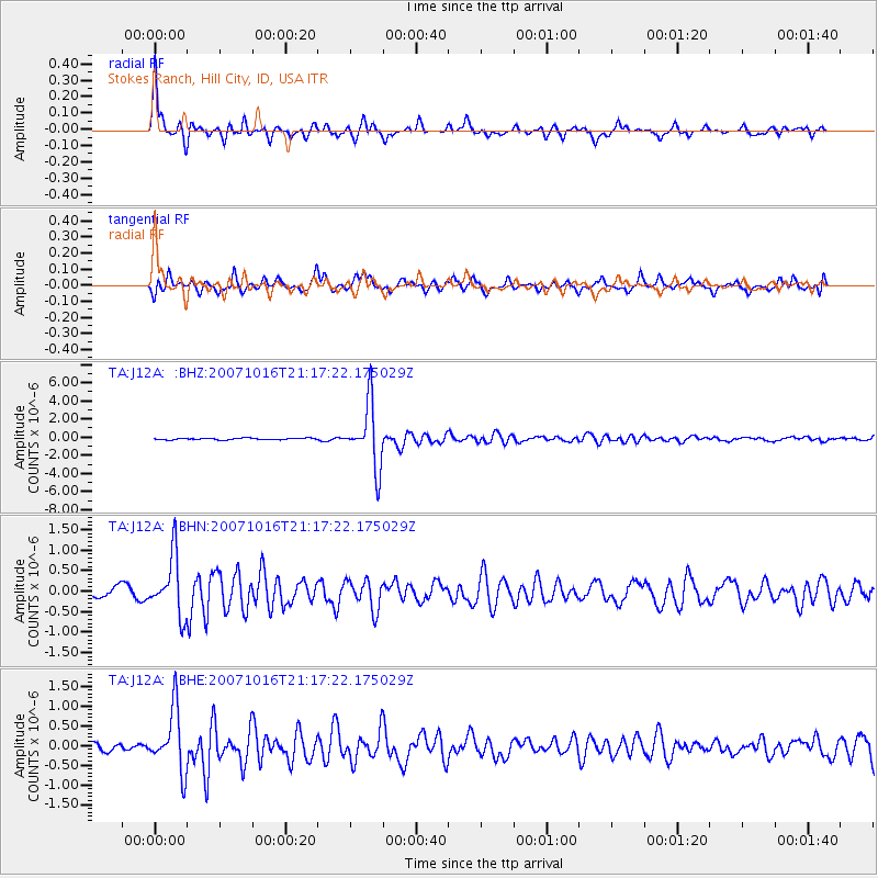
Signal To Noise
| Channel | StoN | STA | LTA |
| TA:J12A: :BHN:20071016T21:17:22.175029Z | 6.213289 | 7.1607616E-7 | 1.1524913E-7 |
| TA:J12A: :BHE:20071016T21:17:22.175029Z | 9.121183 | 7.743512E-7 | 8.4895916E-8 |
| TA:J12A: :BHZ:20071016T21:17:22.175029Z | 38.302193 | 3.439288E-6 | 8.97935E-8 |
| Arrivals |
| Ps | 1.0 SECOND |
| PpPs | 4.0 SECOND |
| PsPs/PpSs | 5.0 SECOND |


