
Station TA J12A - Stokes Ranch, Hill City, ID, USA
Network: TA - USArray Transportable Network (new EarthScope stations)
Nearby stations (2 deg radius)
| Station | Name | (Lat, Lon) | Start / End | Elevation |
| J12A | Stokes Ranch, Hill City, ID, USA | (43.25, -115.10) | 2006-12-08 / 2499-01-01 | 1.6 km |
| Crust2 Type: | M9,thick extended crust, 0.5 km seds. |
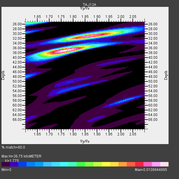
| Thickness Estimate: | 37 km |
| Thickness StdDev: | 3.0 km |
| Vp/Vs Estimate: | 1.77 |
| Vp/Vs StdDev: | 0.05 |
| Vs Estimate: | 3.544 km/s |
| Poisson's Ratio: | 0.27 |
| Peak Value: | 0.01 |
| Assumed Vp: | 6.291 km/s |
| Ps Weight: | 0.33333334 |
| PpPs Weight: | 0.33333334 |
| PsPs Weight: | 0.33333328 |
| Residual Complexity: | 0.609 |
| Nearby stations H: | +- |
| (2.0 deg) Vp/Vs: | +- |
21 with match > 90% ( 58.333332 %) and 36 with match > 80% ( 100.0 %) out of 36.
Download stack as xyz text file.
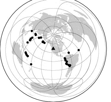
Azimuth Distribution of Events:
Prior Results for this Station
| Study | Thickness | Vp/Vs | Vp | Vs | Poissons Ratio | Extra |
| EARS | 37 km | 1.77 | 6.291 km/s | 3.544 km/s | 0.27 | |
| Crust2.0 | 40 km | 1.78 | 6.291 km/s | 3.539 km/s | 0.27 | M9,thick extended crust, 0.5 km seds. |
| Global Maxima | 37 km | 1.77 | 6.291 km/s | 3.544 km/s | 0.27 | amp=0.0108944895 |
| Local Maxima 1 | 31 km | 1.84 | 6.291 km/s | 3.419 km/s | 0.29 | amp=0.008738109 |
| Local Maxima 2 | 25 km | 1.64 | 6.291 km/s | 3.842 km/s | 0.20 | amp=0.005185459 |
| Local Maxima 3 | 39 km | 1.72 | 6.291 km/s | 3.663 km/s | 0.24 | amp=0.0031972753 |
| Local Maxima 4 | 29 km | 1.96 | 6.291 km/s | 3.206 km/s | 0.32 | amp=0.0026274354 |
| Predicted Arrivals for vertical incidence (zero ray parameter) | |
| Ps | 4.53 SECOND |
| PpPs | 16.21 SECOND |
| PsPs/PpSs | 20.74 SECOND |
Events Processed for this Station
Download zip of receiver functions as SAC
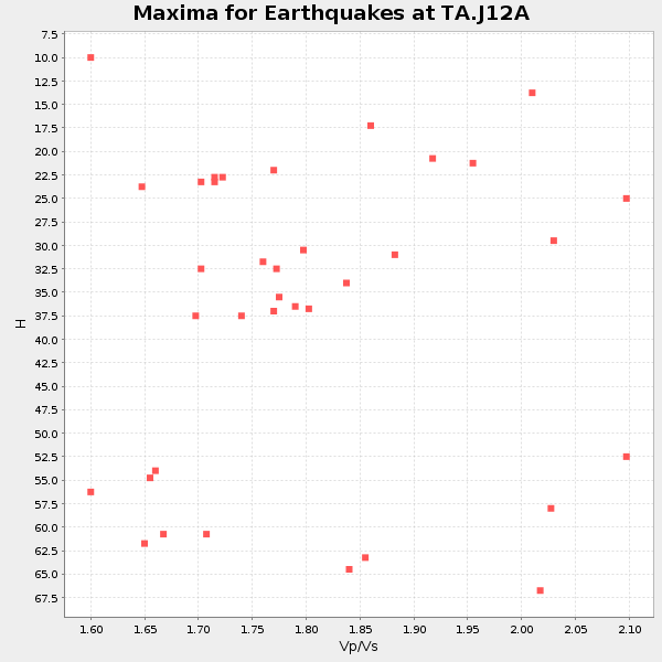
Plot maxima for each earthquake.
Events Used in the Stack
(36 events)| Radial Match | Distance | Baz | FERegion | Time | Lat/Lon | Depth | Magnitude |
| 98.317085 | 60.8 deg | 307.325 deg | East Of Kuril Islands | 2007/01/13 04:23:21 GMT | (46.2, 154.5) | 10 km | 7.3 MB, 8.2 MS, 8.1 MW, 7.9 MW |
| 98.294044 | 90.1 deg | 254.209 deg | Santa Cruz Islands | 2007/09/02 01:05:18 GMT | (-11.6, 165.8) | 35 km | 5.9 MB, 7.3 MS, 7.2 MW, 6.9 ME |
| 98.15477 | 94.2 deg | 262.393 deg | Solomon Islands | 2007/04/01 20:39:56 GMT | (-8.5, 157.0) | 10 km | 6.8 MB, 7.9 MS, 8.1 MW, 7.7 ME |
| 98.07715 | 66.5 deg | 138.642 deg | Near Coast Of Peru | 2007/08/15 23:40:57 GMT | (-13.4, -76.6) | 39 km | 6.7 MB, 7.9 MS, 8.0 MW, 7.5 ME |
| 96.96017 | 51.9 deg | 130.0 deg | Near West Coast Of Colombia | 2007/09/10 01:49:14 GMT | (3.0, -78.0) | 31 km | 6.1 MB, 6.7 MS, 6.8 MW |
| 96.47532 | 93.4 deg | 259.759 deg | Solomon Islands | 2007/08/16 08:39:27 GMT | (-9.8, 159.5) | 10 km | 6.1 MB, 6.7 MS, 6.4 MW |
| 96.41885 | 79.3 deg | 134.316 deg | Jujuy Province, Argentina | 2007/07/21 15:34:52 GMT | (-22.2, -65.8) | 290 km | 5.8 MB, 6.4 MW, 6.3 MW |
| 96.00459 | 56.4 deg | 133.408 deg | Peru-Ecuador Border Region | 2007/11/16 03:13:00 GMT | (-2.3, -77.8) | 123 km | 6.3 MB, 6.8 MW, 6.7 MW |
| 95.98196 | 75.5 deg | 308.064 deg | Near West Coast Of Honshu, Japan | 2007/07/16 01:13:22 GMT | (37.5, 138.4) | 12 km | 6.5 MB, 6.4 MS, 6.6 MW, 6.5 MW |
| 95.979836 | 42.2 deg | 302.236 deg | Andreanof Islands, Aleutian Is. | 2007/08/15 20:22:11 GMT | (50.3, -177.5) | 9.0 km | 6.3 MB, 6.2 MS, 6.4 MW, 5.9 ML |
| 95.88403 | 53.7 deg | 104.5 deg | Windward Islands | 2007/11/29 19:00:19 GMT | (15.0, -61.3) | 148 km | 6.9 MB, 7.4 MW, 7.4 MW |
| 95.68862 | 43.1 deg | 304.209 deg | Andreanof Islands, Aleutian Is. | 2007/12/19 09:30:27 GMT | (51.4, -179.5) | 29 km | 6.4 MB, 7.1 MS, 7.1 MW, 7.0 MW |
| 95.46158 | 89.5 deg | 283.822 deg | South Of Mariana Islands | 2007/09/30 02:08:30 GMT | (10.5, 145.7) | 14 km | 6.4 MB, 7.1 MS, 6.9 MW, 6.9 MW |
| 95.45382 | 83.7 deg | 294.15 deg | Volcano Islands, Japan Region | 2007/09/28 13:38:59 GMT | (22.0, 142.7) | 276 km | 6.7 MB, 7.4 MW, 7.4 MW |
| 94.94063 | 41.1 deg | 304.156 deg | Andreanof Islands, Aleutian Is. | 2007/07/13 21:54:43 GMT | (51.8, -176.3) | 35 km | 5.7 MB, 5.6 MS, 6.0 MW, 5.9 MW |
| 94.26449 | 36.0 deg | 303.774 deg | Fox Islands, Aleutian Islands | 2007/07/15 13:08:00 GMT | (52.5, -168.0) | 10 km | 5.8 MB, 5.9 MS, 6.1 MW, 6.0 MW |
| 94.18604 | 56.2 deg | 312.172 deg | Kamchatka Peninsula, Russia | 2007/05/30 20:22:12 GMT | (52.1, 157.3) | 116 km | 6.4 MB, 6.4 MW, 6.4 MW |
| 92.8129 | 84.0 deg | 290.135 deg | Mariana Islands | 2007/10/31 03:30:17 GMT | (18.9, 145.4) | 223 km | 6.2 MB, 7.2 MW, 7.2 MW |
| 92.760124 | 66.6 deg | 138.757 deg | Near Coast Of Peru | 2007/08/17 13:18:13 GMT | (-13.6, -76.6) | 48 km | 5.6 MB, 5.6 MS, 5.9 MW |
| 92.21522 | 66.7 deg | 138.783 deg | Near Coast Of Peru | 2007/08/19 01:22:40 GMT | (-13.6, -76.6) | 26 km | 5.9 MB, 5.4 MS, 5.8 MW, 5.5 ML |
| 90.603935 | 92.2 deg | 257.136 deg | Solomon Islands | 2007/11/27 11:49:58 GMT | (-10.9, 162.1) | 16 km | 5.9 MB, 6.7 MS, 6.6 MW, 6.4 MW |
| 89.95123 | 78.1 deg | 309.603 deg | Sea Of Japan | 2007/07/16 14:17:37 GMT | (36.8, 134.9) | 350 km | 6.2 MB, 6.8 MW, 6.8 MW |
| 89.53822 | 50.3 deg | 129.414 deg | South Of Panama | 2007/03/18 02:11:05 GMT | (4.6, -78.5) | 8.0 km | 6.4 MB, 5.7 MS, 6.2 MW, 6.1 MW |
| 89.43477 | 42.5 deg | 305.179 deg | Andreanof Islands, Aleutian Is. | 2008/03/22 21:24:11 GMT | (52.2, -178.7) | 132 km | 5.8 MB, 6.2 MW, 6.1 MW |
| 89.2362 | 91.2 deg | 235.065 deg | South Of Fiji Islands | 2007/10/16 21:05:43 GMT | (-25.8, 179.5) | 509 km | 6.2 MB, 6.6 MW, 6.5 MW |
| 87.73101 | 85.7 deg | 93.018 deg | Central Mid-Atlantic Ridge | 2007/07/03 08:26:00 GMT | (0.7, -30.3) | 10 km | 5.8 MB, 5.9 MS, 6.3 MW, 6.1 MW |
| 87.37867 | 62.9 deg | 133.479 deg | Peru-Brazil Border Region | 2007/07/12 05:23:49 GMT | (-7.9, -74.4) | 152 km | 5.9 MB, 6.1 MW, 6.0 MW |
| 86.556114 | 76.7 deg | 308.977 deg | Near West Coast Of Honshu, Japan | 2007/03/25 00:41:57 GMT | (37.3, 136.6) | 8.0 km | 6.1 MB, 6.8 MS, 6.7 MW, 6.6 MW |
| 86.399506 | 69.3 deg | 138.326 deg | Near Coast Of Peru | 2007/06/28 08:44:48 GMT | (-15.7, -74.9) | 27 km | 5.5 MB, 5.3 MS, 5.8 MW, 5.8 MW |
| 83.84523 | 83.0 deg | 292.086 deg | Mariana Islands | 2007/01/30 21:37:45 GMT | (21.0, 144.7) | 30 km | 6.3 MB, 6.5 MS, 6.6 MW, 6.5 MW |
| 83.692955 | 61.1 deg | 307.231 deg | East Of Kuril Islands | 2007/10/25 13:50:02 GMT | (46.0, 154.2) | 10 km | 6.0 MB, 5.7 MS, 6.1 MW, 5.9 MW |
| 81.854324 | 80.5 deg | 297.773 deg | Bonin Islands, Japan Region | 2008/02/27 06:54:20 GMT | (26.8, 142.4) | 15 km | 5.8 MB, 6.1 MS, 6.2 MW, 6.2 MW |
| 81.34312 | 80.4 deg | 136.454 deg | Chile-Argentina Border Region | 2007/05/25 17:47:31 GMT | (-24.2, -67.0) | 180 km | 5.5 MB, 5.9 MW, 5.9 MW |
| 80.77212 | 94.6 deg | 309.628 deg | Taiwan Region | 2007/09/06 17:51:26 GMT | (24.3, 122.2) | 53 km | 6.1 MB, 6.2 MW, 6.1 ME |
| 80.415016 | 75.5 deg | 136.61 deg | Near Coast Of Northern Chile | 2008/02/04 17:01:30 GMT | (-20.2, -70.0) | 44 km | 6.0 MB, 6.2 MS, 6.3 MW, 6.3 MW |
| 80.393845 | 89.6 deg | 254.025 deg | Santa Cruz Islands | 2007/08/12 12:05:19 GMT | (-11.4, 166.3) | 42 km | 5.8 MB, 5.7 MS, 6.0 MW, 6.0 MW |
Losers
(0 events)| Radial Match | Distance | Baz | FERegion | Time | Lat/Lon | Depth | Magnitude | Reason |
